Udon Thani
|
อุดรธานี Udon Thani |
||
|---|---|---|
|
|
||
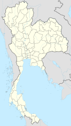
| Coordinates | 17 ° 25 ′ N , 102 ° 45 ′ E | |
| Symbols | ||
|
||
| Basic data | ||
| Country | Thailand | |
| Udon Thani | ||
| ISO 3166-2 | TH-41 | |
Udon Thani ( Thai อุดรธานี ) is the capital of the district ( Amphoe ) Udon Thani and the province of Udon Thani . The province of Udon Thani is located in the northeast region of Thailand , the Isan . The city has 143,081 inhabitants (as of 2008).
geography
Udon Thani is located about 60 kilometers south of the Laotian border ( Thai-Laotian Friendship Bridge ) and 560 km northeast of Bangkok in a plain of the Maenam Luang, one of the tributaries of the Mekong . Udon Thani is connected to the capital Bangkok by road and rail and has an airport (UTH) for domestic air traffic. Udon Thani belongs to the Isan, the northeast of Thailand.
religion
Buddhism is predominant in Udon Thani. Udon Thani is the seat of the Roman Catholic diocese of Udon Thani .
Economy and Importance
Udon Thani is an important trading city, especially in trade with Laos. The region is one of Thailand's rice chambers.
traffic
Road traffic
The city is located on major highways:
Airport
- Udon Thani Airport ( IATA Airport Code: UTH)
railroad
Udon Thani has a train station on the Nakhon Ratchasima – Nong Khai railway line , which connects to Bangkok on the one hand and runs from Nong Khai over the Mekong to Laos on the other .
history
The area around Udon Thani was already around 6,000 BC. Inhabited, numerous traces can be proven. The oldest settlement in Thailand, Ban Chiang , is also not far away on the road to Sakon Nakhon , about 50 kilometers east of Udon Thani.
For a long time this area was ruled by Laos (the kingdom of Lan Xang ) and the Khmer (see History of Thailand ). In the meantime, the Burmese had captured it in the 18th century after the conquest of Laos ( Vientiane ) before King Taksin could finally strike it in Thailand in 1772.
The city of Udon Thani was founded at the end of the 19th century by Prince Prajak Sillapakhom, a son of King Mongkut (Rama IV) , who is revered by its residents to this day. King Bhumibol Adulyadej , who died in 2016, owned a summer house there near the lake.
During the Vietnam War (1967-1975) there were numerous here stationed US troops, particularly at the airbase , which from the day Thai Air Force is used.
Attractions
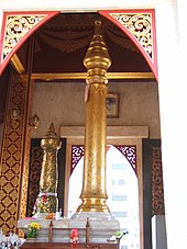
- Sao Lak Mueang - sanctuary for the good city spirits who are supposed to protect the city and its population; In contrast to most other consecrated places, there are two pillars here
- Buddhist temples ( Wat ) - all from more recent times, for example Wat Kham Chanot ( วัด คำ ชะ โน ด ) in Amphoe Ban Dung or Wat Pa Phu Kon ( วัด ป่า ภู ก้อน ) in Amphoe Na Yung .
- Market happenings on the weekend market and on the night market
- Nong Prajak Park
- The Museum of Udon Thani - The museum provides information on topics related to Udon Thani in a former schoolhouse built in 1920 on two floors.
Personalities
- Kiatjarern Ruangparn (* 1982), football player
- Panuwat Failai (* 1986), football player
- Koravit Namwiset (* 1986), football player
- Pongthep Mulalee (born 1988), football player
- Rachanon Kanyathong (born 1992), football player
- Apichai Munotsa (* 1992), football player
- Parinya Chuaimaroeng (* 1997), athletics
- Parichat Charoensuk (* 1998), sprinter
- Saranyu Plangwal (* 1999), football player
Climate table
| Udon Thani | ||||||||||||||||||||||||||||||||||||||||||||||||
|---|---|---|---|---|---|---|---|---|---|---|---|---|---|---|---|---|---|---|---|---|---|---|---|---|---|---|---|---|---|---|---|---|---|---|---|---|---|---|---|---|---|---|---|---|---|---|---|---|
| Climate diagram | ||||||||||||||||||||||||||||||||||||||||||||||||
| ||||||||||||||||||||||||||||||||||||||||||||||||
|
Average monthly temperatures and rainfall for Udon Thani
Source: wetterkontor.de
|
|||||||||||||||||||||||||||||||||||||||||||||||||||||||||||||||||||||||||||||||||||||||||||||||||||||||||


