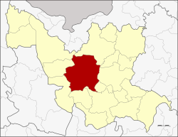
Amphoe Mueang Udon Thani
|
Amphoe Mueang Udon Thani อำเภอ เมือง อุดรธานี |
|
|---|---|
| Province: | Udon Thani |
| Surface: | 1094.7 km² |
| Residents: | 402,592 (2012) |
| Population density : | 358.5 U / km² |
| ZIP : | 41000, 41330 |
| Geocode : | 4101 |
| map | |

|
|
Amphoe Mueang Udon Thani ( Thai อำเภอ เมือง อุดรธานี ) is a district ( Amphoe - Administrative District) in the Udon Thani Province . The Udon Thani Province is located in the northwestern part of Isan , the northeast region of Thailand . The capital of Udon Thani Province is also called Udon Thani .
geography
Neighboring counties (from north clockwise) are the Amphoe Phen , Phibun Rak , Nong Han , Prachaksinlapakhom , Kumphawapi , Nong Saeng , Nong Wua So , Kut Chap and Ban Phue . All Amphoe are in Udon Thani Province.
history
Originally this district was called Ban Mak Khaeng ( บ้าน หมากแข้ง ). It was one of the four districts of Udon Thani established during the thesaphiban administrative reform in 1908. In 1938 Mak Khaeng was renamed Mueang Udon Thani.
traffic
Udon Thani Airport is located in this district .
education
The Rajabhat University of Udon Thani is located in Amphoe Mueang Udon Thani .
administration
Provincial Administration
The district of Mueang Udon Thani is divided into 21 municipalities ( tambon ) , which are further subdivided into 253 villages ( muban ) .
| No. | Surname | Thai | Muban | Pop. |
|---|---|---|---|---|
| 1. | Mak Khaeng | หมากแข้ง | - | 135.173 |
| 2. | Nikhom Songkhro | นิคม สงเคราะห์ | 12 | 11,855 |
| 3. | Ban Khao | บ้าน ขาว | 10 | 10.214 |
| 4th | Nong Bua | หนองบัว | 7th | 18,317 |
| 5. | Ban deed | บ้าน ตาด | 14th | 12,486 |
| 6th | Non Sung | โนนสูง | 14th | 19,951 |
| 7th | Mu Mon | หมู ม่น | 12 | 16,188 |
| 8th. | Chiang Yuen | เชียงยืน | 19th | 16,113 |
| 9. | Nong Na Kham | หนอง นา คำ | 18th | 23,433 |
| 10. | Kut Sa | กุด สระ | 11 | 8,650 |
| 11. | Well Tuesday | นาดี | 8th | 7,259 |
| 12. | Ban Lueam | บ้าน เลื่อม | 8th | 17,501 |
| 13. | Chiang Phin | เชียง พิณ | 10 | 11,609 |
| 14th | Sam Phrao | สาม พร้าว | 13 | 19,295 |
| 15th | Nong Hai | หนอง ไฮ | 15th | 12,627 |
| 16. | Well kha | นา ข่า | 16 | 12,771 |
| 17th | Ban Chan | บ้าน จั่น | 12 | 14,776 |
| 18th | Nong Khon Kwang | หนอง ขอน กว้าง | 10 | 11,192 |
| 19th | Khok Sa-at | โคก สะอาด | 10 | 7,387 |
| 20th | Well, Kwang | นา กว้าง | 12 | 7,063 |
| 21st | Nong Phai | หนองไผ่ | 12 | 8,732 |
Local administration
Udon Thani ( เทศบาลนคร อุดรธานี) is a large city ( Thesaban Nakhon ) in the district, it consists of the whole Tambon Makkhaeng and parts of Nong Bua and Nong Khon Kwang.
There are also two cities ( Thesaban Mueang ) in the district:
- Non Sung - Nam Kham ( เทศบาล เมือง โนนสูง - น้ำ คำ ) consists of parts of the Tambon Non Sung,
- Nong Samrong ( เทศบาล เมือง หนอง สำโรง ) consists of parts of the Tambon Mu Mon, Na Di and Ban Lueam.
There are also seven small towns ( Thesaban Tambon ) in the district:
- Na Kha ( เทศบาล ตำบล นา ข่า ) consists of parts of the Tambon Na Kha,
- Nikhom Songkhro ( เทศบาล ตำบล นิคม สงเคราะห์ ) consists of parts of the tambon Nikhom Songkhro and Khok Sa-at,
- Ban Chan ( เทศบาล ตำบล บ้าน จั่น ) consists of parts of the tambon Ban Chan and Nong Khon Kwang,
- Nong Bua ( เทศบาล ตำบล หนองบัว ) consists of parts of the Tambon Nong Bua, Nong Na Kham, Sam Phrao and Nong Khon Kwang,
- Nong Phai ( เทศบาล ตำบล หนองไผ่ ) consists of the whole Tambon Nong Phai,
- Nong Khon Kwang ( เทศบาล ตำบล หนอง ขอน กว้าง ) consists of further parts of the Tambon Nong Khon Kwang,
- Ban Tat ( เทศบาล ตำบล บ้าน ตาด ) consists of the whole Tambon Ban Tat.
There are also 15 “Tambon Administrative Organizations” (TAO, องค์การ บริหาร ส่วน ตำบล - administrative organizations) for the tambon in the district that do not belong to any city.
Individual evidence
- ↑ แจ้ง ความ กระทรวง มหาดไทย เรื่อง ให้ รวม เมือง ก มุทธา ไส ๑ เมือง กุมภวาปี ๑ เมือง หนอง หาย ๑ อำเภอ บ้าน หมากแข้ง ๑ ตั้ง เป็น เมือง จัตวา จัตวา เรียก ว่า เมือง อุดรธานี บริเวณ น้ำ ชี ให้ เปลี่ยน เรียก ว่า เมือง ขอนแก่น บริเวณ น้ำ เหื อง ว่า เมือง เรียก เรียก เรียก เรียก เรียก เรียก เรียก เลย บริเวณ สกลนคร ให้ เปลี่ยน เรียก ว่า เมือง สกลนคร บริเวณ ธาตุพนม ให้ เปลี่ยน เรียก ว่า เมือง นครพนม ส่วน เมือง หนองคาย เมือง โพนพิสัย ให้ คง ไว้ ตาม เดิม . In: Royal Gazette . 24, No. 41, January 12, 1908, p. 1088.
- ↑ พระราชกฤษฎีกา เปลี่ยน นาม จังหวัด และ อำเภอ บาง แห่ง พุทธศักราช ๒๔๘๑ . In: Royal Gazette . 55, No. 0 ก , November 14, 1938, pp. 658-666.
- ↑ Population statistics 2012 . Department of Provincial Administration. Retrieved June 25, 2014.
Web links
Coordinates: 17 ° 25 ' N , 102 ° 45' E
