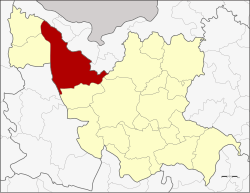
Ban Phue district
|
Ban Phue บ้าน ผื อ |
|
|---|---|
| Province: | Udon Thani |
| Surface: | 991.2 km² |
| Residents: | 109,431 (2012) |
| Population density : | 108.2 U / km² |
| ZIP : | 41160 |
| Geocode : | 4117 |
| map | |

|
|
Amphoe Ban Phue ( Thai : อำเภอ บ้าน ผื อ ) is a district ( Amphoe - administrative district) in the northwest of Udon Thani Province . The Udon Thani Province is located in the northwestern part of Isan , the northeast region of Thailand .
geography
Neighboring districts (clockwise from north): the Sangkhom , Pho Tak , Tha Bo and Sakhrai districts of Nong Khai Province , Phen , Mueang Udon Thani and Kut Chap districts of Udon Thani Province, Suwannakhuha district of Nong Bua Lamphu Province and the amphoe Nam Som and Na Yung again in Udon Thani.
Attractions
- Phu Phrabat (Thai: อุทยาน ประวัติศาสตร์ ภู พระบาท ) - Historical Park near Ban Phue, about 50 km northwest of the provincial capital, is an archaeological excavation site with finds from the Dvaravati period, the kingdom of Lop Buri and Lan Xang (Laos)
- Phu Phrabat Buabok Forest Park (Thai: วนอุทยาน ภู พระบาท บัวบก ) - 13 km² protected forest area in Tambon Mueang Phan
administration
Provincial Administration
Amphoe Ban Phue is divided into 13 communities ( Tambon ) , which in turn are divided into 160 villages ( Muban ) .
| No. | Surname | Thai | Villages | Pop. |
|---|---|---|---|---|
| 1. | Ban Phue | บ้าน ผื อ | 14th | 13,415 |
| 2. | Hai Sok | หาย โศก | 17th | 11,089 |
| 3. | Khuea Nam | เขือ น้ำ | 15th | 9,324 |
| 4th | Kham bong | คำ บ ง | 10 | 6,975 |
| 5. | Non thong | โนน ทอง | 11 | 10,757 |
| 6th | Khao San | ข้าวสาร | 10 | 5,721 |
| 7th | Champa Mong | จำปา โมง | 17th | 10,516 |
| 8th. | Sounded yai | กลาง ใหญ่ | 13 | 8,929 |
| 9. | Mueang Phan | เมือง พาน | 16 | 8,622 |
| 10. | Kham Duang | คำ ด้วง | 10 | 6,674 |
| 11. | Nong Hua Khu | หนอง หัว คู | 11 | 7,349 |
| 12. | Ban Kho | บ้าน ค้อ | 6th | 3,103 |
| 13. | Nong Waeng | หนอง แวง | 10 | 6,957 |
Local administration
There are three small towns ( Thesaban Tambon ) in the county:
- Ban Phue ( เทศบาล ตำบล บ้าน ผื อ ) consists of parts of the Tambon Ban Phue,
- Kham Bong ( เทศบาล ตำบล คำ บ ง ) consists of the entire Tambon Kham Bong,
- Klang Yai ( เทศบาล ตำบล กลาง ใหญ่ ) consists of the entire Tambon Klang Yai,
There are also eleven "Tambon Administrative Organizations" (TAO, องค์การ บริหาร ส่วน ตำบล - administrative organizations) for the tambon in the district that do not belong to any city.
Individual evidence
- ↑ Population statistics 2012 . Department of Provincial Administration. Retrieved June 24, 2014.
Web links
- More details on Amphoe Ban Phue from amphoe.com (in Thai)
- Information on Phu Phra Bat Buabok Forest Park (in English)
Coordinates: 17 ° 41 ′ N , 102 ° 28 ′ E
