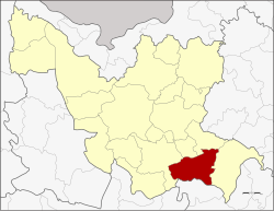
Si That district
|
Si That ศรีธาตุ |
|
|---|---|
| Province: | Udon Thani |
| Surface: | 512.5 km² |
| Residents: | 48,572 (2012) |
| Population density : | 93 U / km² |
| ZIP : | 41230 |
| Geocode : | 4109 |
| map | |

|
|
Amphoe Si That ( Thai : อำเภอ ศรีธาตุ , also: Sri That) is a district ( Amphoe - administrative district) in the southeast of the province of Udon Thani . The Udon Thani Province is located in the northwestern part of Isan , the northeast region of Thailand .
geography
Neighboring districts (from west clockwise): Amphoe Kumphawapi , Ku Kaeo , Chai Wan and Wang Sam Mo in the province of Udon Thani Province, as well as Amphoe Tha Khantho of Kalasin Province .
history
Si That was initially set up as a small district ( King Amphoe ) on March 1, 1968 by separating the five Tambon Champi, Na Yung, Nong Ya Sai, Ban Prong and Nong Kung Thap Ma from the Kumphawapi district . The promotion to full amphoe took place on June 28, 1973.
administration
Provincial Administration
Amphoe Si That is divided into 7 communities ( tambon ) , which in turn are divided into 86 villages ( muban ) .
| No. | Surname | Thai | Villages | Pop. |
|---|---|---|---|---|
| 1. | Si That | ศรีธาตุ | 12 | 8,290 |
| 2. | Champi | จำปี | 17th | 8,061 |
| 3. | Ban Prong | บ้าน โปร่ง | 11 | 5,468 |
| 4th | Hua Na Kham | หัว นา คำ | 17th | 10,956 |
| 5. | Nong Nok Khian | หนอง นก เขียน | 8th | 4,461 |
| 6th | Well Yung | นา ยูง | 10 | 5.112 |
| 7th | Tat Thong | ตาด ทอง | 11 | 6.224 |
Local administration
There are 4 small towns ( Thesaban Tambon ) in the district:
- Si That ( เทศบาล ตำบล ศรีธาตุ ), consisting of parts of the Tambon Si That.
- Champi ( เทศบาล ตำบล จำปี ), consisting of the entire Tambon Champi,
- Hua Na Kham ( เทศบาล ตำบล หัว นา คำ ), consisting of the entire Tambon Hua Na Kham,
- Ban Prong ( เทศบาล ตำบล บ้าน โปร่ง ), consisting of the entire tambon Ban Prong.
There are also four “Tambon Administrative Organizations” (TAO, องค์การ บริหาร ส่วน ตำบล - administrative organizations) for the tambon in the district that do not belong to any city.
Individual evidence
- ↑ ประกาศ กระทรวง มหาดไทย เรื่อง แบ่ง ท้องที่ ตั้ง เป็น กิ่ง อำเภอ . In: Royal Gazette . 85, No. 24 ง , March 12, 1968, p. 798.
- ↑ พระราชกฤษฎีกา ตั้ง อำเภอ เขาพนม อำเภอ สนามชัยเขต อำเภอ แม่อาย อำเภอ ขามสะแกแสง อำเภอ เก้าเลี้ยว อำเภอ โพธิ์ประทับช้าง อำเภอ หนองพอก อำเภอ ละอุ่น อำเภอ ทุ่งหว้า และ อำเภอ ศรีธาตุ พ.ศ. ๒๕๑๖ . In: Royal Gazette . 90, No. 75 ก ฉบับ พิเศษ (special), June 28, 1973, pp. 32-36.
- ↑ Population statistics 2012 . Department of Provincial Administration. Retrieved June 25, 2014.
Web links
Coordinates: 16 ° 58 ' N , 103 ° 13' E
