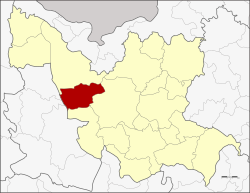
Amphoe Kut Chap
|
Kut Chap กุดจับ |
|
|---|---|
| Province: | Udon Thani |
| Surface: | 785.0 km² |
| Residents: | 64,555 (2012) |
| Population density : | 79.4 U / km² |
| ZIP : | 41250 |
| Geocode : | 4102 |
| map | |

|
|
Amphoe Kut Chap (in Thai อำเภอ กุดจับ ) is a district ( Amphoe - administrative district) in the west of Udon Thani Province . The Udon Thani Province is located in the northwestern part of Isan , the northeast region of Thailand .
geography
Neighboring districts (from north clockwise): Amphoe Ban Phue , Mueang Udon Thani and Nong Wua So in Udon Thani province, as well as the Amphoe Na sound and Suwannakhuha the province of Nong Bua Lamphu Province .
history
Kut Chap was initially set up as a subdistrict ( King Amphoe ) on July 20, 1972 , by separating the three tambon Kut Chap, Pa Kho and Chiang Pheng from the Mueang Udon Thani district . On September 8, 1976, it was promoted to Amphoe.
administration
Provincial Administration
Amphoe Kut Chap is divided into seven communities ( tambon ) , which in turn are divided into 90 villages ( muban ) .
| No. | Surname | Thai | Muban | Pop. |
|---|---|---|---|---|
| 1. | Kut Chap | กุดจับ | 12 | 9,109 |
| 2. | Pa Kho | ปะ โค | 14th | 9,070 |
| 3. | Khon Yung | ขอน ยูง | 14th | 9,322 |
| 4th | Chiang Pheng | เชียง เพ็ง | 14th | 9.416 |
| 5. | Sang Ko | สร้าง ก่อ | 13 | 8,895 |
| 6th | Mueang Phia | เมือง เพี ย | 15th | 12,758 |
| 7th | Tan Lian | ตาล เลียน | 8th | 5,985 |
Local administration
There are seven small towns ( Thesaban Tambon ) in the county:
- Kut Chap ( เทศบาล ตำบล กุดจับ ) consisting of parts of the tambon Kut Chap and Mueang Phia,
- Chiang Pheng ( เทศบาล ตำบล เชียง เพ็ง ) consisting of parts of the Tambon Chiang Pheng,
- Tan Lian ( เทศบาล ตำบล ตาล เลียน ) consisting of parts of the tambon Tan Lian.
- Sang Ko ( เทศบาล ตำบล สร้าง ก่อ ) consisting of parts of the Tambon Sang Ko,
- Mueang Phia ( เทศบาล ตำบล เมือง เพี ย ) consisting of further parts of the tambon Mueang Phia,
- Pa Kho ( เทศบาล ตำบล ปะ โค ) consisting of the whole tambon Pa Kho,
- Yang Chum ( เทศบาล ตำบล ยาง ชุม ) consisting of further parts of the Tambon Chiang Pheng.
There are also four “Tambon Administrative Organizations” (TAO, องค์การ บริหาร ส่วน ตำบล - administrative organizations) for the tambon in the district that do not belong to any city.
Individual evidence
- ↑ ประกาศ กระทรวง มหาดไทย เรื่อง แบ่ง ท้องที่ อำเภอ เมือง อุดรธานี จังหวัด อุดรธานี ตั้ง เป็น กิ่ง อำเภอ กุดจับ . In: Royal Gazette . 89, No. 109 ง , July 18, 1972, p. 1828.
- ↑ พระราชกฤษฎีกา ตั้ง อำเภอ เลาขวัญ อำเภอ คำม่วง อำเภอ พิปูน อำเภอ ศรีเทพ อำเภอ นาแห้ว อำเภอ ส่องดาว อำเภอ ควนกาหลง อำเภอ ค่ายบางระจัน อำเภอ บ้านตาขุน และ อำเภอ กุดจับ พ.ศ. ๒๕๑๙ . In: Royal Gazette . 93, No. 109 ก ฉบับ พิเศษ (special), September 8, 1976, pp. 31-34.
- ↑ Population statistics 2012 . Department of Provincial Administration. Retrieved June 24, 2014.
Web links
Coordinates: 17 ° 26 ' N , 102 ° 34' E
