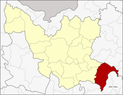
Amphoe Wang Sam Mon.
|
Wang Sam Mo วังสามหมอ |
|
|---|---|
| Province: | Udon Thani |
| Surface: | 727.3 km² |
| Residents: | 57,731 (2012) |
| Population density : | 77 U / km² |
| ZIP : | 41280 |
| Geocode : | 4110 |
| map | |

|
|
Amphoe Wang Sam Mo ( Thai : อำเภอ วังสามหมอ ) is a district ( amphoe - administrative district) in the southeast of Udon Thani Province . The Udon Thani Province is located in the northwestern part of Isan , the northeast region of Thailand .
geography
Adjacent areas (from the west in the clockwise direction), the Amphoe Si That and Chai Wan in the province of Udon Thani, the Amphoe Waritchaphum , Nikhom Nam Un and Kut Bak the province Sakon Nakhon and Amphoe Kham Muang , Sam Chai , Nong Kung Si and Tha Khantho of Kalasin Province .
history
Wang Sam Mo was initially set up as a subdistrict ( King Amphoe ) on October 1, 1975 by separating the three Tambon Nong Kung Thap Ma, Ba Yao and Nong Ya Sai from the Si That district . On July 13, 1981, it was upgraded to a full Amphoe.
administration
Provincial Administration
Amphoe Wang Sam Mo is divided into 6 communities ( tambon ) , which in turn are divided into 72 villages ( muban ) .
| No. | Surname | Thai | Villages | Pop. |
|---|---|---|---|---|
| 1. | Nong Kung Thap Ma | หนอง กุ ง ทับ ม้า | 11 | 7,922 |
| 2. | Nong Ya Sai | หนอง หญ้า ไซ | 9 | 7,648 |
| 3. | Ba Yao | บะ ยาว | 12 | 9,441 |
| 4th | Phasuk | ผาสุก | 18th | 15,421 |
| 5. | Kham Khok Sung | คำ โคก สูง | 9 | 5,615 |
| 6th | Wang Sam Mo | วังสามหมอ | 13 | 11,683 |
Local administration
There are five small towns ( Thesaban Tambon ) in the county:
- Wang Sam Mo ( เทศบาล ตำบล วังสามหมอ ), consisting of parts of the tambon Wang Sam Mo,
- Lamphan Chat ( เทศบาล ตำบล ลำ พัน ชาด ), consisting of further parts of the Tambon Wang Sam Mo,
- Phasuk ( เทศบาล ตำบล ผาสุก ), consisting of the entire Tambon Phasuk,
- Nong Ya Sai ( เทศบาล ตำบล หนอง หญ้า ไซ ), consisting of the entire tambon Nong Ya Sai,
- Ba Yao ( เทศบาล ตำบล บะ ยาว ), consisting of the entire tambon Ba Yao.
There are also two “Tambon Administrative Organizations” (TAO, องค์การ บริหาร ส่วน ตำบล - administrative organizations) for the tambon in the district that do not belong to any city.
Individual evidence
- ↑ ประกาศ กระทรวง มหาดไทย เรื่อง แบ่ง ท้องที่ อำเภอ ศรีธาตุ จังหวัด อุดรธานี ตั้ง เป็น กิ่ง อำเภอ วังสามหมอ . In: Royal Gazette . 92, No. 202 ง , September 30, 1975, p. 2412.
- ↑ พระราชกฤษฎีกา ตั้ง อำเภอ หนองใหญ่ อำเภอ บ่อไร่ อำเภอ พรหมคีรี อำเภอ นาบอน อำเภอ บางสะพาน น้อย อำเภอ นาดี อำเภอ กงหรา อำเภอ วังทรายพูน อำเภอ ธารโต อำเภอ คำตากล้า อำเภอ อำเภอ ศรีนคร อำเภอ ด่านช้าง อำเภอ พรเจริญ อำเภอ วังสามหมอ และ อำเภอ ลานสัก พ.ศ. ๒๕๒๔ . In: Royal Gazette . 98, No. 115 ก ฉบับ พิเศษ (special), July 13, 1981, pp. 7-10.
- ↑ Population statistics 2012 . Department of Provincial Administration. Retrieved June 25, 2014.
Web links
Coordinates: 16 ° 57 ' N , 103 ° 26' E
