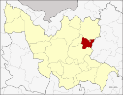
Amphoe Thung Fon
|
Thung Fon ทุ่งฝน |
|
|---|---|
| Province: | Udon Thani |
| Surface: | 227.903 km² |
| Residents: | 31,793 (2012) |
| Population density : | 136 U / km² |
| ZIP : | 41310 |
| Geocode : | 4107 |
| map | |

|
|
Amphoe Thung Fon ( Thai อำเภอ ทุ่งฝน ) is a district ( Amphoe - administrative district) in the east of Udon Thani Province . The Udon Thani Province is located in the northwestern part of Isan , the northeast region of Thailand .
geography
Neighboring districts (from the south clockwise) Amphoe Nong Han , Phibun Rak and Ban Dung in Udon Thani province, as well as the Amphoe Sawang Daen Din the province of Sakon Nakhon .
history
Thung Fon was initially set up as a small district ( King Amphoe ) on July 1, 1976 , when the two tambon Thung Fon and Thung Yai were separated from the Nong Han district . It was upgraded to full amphoe on May 21, 1990.
administration
Provincial Administration
Amphoe Thung Fon is divided into four communities ( Tambon ) , which in turn are divided into 37 villages ( Muban ) .
| No. | Surname | Thai | Muban | Pop. |
|---|---|---|---|---|
| 1. | Thung Fon | ทุ่งฝน | 13 | 12,769 |
| 2. | Thung Yai | ทุ่งใหญ่ | 10 | 9,368 |
| 3. | Well Chum Saeng | นา ชุมแสง | 8th | 6.164 |
| 4th | Well Thom | นา ทม | 6th | 3,492 |
Local administration
There are two small towns ( Thesaban Tambon ) in the county:
- Thung Fon (Thai: เทศบาล ตำบล ทุ่งฝน ), consisting of parts of the tambon Thung Fon,
- Thung Yai (Thai: เทศบาล ตำบล ทุ่งใหญ่ ), consisting of the entire tambon Thung Yai.
There are also three “Tambon Administrative Organizations” (TAO, องค์การ บริหาร ส่วน ตำบล - administrative organizations) for the tambon in the district that do not belong to any city.
Individual evidence
- ↑ ประกาศ กระทรวง มหาดไทย เรื่อง แบ่ง ท้องที่ อำเภอ หนองหาน จังหวัด อุดรธานี ตั้ง เป็น กิ่ง อำเภอ ทุ่งฝน . In: Royal Gazette . 93, No. 87 ง , June 29, 1976, p. 1637.
- ↑ พระราชกฤษฎีกา ตั้ง อำเภอ ห้วย ผึ้ง อำเภอ วัง วิเศษ อำเภอ คลอง หาด อำเภอ ป่า บอน อำเภอ หนองหญ้าปล้อง อำเภอ วัง โป่ง อำเภอ ควน เนียง อำเภอ หนอง หนอง หญ้า ไซ อำเภอ บ้านนาเดิม อำเภอ ทุ่งฝน อำเภอ สร้างคอม และ อำเภอ ทอง แสน ขัน พ.ศ. ๒๕๓๓ . In: Royal Gazette . 107, No. 83 ก ฉบับ พิเศษ (special), May 21, 1990, pp. 1-4.
- ↑ Population statistics 2012 . Department of Provincial Administration. Retrieved June 25, 2014.
Web links
- More details about Thung Fon Amphoe (in Thai)
Coordinates: 17 ° 28 ' N , 103 ° 16' E
