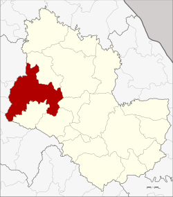
Sawang Daen Din district
|
Sawang Daen Din สว่างแดนดิน |
|
|---|---|
| Province: | Sakon Nakhon |
| Surface: | 970.0 km² |
| Residents: | 149,937 (2013) |
| Population density : | 151 U / km² |
| ZIP : | 47110, 47240 |
| Geocode : | 4712 |
| map | |

|
|
Amphoe Sawang Daen Din ( Thai อำเภอ สว่างแดนดิน ) is a district ( Amphoe - Administrative District) of the Sakon Nakhon Province . The province of Sakon Nakhon is located in the northeast region of Thailand , the so-called Isan .
geography
Amphoe Sawang Daen Din is located in the west of the province of Sakon Nakhon and, seen from the north, borders in a clockwise direction with the Amphoe Charoen Sin , Wanon Niwat , Phang Khon , Waritchaphum and Song Dao in the Province of Sakon Nakhon Province, as well as the Amphoe Chai Wan , Nong Han , Thung Fon and Ban Dung of Udon Thani Province .
history
Amphoe Sawang Daen Din emerged from the former Mueang Sawang Daen Din, which was made into an amphoe in the course of the Thesaphiban administrative reform around 1900 and was called Ban Han. In 1939 the amphoe was renamed to its current name.
administration
Provincial Administration
Sawang Daen Din County is divided into 16 tambon ("subdistricts" or "parishes"), which are further subdivided into 189 muban ("villages").
| No. | Surname | Thai | Muban | Pop. |
|---|---|---|---|---|
| 1. | Sawang Daen Din | สว่างแดนดิน | 27 | 30.097 |
| 3. | Kham Sa-at | คำ สะอาด | 14th | 10,852 |
| 4th | Ban Tai | บ้าน ต้าย | 7th | 6,370 |
| 6th | Bong Nuea | บ ง เหนือ | 12 | 10,689 |
| 7th | Phon Sung | โพน สูง | 9 | 6,044 |
| 8th. | Khok Si | โคก สี | 14th | 11,337 |
| 10. | Nong Luang | หนอง หลวง | 12 | 8,181 |
| 11. | Bong tai | บ ง ใต้ | 15th | 9,984 |
| 12. | Kho Tai | ค้อ ใต้ | 10 | 6,805 |
| 13. | Phan Na | พัน นา | 12 | 6,898 |
| 14th | Waeng | แวง | 11 | 10,605 |
| 15th | Sai Mun | ทรายมูล | 8th | 7,042 |
| 16. | Tan Kon | ตาล โกน | 11 | 6,032 |
| 17th | Tan Noeng | ตาล เนิ้ ง | 9 | 4,957 |
| 20th | That thong | ธาตุทอง | 8th | 5,834 |
| 21st | Ban Thon | บ้าน ถ่อ น | 10 | 8,210 |
Note: The missing numbers (geocodes) were assigned to tambon, which today belongs to the Charoen Sin district.
Local administration
There are seven municipalities with "small town" status ( Thesaban Tambon ) in the district:
- Ban Tai (Thai: เทศบาล ตำบล บ้าน ต้าย ), consisting of the entire tambon Ban Tai.
- Khok Si (Thai: เทศบาล ตำบล โคก สี ), consisting of the entire tambon Khok Si.
- Nong Luang (Thai: เทศบาล ตำบล หนอง หลวง ), consisting of the entire Tambon Nong Luang.
- Phan Na (Thai: เทศบาล ตำบล พัน นา ), consisting of the entire tambon Phan Na.
- Don Khueang (Thai: เทศบาล ตำบล ดอน เขือง ), consisting of parts of the Tambon Waeng.
- Sawang Daen Din (Thai: เทศบาล ตำบล สว่างแดนดิน ), consisting of parts of the tambon Sawang Daen Din.
- Bong Tai (Thai: เทศบาล ตำบล บ ง ใต้ ), consisting of the entire Tambon Bong Tai.
There are also eleven " Tambon Administrative Organizations " ( องค์การ บริหาร ส่วน ตำบล - Tambon Administrative Organizations, TAO):
- Sawang Daen Din (Thai: องค์การ บริหาร ส่วน ตำบล สว่างแดนดิน )
- Kham Sa-at (Thai: องค์การ บริหาร ส่วน ตำบล คำ สะอาด )
- Bong Nuea (Thai: องค์การ บริหาร ส่วน ตำบล บ ง เหนือ )
- Phon Sung (Thai: องค์การ บริหาร ส่วน ตำบล โพน สูง )
- Kho Tai (Thai: องค์การ บริหาร ส่วน ตำบล ค้อ ใต้ )
- Waeng (Thai: องค์การ บริหาร ส่วน ตำบล แวง )
- Sai Mun (Thai: องค์การ บริหาร ส่วน ตำบล ทรายมูล )
- Tan Kon (Thai: องค์การ บริหาร ส่วน ตำบล ตาล โกน )
- Tan Noeng (Thai: องค์การ บริหาร ส่วน ตำบล ตาล เนิ้ ง )
- That Thong (Thai: องค์การ บริหาร ส่วน ตำบล ธาตุทอง )
- Ban Thon (Thai: องค์การ บริหาร ส่วน ตำบล บ้าน ถ่อ น )
Individual evidence
- ↑ พระราชกฤษฎีกา เปลี่ยน นาม อำเภอ กิ่ง อำเภอ และ ตำบล บาง แห่ง พุทธศักราช ๒๔๘๒ . In: Royal Gazette . 56, No. 0 ก , April 17, 1939, pp. 354-364.
- ↑ 2013 population statistics ( Thai ) Department of Provincial Administration. Retrieved August 3, 2014.
Web links
Coordinates: 17 ° 29 ′ N , 103 ° 27 ′ E
