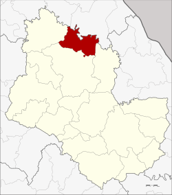
Amphoe Kham Ta Kla
|
Kham Ta Kla อำเภอ คำตากล้า |
|
|---|---|
| Province: | Sakon Nakhon |
| Surface: | 402.0 km² |
| Residents: | 39,276 (2013) |
| Population density : | 94.3 U / km² |
| ZIP : | 47250 |
| Geocode : | 4709 |
| map | |

|
|
Amphoe Kham Ta Kla ( Thai : อำเภอ คำตากล้า ) is a district ( amphoe - administrative district) in the province of Sakon Nakhon . The province of Sakon Nakhon is located in the northeast region of Thailand , the so-called Isan .
geography
Neighboring districts (from southeast clockwise) the Amphoe Akat Amnuai , Wanon Niwat and Ban Muang the province of Sakon Nakhon and Amphoe Phon Charoen and Seka the province Nong Khai .
history
The district of Kham Ta Kla was initially set up on September 15, 1976 as a "branch district" ( King Amphoe ) by separating the three tambon Kham Ta Kla, Nong Bua Sim and Na Tae from the Wanon Niwat district . On July 13, 1981, he got full amphoe status.
Administrative units
Provincial Administration
The district of Kham Ta Kla is divided into four tambon ("subdistricts" or "parishes"), which are further subdivided into 61 muban ("villages").
| No. | Surname | Thai | Muban | Pop. |
|---|---|---|---|---|
| 1. | Kham Ta Kla | คำตากล้า | 16 | 11,993 |
| 2. | Nong Bua Sim | หนองบัว สิ ม | 16 | 8,669 |
| 3. | Well Tae | นา แต้ | 12 | 8,491 |
| 4th | Phaet | แพ ด | 17th | 10.123 |
Local administration
There are two municipalities with "small town" status ( Thesaban Tambon ) in the district:
- Phaet (Thai: เทศบาล ตำบล แพ ด ) consists of the entire Tambon Phaet.
- Kham Ta Kla (Thai: เทศบาล ตำบล คำตากล้า ) consists of parts of the Tambon Kham Ta Kla.
There are also three " Tambon Administrative Organizations " ( องค์การ บริหาร ส่วน ตำบล - Tambon Administrative Organizations, TAO):
- Kham Ta Kla (Thai: องค์การ บริหาร ส่วน ตำบล คำตากล้า )
- Nong Bua Sim (Thai: องค์การ บริหาร ส่วน ตำบล หนองบัว สิ ม )
- Na Tae (Thai: องค์การ บริหาร ส่วน ตำบล นา แต้ )
Individual evidence
- ↑ ประกาศ กระทรวง มหาดไทย เรื่อง แบ่ง ท้องที่ อำเภอ วานรนิวาส จังหวัด สกลนคร ตั้ง เป็น กิ่ง อำเภอ คำตากล้า Royal Gazette, Vol. 93, Ed. 110 ง of September 14, 1976, p. 2461 (in Thai)
- ↑ พระราชกฤษฎีกา ตั้ง อำเภอ หนองใหญ่ อำเภอ บ่อไร่ อำเภอ พรหมคีรี อำเภอ นาบอน อำเภอ บางสะพาน น้อย อำเภอ นาดี อำเภอ กงหรา อำเภอ วังทรายพูน อำเภอ ธารโต อำเภอ คำตากล้า อำเภอ อำเภอ ศรีนคร อำเภอ ด่านช้าง อำเภอ พรเจริญ อำเภอ วังสามหมอ และ อำเภอ ลานสัก พ.ศ. ๒๕๒๔ Royal Gazette, Vol. 98, Ed. 115 ก special ( ฉบับ พิเศษ ) of July 13, 1981, pp. 7-10 (in Thai)
- ↑ 2013 population statistics ( Thai ) Department of Provincial Administration. Retrieved August 3, 2014.
Web links
Coordinates: 17 ° 51 ' N , 103 ° 45' E
