Amphoe Seka
|
Seka เซกา |
|
|---|---|
| Province: | Bueng Kan |
| Surface: | 978.428 km² |
| Residents: | 85,329 (2013) |
| Population density : | 82.3 U / km² |
| ZIP : | 38150 |
| Geocode : | 3804 |
| map | |

|
|
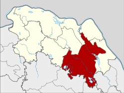
Amphoe Seka ( Thai : อำเภอ เซกา ) is a district ( Amphoe - administrative district) in the east of Bueng Kan Province . The province of Bueng Kan is located in the north of the northeast region of Thailand , the so-called Isan .
geography
The province of Bueng Kan is located about 615 kilometers northeast of Bangkok along the Mekong , which is the border with Laos .
Amphoe Seka borders the following counties (clockwise from west): Amphoe Phon Charoen , Si Wilai , Bueng Kan , Bung Khla and Bueng Khong Long in Nong Khai Province, Amphoe Na Thom in Nakhon Phanom Province and the Amphoe Akat Amnuai , Kham Ta Kla and Ban Muang in the province of Sakon Nakhon .
The largest river in the county is the Maenam Songkhram .
The Phu Wua Nature Reserve is also in the county.
history
On November 16, 1958, Seka was initially set up as a “branch circle” ( King Amphoe ) by separating the five Tambon Seka, Dong Bang, Sang, Pho Mak Khaeng and Tha Kok Daeng from the Bueng Kan district . In the following year, Seka received full amphoe status.
administration
Provincial Administration
The district of Seka is divided into nine tambon ("subdistricts" or "municipalities"), which are further subdivided into 136 muban ("villages").
| No. | Surname | Thai | Muban | Pop. |
|---|---|---|---|---|
| 1. | Seka | เซกา | 23 | 18,948 |
| 2. | Sang | ซาง | 13 | 8,659 |
| 3. | Tha Kok Daeng | ท่า กก แดง | 16 | 7,038 |
| 4th | Ban Tong | บ้าน ต้อง | 15th | 11,050 |
| 5. | Pong Hai | ป่ง ไฮ | 18th | 10,387 |
| 6th | Nam Chan | น้ำ จั้ น | 13 | 6,359 |
| 7th | Tha Sa-at | ท่า สะอาด | 13 | 9,711 |
| 8th. | Nong Thum | หนอง ทุ่ม | 13 | 6,994 |
| 9. | Sok Kam | โสก ก่า ม | 12 | 6,183 |
Local administration
There are three municipalities with "small town" status ( Thesaban Tambon ) in the district:
- Sang (Thai: เทศบาล ตำบล ซาง ) consists of the entire Tambon Sang.
- Tha Sa-at (Thai: เทศบาล ตำบล ท่า สะอาด ) consists of parts of the tambon Tha Sa-at.
- Si Phana (Thai: เทศบาล ตำบล ศรี พนา ) consists of parts of the Tambon Seka.
There are also eight " Tambon Administrative Organizations " ( องค์การ บริหาร ส่วน ตำบล - Tambon Administrative Organizations, TAO):
- Seka (Thai: องค์การ บริหาร ส่วน ตำบล เซกา )
- Tha Kok Daeng (Thai: องค์การ บริหาร ส่วน ตำบล ท่า กก แดง )
- Ban Tong (Thai: องค์การ บริหาร ส่วน ตำบล บ้าน ต้อง )
- Pong Hai (Thai: องค์การ บริหาร ส่วน ตำบล ป่ง ไฮ )
- Nam Chan (Thai: องค์การ บริหาร ส่วน ตำบล น้ำ จั้ น )
- Tha Sa-at (Thai: องค์การ บริหาร ส่วน ตำบล ท่า สะอาด )
- Nong Thum (Thai: องค์การ บริหาร ส่วน ตำบล หนอง ทุ่ม )
- Sok Kam (Thai: องค์การ บริหาร ส่วน ตำบล โสก ก่า ม )
Individual evidence
- ↑ ประกาศ กระทรวง มหาดไทย เรื่อง ยก ฐานะ ตำบล ขึ้น เป็น กิ่ง อำเภอ . In: Royal Gazette . 75, No. 95 ง , November 18, 1958, pp. 2929-2930.
- ↑ พระราชกฤษฎีกา ตั้ง อำเภอ ชุมพวง อำเภอ เชียงยืน อำเภอ แก้ง ค ร้ อ อำเภอ สำโรงทาบ อำเภอ คอน สาร อำเภอ เซกา อำเภอ ทุ่งเสลี่ยม อำเภอ บ้าน ด่าน ด่าน อำเภอ ขนอม อำเภอ บ้านแพรก อำเภอ กระทู้ และ อำเภอ คลองใหญ่ พ.ศ. ๒๕๐๒ . In: Royal Gazette . 76, No. 113 ก ฉบับ พิเศษ , January 10, 1959, p. 8.
- ↑ 2013 population statistics ( Thai ) Department of Provincial Administration. Retrieved August 4, 2014.
Web links
Coordinates: 17 ° 56 ' N , 103 ° 57' E