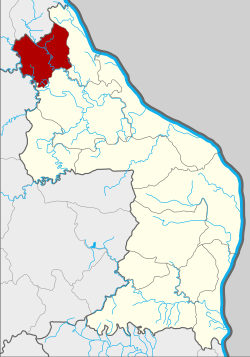
Amphoe Na Thom
|
Well Thom นา ทม |
|
|---|---|
| Province: | Nakhon Phanom |
| Surface: | 398.1 km² |
| Residents: | 23,032 (2013) |
| Population density : | 55.1 U / km² |
| ZIP : | 48140 |
| Geocode : | 4811 |
| map | |

|
|
Amphoe Na Thom ( Thai : อำเภอ นา ทม ) is a district ( Amphoe - administrative district) of the Nakhon Phanom Province . The province of Nakhon Phanom is located in the northeast region of Thailand , the so-called Isan .
geography
Nakhon Phanom is located on the extreme northeastern border of Thailand on the border with Laos on the banks of the Mekong .
Neighboring districts (clockwise from east): Ban Phaeng and Si Songkhram districts in Nakhon Phanom Province, Akat Amnuai districts in Sakon Nakhon Province, and Seka and Bueng Khong Long districts in Nong Khai Province .
history
Na Thom was initially set up on April 1, 1992 as a “branch circle” ( King Amphoe ) by separating three tambon from Ban Phaeng district . Na Thom was promoted to Amphoe on October 11, 1997.
administration
Provincial Administration
The district of Na Thom is divided into three tambon ("subdistricts" or "municipalities"), which are further subdivided into 36 Muban ("villages").
| No. | Surname | Thai | Muban | Pop. |
|---|---|---|---|---|
| 1. | Well Thom | นา ทม | 15th | 8,495 |
| 2. | Nong Son | หนอง ซน | 13 | 8,997 |
| 3. | Don Toei | ดอน เตย | 8th | 5,540 |
Local administration
There are three " Tambon Administrative Organizations " ( องค์การ บริหาร ส่วน ตำบล - Tambon Administrative Organizations, TAO) in the district:
- Na Thom (Thai: องค์การ บริหาร ส่วน ตำบล นา ทม )
- Nong Son (Thai: องค์การ บริหาร ส่วน ตำบล หนอง ซน )
- Don Toei (Thai: องค์การ บริหาร ส่วน ตำบล ดอน เตย )
Individual evidence
- ↑ ประกาศ กระทรวง มหาดไทย เรื่อง แบ่ง เขต ท้องที่ อำเภอ บ้านแพง จังหวัด นครพนม ตั้ง เป็น กิ่ง อำเภอ นา ทม . In: Royal Gazette . 109, No. 53 ง ฉบับ พิเศษ (special), April 22, 1992, p. 12.
- ↑ พระราชกฤษฎีกา ตั้ง อำเภอ หนอง ปรือ อำเภอ ห้วย กระเจา อำเภอ ทราย ทอง วัฒนา อำเภอ ปาง ศิลา ทอง อำเภอ เนิน สง่า อำเภอ นา ทม อำเภอ พระ พรหม อำเภอ แม่ แม่ วงก์ อำเภอ สอง แคว อำเภอ บ้าน ใหม่ ไชย พจน์ อำเภอ ไทย เจริญ อำเภอ กา บัง อำเภอ พยุ จันทร์ อำเภอ เมือง เมือง เมือง เมือง เมือง เมือง เมือง ภู พาน อำเภอ คลอง หอยโข่ง อำเภอ เขา ฉกรรจ์ อำเภอ นา วัง อำเภอ พิบูลย์ รักษ์ และ อำเภอ ทุ่ง ศรี อุดม พ.ศ. ๒๕๔๐ . In: Royal Gazette . 114, No. 50 ก , September 26, 1997, pp. 24-27.
- ↑ 2013 population statistics ( Thai ) Department of Provincial Administration. Retrieved July 31, 2014.
Web links
Coordinates: 17 ° 47 ' N , 104 ° 5' E
