
Sündersbühl
|
Sündersbühl
Statistical District 21 City of Nuremberg
Coordinates: 49 ° 26 ′ 40 ″ N , 11 ° 2 ′ 30 ″ E
|
|
|---|---|
| Height : | 301-310 m above sea level NHN |
| Area : | 1.08 km² |
| Residents : | 5482 (December 31, 2015) |
| Population density : | 5,093 inhabitants / km² |
| Incorporation : | January 1, 1898 |
| Postcodes : | 90439, 90431 |
| Area code : | 0911 |
 Location of the statistical district 21 Sündersbühl in Nuremberg
|
|
 Rothenburger Strasse 106
|
|

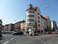
Sündersbühl is a district in the further inner city belt west of Nuremberg , the name of the statistical district 21 and the district number 3470 .
geography
The statistical district Sündersbühl borders in the west along the federal highway 4 R on Gaismannshof , in the south on Rothenburger Straße on St. Leonhard and on the Frankenschnellweg in the northeast on Gostenhof .
The northeastern part of Sünderbühl, along Fugger and Witschelstrasse, is characterized by car trading and other businesses. In the southern part there is a residential area with multi-storey buildings along Rothenburger Strasse and Ossietzkystrasse. In between, in the west of the district, is the eastern part of the West Park and an allotment garden.
| Neighboring statistical districts | |||||||||
|---|---|---|---|---|---|---|---|---|---|
|
.svg)
history
The place was first mentioned in 1362 as "Sinterspuehel". The name Sinterspuehel is derived from Sinter (hammer blow, metal slag) and Bühl (hill).
The feud Sündersbühl that one third of the Bishopric of Bamberg was awarded and two-thirds of the local Dompropstei, should by the annals of John Muellner about 1340 by a marriage of the Staudigl the Nützel have come a Nuremberg patrician family , probably by the marriage of Konrad Nutzel.
- The Usefulelschlösschen , burned down by the margravial troops in 1449 and rebuilt from 1516, destroyed again in the Second Margrave War in 1552 and renewed at the end of the 16th century, again devastated in the Thirty Years War 1632/34 by the "Tilly peoples" and restored in the 1680s , remained in the possession of the Nutzel von Sündersbühl until it died out in 1747. The estate fell back to the feudal lords, which triggered lawsuits with the Nutzel's heirs. In 1774, the bishopric and the Bamberg cathedral provost sold the entire feudal complex with bailiwick, village and community rule, additional tax and change as a man fief for 25,000 guilders to Johann Sigmund Haller von Hallerstein . The imperial city is said to have added 4,000 guilders to the purchase price so that the Bamberg lordship could come back into Nuremberg hands. At the beginning of the 19th century, the mansion was still surrounded by a moat or “weyher”, which was spanned by a wooden bridge that was renewed in 1779. In addition, the seat including the “Rupprechtschlösschen” and the large garden were enclosed by a wall. The latter disappeared as early as 1880, and in the 19th century, the Small Useful Palace came into changing hands and in 1873 to the city of Nuremberg, which planned the construction of the slaughterhouse on the site. The castle was used as a poor house and later by the neighboring slaughterhouse and destroyed in 1943 during World War II.
- The Burgfriedschlösschen was originally a keep (actually more of a residential tower ) that stood in a pond, and in 1360 it came to the Pfinzing , then to the Stromer and in 1391 to Conrad Kötzner. The Holzschuher followed in 1467, the Imhoff in 1502 , and from 1588 on, changing citizens. From 1614 Carl Wertemann expanded the ruins into a representative mansion. The Wertemann trading house is said to have gone bankrupt as early as 1607 after risky financial deals with the Reichspfennigmeister Matthäus Welser , whereby two family members died under mysterious circumstances in 1608 and the mansion was looted soon after. The large manor house was destroyed by the Tilly mercenaries in 1632/34 and only an outbuilding was rebuilt. This came into changing hands, was damaged in bombing raids in World War II and demolished in the years after 1945.
At the end of the 18th century there were 21 properties in Sündersbühl. The high court exercised the Brandenburg-Ansbach Oberamt Cadolzburg , but this was disputed by the imperial city of Nuremberg . The Nuremberg owners von Haller ruled the village and community . The landlords were the Chamber Councilor Hofmann zu Vach (1 castle, 1 courtyard, 1 Seldengut, 2 houses) and Nuremberg owners : von Grundherr (1 house), von Haller (1 castle, 3 courtyards, 6 estates, 4 estates, community pastoral house), von Scheurl (1 little farm).
As part of the municipal edict , the Sündersbühl tax district was formed in 1808 , which included Bleiweißgarten , Deutschherrnbleiche , Himpfelshof , Kleinweidenmühle , Spitzgarten , St. Leonhard and stables in front of the Spittlertor . In the same year the rural community Sündersbühl was formed, which was congruent with the tax district. In administration and jurisdiction it was subordinate to the Regional Court of Nuremberg and in financial administration to the Fürth Rent Office . In voluntary jurisdiction, 1 property was subject to the Fischbach Patrimonial Court from 1822 to 1848 and 9 properties to the Großgründlach Patrimonial Court until 1823 . In 1825 Bleiweißgarten, Deutschherrnbleiche, Himpfelshof, Kleinweidenmühle, Spitzgarten and stables in front of the Spittlertor were incorporated into Nuremberg. From 1862 Sündersbühl was administered by the Nuremberg District Office . Jurisdiction has been with the Nuremberg District Court since 1880 . The financial management was taken over in 1871 by the Nuremberg Rent Office ( renamed the Nuremberg Tax Office in 1920 ). In 1885 the municipality had an area of 1.666 km². On January 1, 1898, Sündersbühl was incorporated into Nuremberg .
Architectural monuments
- Factory owner's villa
- Former management building of the Ernst Meck tin goods factory
- Former Hörmann manor house
- Carl von Ossietzky School
- Memorial plaque for Johann Georg Hoffmann
- Tenement houses
Population development
Sündersbühl municipality
| year | 1818 | 1840 | 1852 | 1855 | 1861 | 1867 | 1871 | 1875 | 1880 | 1885 | 1890 | 1895 | 1900 |
|---|---|---|---|---|---|---|---|---|---|---|---|---|---|
| Residents | 599 | 473 | 520 | 495 | 564 | 733 | 756 | 1383 | 2033 | 2168 | 2858 | 3871 | 7180 |
| Houses | 84 | 44 | 63 | 139 | 286 | ||||||||
| source |
Location Sündersbühl
| year | 1818 | 1840 | 1861 | 1871 | 1885 |
|---|---|---|---|---|---|
| Residents | 199 | 356 | 564 * | 522 | 341 |
| Houses | 33 | 34 | 28 | ||
| source |
religion
The place has been predominantly Protestant since the Reformation. The residents of the Evangelical Lutheran denomination are parish to St. Leonhard , the residents of the Roman Catholic denomination are parish to St. Boniface .
photos

The Frankenschnellweg on the corner of Rothenburger Strasse and Pfinzingstrasse in the far east of the district

Apartment building with clinker brick facade on the corner of Holzschuherstrasse and Rosenplütstrasse

The properties Wolgemutstrasse 1 to 7 and Holzschuherstrasse 8 to 12 in the east of Sündersbühl

The McFIT branch Gostenhof in Wolgemutstraße 2
Rothenburger Strasse at the confluence with Fuggerstrasse

The properties at Holzschuherstrasse 22 to 26

Historic style villa in Holzschuherstraße 9

Entrance to a hobby workshop and tango academy in Holzschuherstrasse 11 and 13

The Europa Club eV in Holzschuherstraße 4

Row of houses on the northwestern, Sündersbühler side of Rothenburger Straße with addresses 128 to 140

Wilhelminian style house with sandstone facade and three-story bay window at Holzschuherstraße 20

The "Insel-Bistro" near the Sündersbühl underground station at Rothenburger Straße 210

View into a back yard at Holzschuherstrasse 22
The Pizzeria Milano in Rothenburger Straße 144 opposite the junction with Schweinauer Straße

McFIT Gostenhof in Wolgemutstrasse 2

North side of Holzschuherstraße in its eastern section with the numbers 2 to 16

The "Café am Eck" in Holzschuherstrasse 2


See also
literature
- Johann Kaspar Bundschuh : Sündersbühl . In: Geographical Statistical-Topographical Lexicon of Franconia . tape 5 : S-U . Verlag der Stettinische Buchhandlung, Ulm 1802, DNB 790364328 , OCLC 833753112 , Sp. 478 ( digitized version ).
- Hanns Hubert Hofmann : Nuremberg-Fürth (= Historical Atlas of Bavaria, part Franconia I, 4). Commission for Bavarian State History, Munich 1954, DNB 452071224 , p. 176 ( digitized version ). Ibid. S. 244 ( digitized version ).
- Gustav Voit: Sündersbühl . In: Michael Diefenbacher , Rudolf Endres (Hrsg.): Stadtlexikon Nürnberg . 2nd, improved edition. W. Tümmels Verlag, Nuremberg 2000, ISBN 3-921590-69-8 , p. 1059 ( online ).
Web links
- Sündersbühl in the historical directory of the association for computer genealogy
- District data sheet Nuremberg - Statistical District 21 Sündersbühl , as of 2015 (PDF; approx. 120 kB)
Individual evidence
- ^ City of Nuremberg, Office for Urban Research and Statistics for Nuremberg and Fürth (ed.): Statistical Yearbook of the City of Nuremberg 2016 . December 2015, ISSN 0944-1514 , 18 Statistical City Districts and Districts, p. 244–245 , p. 244 ( nuernberg.de [PDF; 6.3 MB ; accessed on November 1, 2017]).
- ↑ chap. 18: Statistical city districts and districts ( Memento of the original from April 19, 2011 in the Internet Archive ) Info: The archive link was inserted automatically and has not yet been checked. Please check the original and archive link according to the instructions and then remove this notice. (PDF; 4.6 MB) at archiv.statistik.nuernberg.de
- ^ City map service of the city of Nuremberg , accessed January 25, 2010
- ↑ Sündersbühl in the Bavaria Atlas
- ↑ G. Voit, p. 1059.
- ↑ History according to Herrensitze.com (Giersch / Schlunk / von Haller)
- ↑ Sündersbühl on herrensitze.com
- ↑ HH Hofmann, p. 176.
- ↑ HH Hofmann, p. 244; Address and statistical handbook for the Rezatkreis in the Kingdom of Baiern . Buchdruckerei Chancellery, Ansbach 1820, p. 63 ( digitized version ).
- ↑ a b c K. Bayer. Statistical Bureau (Ed.): Localities directory of the Kingdom of Bavaria. According to government districts, administrative districts, ... then with an alphabetical register of locations, including the property and the responsible administrative district for each location. LIV. Issue of the contributions to the statistics of the Kingdom of Bavaria. Munich 1888, Section III, Sp. 1166 ( digitized version ).
- ^ Wilhelm Volkert (ed.): Handbook of Bavarian offices, communities and courts 1799–1980 . CH Beck, Munich 1983, ISBN 3-406-09669-7 , p. 602 .
- ↑ a b Only inhabited houses are given. In 1818 these are known as fireplaces , in 1840 as houses , and from 1871 to 1900 as residential buildings.
- ↑ a b Alphabetical index of all the localities contained in the Rezatkreise according to its constitution by the newest organization: with indication of a. the tax districts, b. Judicial Districts, c. Rent offices in which they are located, then several other statistical notes . Ansbach 1818, p. 90 ( digitized version ). For the community of Sündersbühl plus the residents and buildings of Bärenschanze (p. 7), Himpfelshof (p. 40), Kleinweidenmühle (p. 49), St. Leonhard (p. 79) and Teutschherrnbleiche (p. 91).
- ^ A b Eduard Vetter (Ed.): Statistical handbook and address book of Middle Franconia in the Kingdom of Bavaria . Self-published, Ansbach 1846, p. 209 ( digitized version ). According to the historical municipality register , the municipality had 429 inhabitants.
- ↑ a b c d e f g Bavarian State Statistical Office (Hrsg.): Historical municipality register: The population of the municipalities of Bavaria in the period from 1840 to 1952 (= contributions to Statistics Bavaria . Issue 192). Munich 1954, DNB 451478568 , p. 181 , urn : nbn: de: bvb: 12-bsb00066439-3 ( digital copy ).
- ↑ a b Joseph Heyberger, Chr. Schmitt, v. Wachter: Topographical-statistical manual of the Kingdom of Bavaria with an alphabetical local dictionary . In: K. Bayer. Statistical Bureau (Ed.): Bavaria. Regional and folklore of the Kingdom of Bavaria . tape 5 . Literary and artistic establishment of the JG Cotta'schen Buchhandlung, Munich 1867, Sp. 1066 , urn : nbn: de: bvb: 12-bsb10374496-4 ( digitized ).
- ↑ a b Kgl. Statistical Bureau (ed.): Complete list of localities of the Kingdom of Bavaria. According to districts, administrative districts, court districts and municipalities, including parish, school and post office affiliation ... with an alphabetical general register containing the population according to the results of the census of December 1, 1875 . Adolf Ackermann, Munich 1877, 2nd section (population figures from 1871, cattle figures from 1873), Sp. 1232 , urn : nbn: de: bvb: 12-bsb00052489-4 ( digitized version ).
- ↑ K. Bayer. Statistical Bureau (Ed.): Directory of localities of the Kingdom of Bavaria, with alphabetical register of places . LXV. Issue of the contributions to the statistics of the Kingdom of Bavaria. Munich 1904, Section II, Sp. 1146 ( digitized version ). At this point in time, the community was already incorporated into Nuremberg.
.svg)
.svg)
Almoshof | Altenfurt | Bärenschanze | Pearwood | White lead | Boxing Village | Brunn | Book | Buchenbühl | Doos | Dutzendteich | Eberhardshof | Eibach | Eibacher Forest | Erlenstegen | Falkenheim | Fischbach | Open air settlement | Gaismannshof | Galgenhof | Gardens near Wöhrd | Gardens behind the fortress | Garden city | Gaulnhofen | Gebersdorf | Gerasmühle | Gibitzenhof | Gleißbühl | Gleißhammer | Glockenhof | Gostenhof | Greuth | Großgründlach | Großreuth near Schweinau | Großreuth behind the fortress | Gugelstrasse | Guntherstrasse | Hammer | Hasenbuck | Herpersdorf | Herrnhütte | Himpfelshof | Holzheim | Courtyards | Courtly | Hummelstein | St. Jobst | St. Johannis | Katzwang | Kettelersiedlung | Kleingründlach | Kleinreuth near Schweinau | Kleinreuth behind the fortress | Kleinweidenmühle | Klingenhof | Royal court | Koppenhof | Kornburg | Powerhouse | Settlement of war sacrifices | Krottenbach | Long water | Laufamholz | St. Leonhard | Leyh | Lichtenhof | Tan | Loher Moos | Lohhof | Lorenz | Ludwigsfeld | Maiach | Marienberg | Marienvorstadt | Maxfeld | Middle mill | Mögeldorf | Moorenbrunn | Mooshof | Muggenhof | Mühlhof | Net stall | Neukatzwang | Neulandsiedlung | Neunhof | Neuröthenbach | Neuselsbrunn | North Station | Northeast Station | Oberbürg | Obermühle | St. Peter | Pillenreuth | Pirckheimerstrasse | Rabus | Marshalling yard settlement | Rechenberg | Rehhof | Reichelsdorf | Reichelsdorfer Keller | Rennweg | Reutles | Rosenau | Röthenbach near Schweinau | Sandberg | Sandreuth | Sheep farm | Schmalau | Schnepfenreuth | Schniegling | Schoppershof | Schweinau | Sebald | Seeleinsbühl | Spitalhof | Quarries | Steinbühl | Stone slab | Sündersbühl | Tafelhof | Clay | Tullnau | Lower guarantee | Veilhof | Vistula Garden | Weigelshof | Weiherhaus | Werderau | Westfriedhof | Wetzendorf | Wöhrd | Worzeldorf | Zerzabelshof | Brick | Customs House
(0) Old town and closer inner city : (01) Old town, St. Lorenz | (02) Marienvorstadt | (03) Tafelhof | (04) Gostenhof | (05) Himpfelshof | (06) Old Town, St. Sebald | (07) St. Johannis | (08) Pirckheimerstraße | (09) Wöhrd • (1) Further inner city belt south : (10) Ludwigsfeld | (11) Glockenhof | (12) Guntherstrasse | (13) Galgenhof | (14) Hummelstein | (15) Gugelstrasse | (16) Steinbühl | (17) Gibitzenhof | (18) Sandreuth | (19) Schweinau • (2) Further inner city belt west / north / east : (20) St. Leonhard | (21) Sündersbühl | (22) Bärenschanze | (23) Sandberg | (24) Bielingplatz | (25) Uhlandstrasse | (26) Maxfeld | (27) Veilhof | (28) Tullnau | (29) Gleißhammer • (3) Southeastern outer city : (30) Dutzendteich | (31) Marshalling yard settlement | (32) Langwasser Northwest | (33) Langwasser Northeast | (34) Beuthener Strasse | (35) Altenfurt North | (36) Langwasser Southeast | (37) Langwasser Southwest | (38) Altenfurt, Moorenbrunn | (39) Nuremberg-Feucht business park • (4) Southern outer city : (40) Hasenbuck | (41) Marshalling yard | (42) Katzwanger Strasse | (43) Dianastraße | (44) Trier Street | (45) Garden City | (46) Werderau | (47) Maiach | (48) Katzwang, Reichelsdorf Ost, Reichelsdorfer Keller | (49) Kornburg, Worzeldorf • (5) South-western outskirts : (50) Hohe Marter | (51) Röthenbach West | (52) Röthenbach Ost | (53) Eibach | (54) Reichelsdorf | (55) Krottenbach, Mühlhof • (6) Western outer city : (60) Großreuth near Schweinau | (61) Gebersdorf | (62) Gaismannshof | (63) Courts | (64) Eberhardshof | (65) Muggenhof • (7) Northwest outer city : (70) Westfriedhof | (71) Schniegling | (72) Wetzendorf | (73) book | (74) clay | (75) Almoshof | (76) Kraftshof | (77) Neunhof | (78) Boxdorf | (79) Großgründlach • (8) Northeastern outer city : (80) Schleifweg | (81) Schoppershof | (82) Sheep Farm | (83) Marienberg | (84) brick | (85) Mooshof | (86) Buchenbühl | (87) Airport • (9) East outer city : (90) St. Jobst | (91) Erlenstegen | (92) Mögeldorf | (93) Schmausenbuckstrasse | (94) Laufamholz | (95) Zerzabelshof | (96) Fischbach | (97) Well