
Netzstall (Nuremberg)
|
Netzstall
Statistical District 971 City of Nuremberg
Coordinates: 49 ° 25 ′ 35 ″ N , 11 ° 15 ′ 16 ″ E
|
|
|---|---|
| Height : | 370 m above sea level NN |
| Residents : | 20th |
| Incorporation : | July 1, 1972 |
| Postal code : | 90475 |
| Area code : | 0911 |
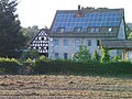
.jpg) The hamlet Netzstall belonging to the city of Nuremberg
|
|
The Middle Franconian hamlet Netzstall is a district of the city of Nuremberg with approx. 20 inhabitants located in the Nuremberg Reichswald . Together with the nearby towns of Brunn and Birnthon , it forms the statistical district 97 of the Nuremberg city area.
geography
Netzstall is located about thirteen kilometers south-south-east of Nuremberg city center, in the middle of a clearing that is surrounded by the Lorenzer Reichswald . The closest settlement is Brunn, one kilometer further north. Almost two kilometers northwest of the hamlet rises the 438 meter high Brunner Berg .
Together with Brunn and Birnthon, Netzstall lies in a section of the Lorenzer Reichswald, which is completely delimited by the routes of the three federal motorways A 3 , A 6 and A 9 . The forest area enclosed in this way represents an almost isosceles triangle, the geographical center of which is roughly formed by the 395 meter high Netzstaller Rangen , a wooded elevation that is about one kilometer west-southwest of the hamlet.
The Ludergraben runs east of Netzstall .
history
Netzstall was first mentioned in 1360, when it came into the possession of the Zollern Burgraviate of Nuremberg together with some goods in Brunn as an imperial fief . Until the municipal territorial reform , Netzstall had belonged to the until then independent municipality of Brunn, since its incorporation into the city of Nuremberg in 1972, it has been one of the three inhabited exclaves of Nuremberg that are located within the district of Nürnberger Land .
traffic
The town is connected to the public road network by an approximately one-kilometer-long cul-de-sac that branches off the Fischbach - Leinburg road on the eastern outskirts of Brunn . Netzstall is not served by the VAG urban transport network; the nearest stop is the final stop on city bus 54 in the eastern part of Brunn .
Economy and trade
There is a farm and a riding stables in Netzstall. There are no shops or restaurants there.
Worth seeing in nature
- The Fed Graben near Ungelstetten
- The Röthenbachklamm near Ungelstetten
- The birch lake
- The Hautastein stone cross near Fischbach
Picture gallery

The courtyards of the hamlet of Netzstall

The transformer station in the village

Farm in net stable
Riding stables in net stable
.jpg)
.jpg)


literature
- Michael Diefenbacher , Rudolf Endres (Hrsg.): Stadtlexikon Nürnberg . 2nd, improved edition. W. Tümmels Verlag, Nuremberg 2000, ISBN 3-921590-69-8 ( online ).
- Altnürnberger Landschaft eV (Hrsg.): Castles and mansions in the Nuremberg countryside . 1st edition. Self-published by Altnürnberger Landschaft eV, Lauf an der Pegnitz 2006, ISBN 978-3-00-020677-1 .
Web links
- Location of Netzstall in the BayernAtlas (accessed on October 16, 2016)
.svg)
.svg)
Almoshof | Altenfurt | Bärenschanze | Pearwood | White lead | Boxing Village | Brunn | Book | Buchenbühl | Doos | Dutzendteich | Eberhardshof | Eibach | Eibacher Forest | Erlenstegen | Falkenheim | Fischbach | Open air settlement | Gaismannshof | Galgenhof | Gardens near Wöhrd | Gardens behind the fortress | Garden city | Gaulnhofen | Gebersdorf | Gerasmühle | Gibitzenhof | Gleißbühl | Gleißhammer | Glockenhof | Gostenhof | Greuth | Großgründlach | Großreuth near Schweinau | Großreuth behind the fortress | Gugelstrasse | Guntherstrasse | Hammer | Hasenbuck | Herpersdorf | Herrnhütte | Himpfelshof | Holzheim | Courtyards | Courtly | Hummelstein | St. Jobst | St. Johannis | Katzwang | Kettelersiedlung | Kleingründlach | Kleinreuth near Schweinau | Kleinreuth behind the fortress | Kleinweidenmühle | Klingenhof | Royal court | Koppenhof | Kornburg | Powerhouse | Settlement of war sacrifices | Krottenbach | Long water | Laufamholz | St. Leonhard | Leyh | Lichtenhof | Tan | Loher Moos | Lohhof | Lorenz | Ludwigsfeld | Maiach | Marienberg | Marienvorstadt | Maxfeld | Middle mill | Mögeldorf | Moorenbrunn | Mooshof | Muggenhof | Mühlhof | Net stall | Neukatzwang | Neulandsiedlung | Neunhof | Neuröthenbach | Neuselsbrunn | North Station | Northeast Station | Oberbürg | Obermühle | St. Peter | Pillenreuth | Pirckheimerstrasse | Rabus | Marshalling yard settlement | Rechenberg | Rehhof | Reichelsdorf | Reichelsdorfer Keller | Rennweg | Reutles | Rosenau | Röthenbach near Schweinau | Sandberg | Sandreuth | Sheep farm | Schmalau | Schnepfenreuth | Schniegling | Schoppershof | Schweinau | Sebald | Seeleinsbühl | Spitalhof | Quarries | Steinbühl | Stone slab | Sündersbühl | Tafelhof | Clay | Tullnau | Lower guarantee | Veilhof | Vistula Garden | Weigelshof | Weiherhaus | Werderau | Westfriedhof | Wetzendorf | Wöhrd | Worzeldorf | Zerzabelshof | Brick | Customs House