
Mögeldorf
|
Mögeldorf
Statistical District 92 City of Nuremberg
Coordinates: 49 ° 27 '34 " N , 11 ° 7' 55" E
|
|
|---|---|
| Height : | 313-316 m above sea level NHN |
| Area : | 1.71 km² |
| Residents : | 5566 (Dec. 31, 2015) |
| Population density : | 3,249 inhabitants / km² |
| Incorporation : | January 1, 1899 |
| Postcodes : | 90480, 90482 |
| Area code : | 0911 |
 Location of the statistical district 92 Mögeldorf in Nuremberg
|
|
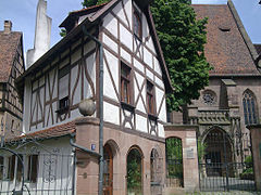
 Evang. Church of St. Nicholas and Ulrich
|
|
Mögeldorf has been a district of Nuremberg in the eastern outer city since 1899 (statistical district 92), the name of the district 3445 and is one of the districts of Nuremberg worth seeing.
geography
Mögeldorf is located in the east of the city and is bordered by the Ringstrasse to the west, by the Wöhrder See and Pegnitz to the north and by the Lorenzer Reichswald to the south . Neighboring towns are the Nuremberg districts of St. Jobst , Erlenstegen , Unterbürg , Laufamholz , Rehhof , Zerzabelshof and Tullnau as well as the non-community area Laufamholzer Forst in the Lorenzer Reichswald.
| Neighboring statistical districts | |||||||||
|---|---|---|---|---|---|---|---|---|---|
|
.svg)
Statistical Districts
District 92 Mögeldorf
| Statistical districts of the district 92 Mögeldorf | |||||||||
|---|---|---|---|---|---|---|---|---|---|
 |
|||||||||
|
District 92 Mögeldorf consists of the following districts:
- 920 - Mögeldorf (industrial area Ostendstrasse)
- 921 - Mögeldorf (Mögeldorfer Hauptstr.)
- 922 - Mögeldorf (Ziegenstrasse)
- 923 - Mögeldorf (Ebenreuther Str.)
- 924 - Mögeldorf (industrial area Rehofstr.)
- 925 - Mögeldorf (Freiligrath-Str. Industrial area)
District 93 Schmausenbuckstrasse
The district 93 Schmausenbuckstraße consists of the following districts:
- 930 - Mögeldorf (Dientzenhoferstr.)
- 931 - Mögeldorf (Balthasar-Neumann-Str.)
- 932 - Mögeldorf (Thäterstr.)
history

The place was first mentioned in a document on May 6, 1025 as "Megelendorf" and is therefore older than Nuremberg itself. The place was initially a fortified farm on a Pegnitzfurt, through which several old streets led. It served King Conrad II as a branch of his court. On his travels from Regensburg to Bamberg, the ruler "notarized" in Mögeldorf in 1025 and 1030. 1200 appears for the first time as a high-ranking Reich Ministerial Reimarus of "Meglindorf", probably from the Laufamholzer family (see Unterbürg ); in 1213 he held the office of Nuremberg groom. The royal court and imperial ministerial seat are presumed to be in the area of the Mögeldorfer Kirchhof and the neighboring Hallerschloss to the west. In the course of the late Middle Ages and early modern times, a total of seven mansions were built in the village, some of them from families of the Nuremberg patriciate , five of which have survived. In addition to Erlenstegen, Mögeldorf had the highest density of stately homes in the old Nuremberg countryside.
In addition to farmers and the usual craftsmen, several stone cutters who worked in the nearby quarries settled down later . In the Middle Ages and the Renaissance , several Nuremberg patrician families built country estates here on the Kirchenberg, idyllically situated above the Pegnitz, some of which are still preserved today. In 1561 a paper mill was built, which later became the art mill of the Satzinger family.
At the end of the 18th century there were 63 properties in Mögeldorf. The high court exercised the imperial city of Nuremberg , but this was contested by the Brandenburg-Ansbach Oberamt Schwabach and the Brandenburg-Bayreuth Vogtamt Schönberg . The Landpflegamt Nürnberg was in charge of the village and community . The landlords were the Vogtamt Schönberg (1 farm, 2 half farms, 1 estate, 7 farms, 1 house, 1 game management); the imperial city of Nuremberg: Landpflegamt (church, rectory, schoolhouse, parish servant's apartment, shepherd's house, fire house), Laurenzi forest office (1 courtyard, 10 houses); Nuremberg owners: von Ebner (1 house), von Fürer (3 houses), von Haller (2 Gütlein), von Holzschuher (1 manor, 1 half-yard, 2 estates, 1 Gütlein, 1 house), von Imhoff (1 manor, 3 Houses), vonöffelholz (2 mansions, 1 estate, 1 estate, 3 houses), von Petz (1 yard, 1 half yard), von Scheidlin (1 estate, 1 estate, 1 estate, 1 house), von Tucher (2 estate ); Freiherr von Egloffstein (2 half yards, 1 little farm).

As part of the municipal edict, the Mögeldorf tax district was formed in 1808 , to which Schmausenbuck , Valznerweiher and Zerzabelshof belonged. In the same year the rural community Mögeldorf was formed, which was congruent with the tax district. In administration and jurisdiction it was subordinate to the Regional Court of Nuremberg and in financial administration to the Fürth Rent Office . In voluntary jurisdiction, 4 properties from 1825 to 1835 were subject to the Patrimonial Court (PG) Gibitzenhof , 2 properties until 1823 to the PG Großgründlach , 3 properties from 1822 to 1836 to the PG Haimendorf , 3 properties from 1820 to 1848 to the PG Kornburg , 2 properties from 1822 until 1835 the PG Lohe and Behringersdorf and 1 property until 1812 and from 1820 to 1848 the PG Lichtenhof . After 1818, but before 1840, Zerzabelshof split up with Valznerweiher and formed its own rural community. Rehhof was founded in the second half of the 19th century in the municipality of Mögeldorf. From 1862 Mögeldorf was administered by the Nuremberg District Office . Jurisdiction has been with the Nuremberg District Court since 1880 . The financial management was taken over in 1871 by the Nuremberg Rent Office ( renamed the Nuremberg Tax Office in 1920 ). The municipality had an area of 3.675 km². On January 1, 1899 Mögeldorf was incorporated into Nuremberg .
In modern times, Mögeldorf has remained true to its tradition as an upscale residential area and, along with Erlenstegen on the opposite bank of the Pegnitz, is now one of the best residential areas in Nuremberg. The green Pegnitztal with the Wöhrder See, the nearby Reichswald and the Schmausenbuck with the zoo guarantee the high recreational value.
Population development
Mögeldorf community
| year | 1818 | 1840 | 1852 | 1855 | 1861 | 1867 | 1871 | 1875 | 1880 | 1885 | 1890 | 1895 | 1900 |
|---|---|---|---|---|---|---|---|---|---|---|---|---|---|
| Residents | 743 | 766 | 949 | 967 | 1087 | 1262 | 1526 | 1736 | 1805 | 1986 | 2175 | 2414 | 3141 |
| Houses | 97 | 83 | 159 | 211 | 268 | ||||||||
| source |
Place Mögeldorf
| year | 1818 | 1840 | 1861 | 1871 | 1885 |
|---|---|---|---|---|---|
| Residents | 621 | 755 | 1066 | 1507 | 1967 |
| Houses | 75 | 81 | 207 | ||
| source |
religion
The place has been predominantly Protestant since the Reformation. The residents of the Evangelical Lutheran denomination are parish according to St. Nicholas and Ulrich , the residents of the Roman Catholic denomination are parish according to St. Karl Borromeo .
Attractions
The Gothic church of St. Nikolaus and Ulrich and the Protestant parish church of Mögeldorf, with the surrounding cemetery, are worth seeing . The Catholic parish church of St. Karl Borromeo , which was built in the Expressionism style in 1926/27 , is also a registered monument .
Five of the former seven mansions are still preserved. They belonged to wealthy Nuremberg bourgeois families, some of them patricians , and often changed hands:
- The "Hallerschloss" (Kirchenberg 7–11) is a residential tower with slotted windows from the 13th / 14th centuries in the southwestern part . Century, which was extended to the east in the early modern period and topped with half-timbered buildings around 1500. At the end of the 17th century, the tall building lost its hipped roof and received a gable roof and half-timbered gable windows. In the 13th century, the Zollerischen burgraves of Nuremberg ousted the former Reichsministeriale von Lauffenholtz (Laufamholz) and claimed the rights to the small castle on the former Könisghof. However, the Laufamholzers retained feudal rights in Mögeldorf until they died out in 1568. In the second half of the 15th century, Hans Tetzel acquired the seat; In 1482 he had to undertake to sell the dwelling in Mögeldorf, which he “erect and pau” in agreement with the Nuremberg council, “and the ytzo in the paw stee” , in future only to the citizens of Nuremberg, because the council does not offer an open house for the Hohenzollern family wanted to have the gates of the city. The Feste Haus then came to Augsburg entrepreneurs Anton and Lukas Grander in 1515, presumably as a trading establishment outside the imperial city, from whom Hieronymus Rehlinger , also an Augsburg entrepreneur, acquired it. He sold it in 1555 to Wolf VIII. Haller von Hallerstein , Reichspfennigmeister of Emperor Charles V (1492–1559) and thus to a Nuremberg patrician family. In 1666 it fell to the Altdorf nurse Georg Andreas Imhoff , whose family kept it for 140 years.
- In 1691, the "Imhoff building" was converted from a barn in the Hallerschloss to a second residential building, which was only separated from the Hallerschloss in 1857.
- The "Baderschloss" (Mögeldorfer Hauptstraße 55) was first built in 1579 and then again from 1612. A renovation from 1795 under the Imhoff characterizes today's appearance. It got its name from the Bader Eberhard Leopold, who bought it in 1810.
- The "Schmausenschloss" (Ziegenstrasse 12-20) is named after the red beer brewer Georg Schmaus, who acquired the property in 1667 and built a new one instead of an older one. Only his daughter Anna Susanne had a new manor house and a magnificent baroque garden built some distance away in 1682, to which a coach house was added in 1692.
- The "Cnopfsche or Lincksche Schloss" (Ziegenstrasse 3–5) emerged from a farm in the early 16th century. In the 17th and early 18th centuries it was rebuilt several times and modernized in a historicizing way from 1878 to around 1880, whereby it received the characteristic wooden corner turrets and dormers. To the north there is a defensive wall set on the steep slope with the remains of a battlement. It got its name from the pharmacist Johann Jakob Christoph Cnopf, who bought it in 1788 and had it renovated, and from the manufacturer Carolus Linck, who bought it in 1936.
- The "Lincksche Haus" (Schmausenbuckstraße 14) was founded around 1710 by Dr. Martin Linck (presumably from the Nuremberg family of lawyers) built as a small summer residence in a garden that was famous for its bitter orange grove as early as 1700 . The Gütle was under the lordship of the family Löffelholz and was probably granted as an inheritance loan. The building is now an inn.
- The "Bremensitz" (Kinkelstrasse 2), built in 1574 by the merchant Anthony Brem, was replaced in 1916 by a multi-storey residential building.
- The "Doctor castle" (Mögeldorfer main road 31-39), a three-storey Sandsteinquaderbau with corner towers, which dated back to the 14th century and owned by the Ebner and Holzschuher was, was canceled in 1972 to shortly before the entry into force of the Bavarian Monument Protection Act to build a to enable modern residential complex.
A walk down to the Pegnitz Valley, past the Satzinger mill (named after Michael Satzinger in 1869 ) and along the shores of Lake Wöhrder is also worthwhile . There is a nature experience path with over 20 stations. A little south of Mögeldorf, in the neighboring district of Zerzabelshof, is the Nuremberg Zoo, one of the largest zoos in Germany. On the western edge of the district (towards downtown) is the Business Tower of Nuremberg .

Haller Castle
Outbuilding of the Hallerschloss

Imhoff 's construction

Baderschloss

Feast lock

Cnopf's or Linck's lock

Linck's house

Ev. Church of St. Nicholas and Ulrich

Former forge

Bakery


.jpg)
.jpg)


Infrastructure
Mögeldorf has a good local supply with a supermarket and numerous small shops and inns in the old town center.
Through the district of the starting of the ring road extends from West to East State Road 2241 (Nürnberg-Hiltpoltstein) as Ostend- and Laufamholzstraße that Mögeldorf with the A 3 at the junction Nürnberg-Mögeldorf connects. The Nürnberg-Mögeldorf station is located on the Nuremberg – Schwandorf railway line from east to west and is served exclusively by the S1 S-Bahn line . This takes you to the main train station in around six to seven minutes . Mögeldorf is served by tram line 5, which joins city bus lines 40, 45 and 95 at the Mögeldorf stop (at the “Mögeldorfer Plärrer”) .
Personalities
- Peter Horst Neumann (1936–2009), poet, essayist and literary scholar, 1983–2001 professor at the Friedrich-Alexander-Universität Erlangen-Nürnberg , lived in Mögeldorf
- Andreas Köpke (* 1962), former German soccer player, lives in Mögeldorf
- Markus Söder (* 1967), CSU politician and Bavarian Prime Minister, lives in Mögeldorf
literature
- Leo Beyer: The Nuremberg district Mögeldorf. A house story . Nuremberg: Spindler, 1964. - 454 pages, (Free series of publications by the Arbeitsgemeinschaft für Belange und Geschichte Mögeldorfs eV; Vol. 2) IDN: 450439569
- Johann Kaspar Bundschuh : Mögeldorf . In: Geographical Statistical-Topographical Lexicon of Franconia . tape 3 : I-Ne . Verlag der Stettinische Buchhandlung, Ulm 1801, DNB 790364301 , OCLC 833753092 , Sp. 634 ( digitized version ).
- Günther P. Fehring , Anton Ress , Wilhelm Schwemmer: The city of Nuremberg (= Bavarian art monuments . Volume 10 ). 2nd Edition. Deutscher Kunstverlag, Munich 1977, ISBN 3-422-00550-1 , p. 378-387 .
- Hanns Hubert Hofmann : Nuremberg-Fürth (= Historical Atlas of Bavaria, part Franconia I, 4). Commission for Bavarian State History, Munich 1954, DNB 452071224 , p. 140-141 ( digitized version ). Ibid. S. 242 ( digitized version ).
- Franz Flierl: Mögeldorf - its history, its streets . [Ed .: Working group for concerns u. History of Mögeldorfs e. V.]. - [Mögeldorf]: Working group for concerns u. History of Mögeldorfs, 1985. - 192 p., IDN: 880858583 - (series of publications by the Arbeitsgemeinschaft für Belange und Geschichte Mögeldorfs eV; Vol. 4)
- Gerhard Kindler: Mögeldorf then and now, a. Illustrated book . [Ed .: Working group for concerns u. History of Mögeldorf]. - Mögeldorf: Working group for concerns u. History of Mögeldorfs, 1978. - 213 pages (series of publications by the Arbeitsgemeinschaft für Belange und Geschichte Mögeldorfs eV; Vol. 3) IDN: 790532638
- Citizens and History Association Mögeldorf e. V. (Hrsg.): Mögeldorf - a foray through history . 1st edition, Nuremberg district books No. 5, Nuremberg: Sandberg-Verlag, 2000, 239 pages, ISBN 3-930699-18-4
- Hermann Rusam: Mögeldorf . In: Michael Diefenbacher , Rudolf Endres (Hrsg.): Stadtlexikon Nürnberg . 2nd, improved edition. W. Tümmels Verlag, Nuremberg 2000, ISBN 3-921590-69-8 , p. 698 ( online ).
- Hermann Rusam: Mögeldorf . Special print, Nuremberg: Korn and Berg, 1990, 32 pages, ISBN 3-87432-121-5
- Hermann Rusam: The structural development of the old town center of Mögeldorf . In: Messages from the Altnürnberger Landschaft e. V., 1990, No. 1, pp. 181-200
- Barbara Schock-Werner: Nuremberg-Mögeldorf, St. Karl Borromeo . [Photos: Reinhard Bruckner]. 1st edition, Art Guide No. 1991, Munich; Zurich: Schnell and Steiner, 1993, 19 p., Numerous. Ill., Graph. Darst .; IDN: 944253784
- Pleikard Joseph Stumpf : Mögeldorf . In: Bavaria: a geographical-statistical-historical handbook of the kingdom; for the Bavarian people . Second part. Munich 1853, p. 747 ( digitized version ).
Web links
- Mögeldorf in the historical directory of the association for computer genealogy
- Citizens and History Association Mögeldorf e. V.
- First documentary mention
- History of Mögeldorf
Individual evidence
- ^ City of Nuremberg, Office for Urban Research and Statistics for Nuremberg and Fürth (ed.): Statistical Yearbook of the City of Nuremberg 2016 . December 2015, ISSN 0944-1514 , 18 Statistical City Districts and Districts, p. 244–245 , p. 245 ( nuernberg.de [PDF; 6.3 MB ; accessed on November 1, 2017]).
- ^ City of Nuremberg, Office for Urban Research and Statistics for Nuremberg and Fürth (ed.): Statistical Yearbook of the City of Nuremberg 2016 . December 2015, ISSN 0944-1514 , 18 Statistical City Districts and Districts, p. 19-20 , p. 19 ( nuernberg.de [PDF; 6.3 MB ; accessed on November 1, 2017]).
- ^ A b City map service Nuremberg, District 92 Mögeldorf
- ↑ Mögeldorf in the Bavaria Atlas
- ^ City map service Nuremberg, District 93 Schmausenbuckstrasse
- ↑ Document 30 in Harry Bresslau with the assistance of H. Wibel and A. Hessel (eds.): Diplomata 15: The documents of Konrad II. (Conradi II. Diplomata) With supplements to the documents of Heinrich II. Hanover 1909, p. 33 –34 ( Monumenta Germaniae Historica , digitized version )
- ↑ Herrensitze.com (Giersch / Schlunk / von Haller)
- ↑ HH Hofmann, pp. 140f.
- ↑ HH Hofmann, p. 242; Address and statistical handbook for the Rezatkreis in the Kingdom of Baiern . Buchdruckerei Chancellery, Ansbach 1820, p. 62-63 ( digitized version ).
- ↑ a b c K. Bayer. Statistical Bureau (Ed.): Localities directory of the Kingdom of Bavaria. According to government districts, administrative districts, ... then with an alphabetical register of locations, including the property and the responsible administrative district for each location. LIV. Issue of the contributions to the statistics of the Kingdom of Bavaria. Munich 1888, Section III, Sp. 1165 ( digitized version ).
- ^ Wilhelm Volkert (ed.): Handbook of Bavarian offices, communities and courts 1799–1980 . CH Beck, Munich 1983, ISBN 3-406-09669-7 , p. 602 .
- ↑ a b Only inhabited houses are given. In 1818 these are known as fireplaces , in 1840 as houses , and from 1871 to 1900 as residential buildings.
- ↑ a b Alphabetical index of all the localities contained in the Rezatkreise according to its constitution by the newest organization: with indication of a. the tax districts, b. Judicial Districts, c. Rent offices in which they are located, then several other statistical notes . Ansbach 1818, p. 60 ( digitized version ). For the municipality of Mögeldorf plus the residents and buildings of Zerzabelshof (p. 106).
- ^ A b Eduard Vetter (Ed.): Statistical handbook and address book of Middle Franconia in the Kingdom of Bavaria . Self-published, Ansbach 1846, p. 207-208 ( digitized version ).
- ↑ a b c d e f g Bavarian State Statistical Office (Hrsg.): Historical municipality register: The population of the municipalities of Bavaria in the period from 1840 to 1952 (= contributions to Statistics Bavaria . Issue 192). Munich 1954, DNB 451478568 , p. 181 , urn : nbn: de: bvb: 12-bsb00066439-3 ( digital copy ).
- ↑ a b Joseph Heyberger, Chr. Schmitt, v. Wachter: Topographical-statistical manual of the Kingdom of Bavaria with an alphabetical local dictionary . In: K. Bayer. Statistical Bureau (Ed.): Bavaria. Regional and folklore of the Kingdom of Bavaria . tape 5 . Literary and artistic establishment of the JG Cotta'schen Buchhandlung, Munich 1867, Sp. 1065 , urn : nbn: de: bvb: 12-bsb10374496-4 ( digitized ).
- ↑ a b Kgl. Statistical Bureau (ed.): Complete list of localities of the Kingdom of Bavaria. According to districts, administrative districts, court districts and municipalities, including parish, school and post office affiliation ... with an alphabetical general register containing the population according to the results of the census of December 1, 1875 . Adolf Ackermann, Munich 1877, 2nd section (population figures from 1871, cattle figures from 1873), Sp. 1231 , urn : nbn: de: bvb: 12-bsb00052489-4 ( digital copy ).
- ↑ K. Bayer. Statistical Bureau (Ed.): Directory of localities of the Kingdom of Bavaria, with alphabetical register of places . LXV. Issue of the contributions to the statistics of the Kingdom of Bavaria. Munich 1904, Section II, Sp. 1146 ( digitized version ). At this point in time, the community was already incorporated into Nuremberg.
- ↑ Herrensitze.com (Giersch / Schlunk / von Haller)
- ^ Herrensitze.com , Giersch / Schlunk / von Haller: Unterbürg Castle
- ↑ Herrensitze.com (Giersch / Schlunk / von Haller)
.svg)
.svg)
Almoshof | Altenfurt | Bärenschanze | Pearwood | White lead | Boxing Village | Brunn | Book | Buchenbühl | Doos | Dutzendteich | Eberhardshof | Eibach | Eibacher Forest | Erlenstegen | Falkenheim | Fischbach | Open air settlement | Gaismannshof | Galgenhof | Gardens near Wöhrd | Gardens behind the fortress | Garden city | Gaulnhofen | Gebersdorf | Gerasmühle | Gibitzenhof | Gleißbühl | Gleißhammer | Glockenhof | Gostenhof | Greuth | Großgründlach | Großreuth near Schweinau | Großreuth behind the fortress | Gugelstrasse | Guntherstrasse | Hammer | Hasenbuck | Herpersdorf | Herrnhütte | Himpfelshof | Holzheim | Courtyards | Courtly | Hummelstein | St. Jobst | St. Johannis | Katzwang | Kettelersiedlung | Kleingründlach | Kleinreuth near Schweinau | Kleinreuth behind the fortress | Kleinweidenmühle | Klingenhof | Royal court | Koppenhof | Kornburg | Powerhouse | Settlement of war sacrifices | Krottenbach | Long water | Laufamholz | St. Leonhard | Leyh | Lichtenhof | Tan | Loher Moos | Lohhof | Lorenz | Ludwigsfeld | Maiach | Marienberg | Marienvorstadt | Maxfeld | Middle mill | Mögeldorf | Moorenbrunn | Mooshof | Muggenhof | Mühlhof | Net stall | Neukatzwang | Neulandsiedlung | Neunhof | Neuröthenbach | Neuselsbrunn | North Station | Northeast Station | Oberbürg | Obermühle | St. Peter | Pillenreuth | Pirckheimerstrasse | Rabus | Marshalling yard settlement | Rechenberg | Rehhof | Reichelsdorf | Reichelsdorfer Keller | Rennweg | Reutles | Rosenau | Röthenbach near Schweinau | Sandberg | Sandreuth | Sheep farm | Schmalau | Schnepfenreuth | Schniegling | Schoppershof | Schweinau | Sebald | Seeleinsbühl | Spitalhof | Quarries | Steinbühl | Stone slab | Sündersbühl | Tafelhof | Clay | Tullnau | Lower guarantee | Veilhof | Vistula Garden | Weigelshof | Weiherhaus | Werderau | Westfriedhof | Wetzendorf | Wöhrd | Worzeldorf | Zerzabelshof | Brick | Customs House
(0) Old town and closer inner city : (01) Old town, St. Lorenz | (02) Marienvorstadt | (03) Tafelhof | (04) Gostenhof | (05) Himpfelshof | (06) Old Town, St. Sebald | (07) St. Johannis | (08) Pirckheimerstraße | (09) Wöhrd • (1) Further inner city belt south : (10) Ludwigsfeld | (11) Glockenhof | (12) Guntherstrasse | (13) Galgenhof | (14) Hummelstein | (15) Gugelstrasse | (16) Steinbühl | (17) Gibitzenhof | (18) Sandreuth | (19) Schweinau • (2) Further inner city belt west / north / east : (20) St. Leonhard | (21) Sündersbühl | (22) Bärenschanze | (23) Sandberg | (24) Bielingplatz | (25) Uhlandstrasse | (26) Maxfeld | (27) Veilhof | (28) Tullnau | (29) Gleißhammer • (3) Southeastern outer city : (30) Dutzendteich | (31) Marshalling yard settlement | (32) Langwasser Northwest | (33) Langwasser Northeast | (34) Beuthener Strasse | (35) Altenfurt North | (36) Langwasser Southeast | (37) Langwasser Southwest | (38) Altenfurt, Moorenbrunn | (39) Nuremberg-Feucht business park • (4) Southern outer city : (40) Hasenbuck | (41) Marshalling yard | (42) Katzwanger Strasse | (43) Dianastraße | (44) Trier Street | (45) Garden City | (46) Werderau | (47) Maiach | (48) Katzwang, Reichelsdorf Ost, Reichelsdorfer Keller | (49) Kornburg, Worzeldorf • (5) South-western outskirts : (50) Hohe Marter | (51) Röthenbach West | (52) Röthenbach Ost | (53) Eibach | (54) Reichelsdorf | (55) Krottenbach, Mühlhof • (6) Western outer city : (60) Großreuth near Schweinau | (61) Gebersdorf | (62) Gaismannshof | (63) Courts | (64) Eberhardshof | (65) Muggenhof • (7) Northwest outer city : (70) Westfriedhof | (71) Schniegling | (72) Wetzendorf | (73) book | (74) clay | (75) Almoshof | (76) Kraftshof | (77) Neunhof | (78) Boxdorf | (79) Großgründlach • (8) Northeastern outer city : (80) Schleifweg | (81) Schoppershof | (82) Sheep Farm | (83) Marienberg | (84) brick | (85) Mooshof | (86) Buchenbühl | (87) Airport • (9) East outer city : (90) St. Jobst | (91) Erlenstegen | (92) Mögeldorf | (93) Schmausenbuckstrasse | (94) Laufamholz | (95) Zerzabelshof | (96) Fischbach | (97) Well