Guntherstrasse
|
Guntherstrasse
Statistical District 12 City of Nuremberg
Coordinates: 49 ° 26 ′ 6 ″ N , 11 ° 5 ′ 56 ″ E
|
|
|---|---|
| Height : | 321–325 m above sea level NN |
| Area : | 43 hectares |
| Residents : | 4029 (December 31, 2015) |
| Population density : | 9,370 inhabitants / km² |
| Postal code : | 90461 |
| Area code : | 0911 |
|
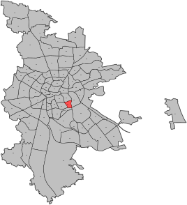
Location of the statistical district 12
|
|
|
Corner of Guntherstrasse Rankestrasse northeast
|
|
Guntherstraße is the name of the statistical district 12 in Nuremberg's southern city , which forms part of the wider southern inner city belt . Colloquially be Guntherstraße and Glockenhof because of their street names that the Nibelungensage stem, also called Nibelungenviertel.
geography
The Guntherstrasse district is bordered by Wodanstrasse in the north, Münchener Strasse in the east, Frankenstrasse in the south and Allersberger Strasse in the west.
The north-eastern part of the district is on the 3424 Gleißhammer district and the southwest on the 3423 Gibitzenhof district .
| Neighboring statistical districts | |||||||||
|---|---|---|---|---|---|---|---|---|---|
|
history
In 1906, for the Bavarian State Exhibition, the area between the train station and Dutzendteich began to be used. Until the 1920s, the areas in the Guntherstrasse area were built on with villas, in contrast to the rest of the southern part of the city, which was used for industrial areas and workers' apartments.
The TeKaDe plant was built in the south-western part of the district, at the corner of Allersberger Strasse and Frankenstrasse, where the Nürbanum is located today .
See also
Web links
- District data sheet Nuremberg - Statistical District 12 Guntherstrasse , as of 2015 (PDF; 105 kB)
Individual evidence
- ^ City of Nuremberg, Office for Urban Research and Statistics for Nuremberg and Fürth (ed.): Statistical Yearbook of the City of Nuremberg 2016 . December 2015, ISSN 0944-1514 , 18 Statistical City Districts and Districts, p. 244–245 , p. 244 ( nuernberg.de [PDF; 6.3 MB ; accessed on November 1, 2017]).
- ^ City map service Nuremberg. Retrieved November 7, 2014 .
- ^ Hermann Jansen: General development plan for Nuremberg. 1923, Retrieved October 7, 2014 .
- ↑ Industrial buildings. www.bauzeugen.de, accessed on November 7, 2014 .


