Hasenbuck
|
Hasenbuck
Statistical District 40 Statistical District 400 City of Nuremberg
Coordinates: 49 ° 25 ′ 34 ″ N , 11 ° 5 ′ 19 ″ E
|
|
|---|---|
| Height : | 322–343 m above sea level NN |
| Area : | 56.3 km² |
| Residents : | 4129 (Dec. 31, 2015) |
| Population density : | 73 inhabitants / km² |
| Incorporation : | July 18, 1910 |
| Incorporated into: | Nuremberg |
| Postal code : | 90461 |
| Area code : | 0911 |
|
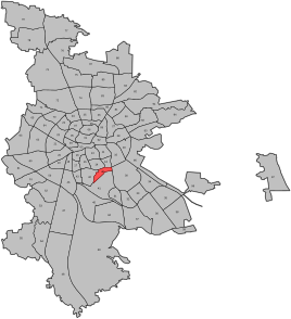
Location of the statistical district 40 Hasenbuck in Nuremberg
|
|
The Hasenbuck is an elevation in the south of Nuremberg . It is located in statistical district 40, which belongs to statistical district 4 southern outer city .
For easier identification, the statistical district 40 is also referred to internally as "Hasenbuck" by the Nuremberg Office for Urban Research and Statistics; however, this designation was not determined by a city council resolution.
Geographical location
The Hasenbuck is located between the marshalling yard , Katzwanger Strasse , Frankenstrasse and Tiroler Strasse . Its height is 342.7 m. Geologically, it is an island mountain made of castle sandstone , surrounded by Keupersand .
| Neighboring statistical districts | |||||||||
|---|---|---|---|---|---|---|---|---|---|
|
Neighboring districts
Neighboring statistical districts are Hummelstein and Guntherstrasse in the north, Dutzendteich in the east, the marshalling yard in the east-southeast and Katzwanger Strasse in the west.
history
The first documentary mention of the Hasenbuck goes back to the years 1721 and 1731. Allegedly there was a dispute over hunting rights during this time. At the beginning of the 19th century, the Hasenbuck was made accessible to hunting tenants and embellished with a stone pyramid and some installations and made a lookout point. In 1841 the construction of the iron foundry and machine factory Klett & Comp , today the MAN engine factory in Nuremberg, 1903 the marshalling yard , from 1927 residential buildings of the building cooperative of war victims and survivors eG, today the housing cooperative Nürnberg Süd-Ost e. G., built. The Luther Church , inaugurated on July 25, has been located on the summit of Hasenbuck since 1937 .
Infrastructure
On public transport there is the Nuremberg U-Bahn (stops U-Bahnhof Hasenbuck ; in the north-west the U-Bahnhof Frankenstraße ), the tram line 5 and the city bus lines 58, 65 and 68.
See also
Web links
- Helmut Beer: Hasenbuck . In: Michael Diefenbacher , Rudolf Endres (Hrsg.): Stadtlexikon Nürnberg . 2nd, improved edition. W. Tümmels Verlag, Nuremberg 2000, ISBN 3-921590-69-8 ( complete edition online ).
- The Hasenbuck on Nuremberg Photos
Individual evidence
- ^ City of Nuremberg, Office for Urban Research and Statistics Nuremberg (ed.): Statistical Yearbook of the City of Nuremberg 2016 . December 2015, ISSN 0944-1514 , 18 Statistical City Districts and Districts, p. 244–245 , p. 244 ( nuernberg.de [PDF; 6.3 MB ; accessed on November 1, 2017]).
- ↑ Statistical Yearbook of the City of Nuremberg 2013, page 238
- ↑ Overview map: Statistical districts in Nuremberg
- ^ A week in Nuremberg by Carl Mainberger on Google Books
- ^ Website of the housing association Nürnberg Süd-Ost e. G. ( Memento of the original from March 11, 2012 in the Internet Archive ) Info: The archive link was inserted automatically and has not yet been checked. Please check the original and archive link according to the instructions and then remove this notice.


