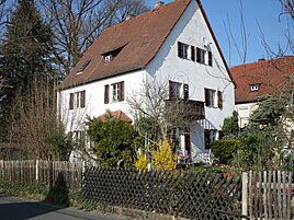
Outdoor settlement
|
Free Range
Statistical District 944 City of Nuremberg
Coordinates: 49 ° 28 '10 " N , 11 ° 10' 49" E
|
|
|---|---|
| Height : | 300-310 m above sea level NN |
| Residents : | 620 (Dec 31, 1997) |
| Incorporation : | July 1, 1972 |
| Postal code : | 90482 |
| Area code : | 0911 |
|
Location of the statistical district 94 Laufamholz in Nuremberg
|
|
|
Property in open ground
|
|
The open-air settlement is located in the east of the Nuremberg district of Laufamholz and, as open-air, is part of the statistical district 94.
history
The open-air settlement was incorporated into Nuremberg on July 1, 1972. Before the regional reform it belonged to the municipality of Schwaig .
geography
The statistical district 944 Freiland borders in the west roughly on a line parallel to Henfenfelder Strasse on Laufamholzer district 942 Ottensooser Strasse, Hammer . In the north, beyond the Pegnitz, is the Erlenstegen District 913 waterworks . The federal motorway 3 forms the border to Schwaig b in the east. Nürnberg ( district of Nürnberger Land ) and the railway line Nürnberg – Schwandorf in the south the border to the community-free area Laufamholzer Forst , which belongs to the Lorenzer Reichswald .
| Statistical Neighboring Districts of District 944 Free Range | |||||||||
|---|---|---|---|---|---|---|---|---|---|
|
In the eastern part of the area, the Schneidersbach flows through it from south to north, where it flows into the Pegnitz. The Hülzlgraben , which is largely piped, flows further west .
Infrastructure
The settlement is on the arterial road to the east, which in this area is called Laufamholzstrasse. In the south it is affected by the S-Bahn line S1. On December 31, 1997 it had 620 inhabitants.
Architectural monuments
On Laufamholzstrasse is one of seven boundary stones that used to mark the city limits of Nuremberg. The stone with the inscription Nürnberg and the city arms in colored stone mosaic was erected in 1951.
Landscape protection area Pegnitztal-Ost
The undeveloped areas in the east of the area are in the Pegnitztal Ost landscape protection area ( LSG-00536.05 ).
Street names
After the incorporation there was the situation of double street names, such as Schillerstrasse. That is why, with the exception of Laufamholzstrasse and Freilandstrasse, the streets in this area were named after Nordic writers: Andersenstrasse , Ibsenstrasse , Lagerlöfstrasse and Strindbergstrasse .
See also
- Incorporation into the city of Nuremberg
- List of architectural monuments in Nuremberg's eastern outer city
Web links
- Outdoors . In: Michael Diefenbacher , Rudolf Endres (Hrsg.): Stadtlexikon Nürnberg . 2nd, improved edition. W. Tümmels Verlag, Nuremberg 2000, ISBN 3-921590-69-8 ( complete edition online ).
Individual evidence
- ^ City of Nuremberg, Office for Urban Research and Statistics for Nuremberg and Fürth (ed.): Statistical Yearbook of the City of Nuremberg 2016 . December 2015, ISSN 0944-1514 , 18 Statistical City Districts and Districts, p. 19-20 , p. 20 ( nuernberg.de [PDF; 6.3 MB ; accessed on November 1, 2017]).
- ^ City map service Nuremberg District 944 Freiland
- ↑ World Database on Protected Areas - LSG Pegnitztal Ost (English)


