
Buchenbühl
|
Buchenbühl
Statistical District 86 City of Nuremberg
Coordinates: 49 ° 30 ′ 15 " N , 11 ° 6 ′ 36" E
|
|
|---|---|
| Height : | 338 (324-347) m |
| Area : | 3.14 km² |
| Residents : | 2262 (Dec. 31, 2015) |
| Population density : | 721 inhabitants / km² |
| Incorporation : | July 22, 1922 |
| Postal code : | 90411 |
| Area code : | 0911 |
 Location of the statistical district 86
|
|
 Ensemble Paulusstein
|
|
Buchenbühl has been a part of Nuremberg since July 22, 1922 ( Statistical District 86 - Buchenbühl ) and is located northeast of the city center. The district is almost entirely from Sebalder Reichswald surrounded and is in the north of the A 3 and the power Forst , south of brick and in the southwest of the airport Nuremberg limited.
location
| Neighboring statistical districts | |||||||||
|---|---|---|---|---|---|---|---|---|---|
|
.svg)
history
The settlement was opened from 1919 immediately after the First World War on the unauthorized initiative of the “ Soldiers' Council at III. Army Corps ”on the westernmost spur of the Haidberg, below the“ Buchenbühl ”. Jakob Schmeissner and Ludwig Ruff worked as architects . In order to employ the dismissed soldiers and armaments workers who had become unemployed, the Reichswald south of the Graefenberg Railway was cleared without a permit and without funding . The original settlement center is the Paulusstein, a memorial stone on the local road from Nuremberg to Kalchreuth and Heroldsberg . On May 2, 1919 the "Siedlungswerk Nürnberg" was founded as a corporation under public law in order to secure funding. The settlers jointly built the first two-story semi-detached houses on plots of up to 2000 m² in size. The enormous size of the property should give the settlers the possibility of self-sufficiency. That's why every property had a small barn annex. The semi-detached houses varied by two basic types, on the eaves side facing the street with a mansard roof and on the gable side with high pitched roofs. The rights to use the property were raffled among the settlers after completion. In the 1930s, more single-storey houses were added. The development with single-storey houses lasted until the 1960s. New construction activity declined drastically in the 1970s for reasons of noise protection due to the proximity to the Nuremberg airport. Buchenbühl reaches up to 800 m from the airport runway. Some houses are less than 300 m away from the approach lane.
Finds near today's Buchenbühl point to late Neolithic settlements, which cannot be classified in more detail in terms of time. In 1834 Germany's first dinosaur skeleton, a Plateosaurus , was excavated on the slopes of the “Buchenbühl” .
Education and churches

Buchenbühl has a primary school on Kalchreuther Straße (the secondary school was dissolved at the end of the 2013/14 school year). There is also an education center of the Bavarian State Forests AöR on Rathsbergstrasse.
In 1938, a prayer hall for the Evangelical Lutheran parish was built on Vollandstrasse. Since 1954 the parish has been an independent parish in the dean's office in Nuremberg. The Church of the Assumption, inaugurated in 1961, offers a sleek frame with effective lighting for three impressive wooden sculptures by the Buchenbühl-based woodcarver Otto Fuchs. There is also the Catholic parish Maria-Hilf, an independent church foundation founded in 1963. The Maria-Hilf-Kirche is a branch church of the parish of St. Georg Ziegelstein. In Buchenbühl there is a Protestant kindergarten (so-called forest kindergarten) and a Catholic day-care center in the former prayer room , which looks after children from the first year of life until they start school.
Infrastructure
Economy and urban transport
North of the A 3, in the curved track of the Graefenbergbahn, is the Hahnenbalz industrial area, which emerged from a sawmill.
Buchenbühl has had a bus connection to Ziegelstein since 1928 and is now connected to the Nuremberg subway via bus line 21 .
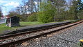
Nürnberg-Buchenbühl stop
.jpg)
Through this district leading Gräfenbergbahn which formerly a breakpoint Nuremberg Buchenbühl ⊙ had both sides of the junction with the Märzenweg.
It was opened on January 13, 1926 by the Royal Bavarian State Railways as a replacement for the former Ziegelstein station , which was located further south, and closed by the Deutsche Bundesbahn on May 31, 1983, together with the thinning of the Graefenberg Railway timetable. The platforms, which are separated according to the direction of travel, have been preserved to this day.
Since the end of the 1990s, after the renovation of the Graefenbergbahn, the city of Nuremberg and the VGN have been calling for the stop to be reopened. However, this is rejected by the Bavarian Railway Company and the Bavarian Ministry of Economic Affairs .
- photos

The southern platform (2008)
The northern platform (2008)

northern platform in winter


Hiking trails
The Franconian Marienweg runs through Buchenbühl .
Culture
In 1923 a men's singing group was founded in Buchenbühl, which in 1931 joined the general sports club Buchenbühl and which was dissolved in 1933. In 1954 the Nuremberg-Buchenbühl men's choir was founded.
The Volkstrachtenverein Buchenbühl was founded in 1938 by members of a Plattler group of the Buchenbühler Siedlergemeinschaft and from other traditional costume associations and cultivates Franconian customs.
The Evangelical Trombone Choir Buchenbühl has existed since 1952, takes part in the Ascension Day of the Evangelical Church of the Assumption every year, plays on the Sunday in mid-July for the traditional morning pint at the Catholic Maria-Hilf Church and holds a forest service on the airport meadow on the first Sunday in July.
See also
literature
- Gerhard Pfeiffer (Ed.): Nuremberg - History of a European City . 1st edition, Munich 1971, ISBN 3-406-03394-6 .
- Commemorative publication 50 years of Buchenbühl settlers' association, construction sections I and II 1935 - 1985 .
- BBG information sheet from April 2006.
- Rudolf Groh, Knud Willenberg: Buchenbühl . Verlag Korn und Berg, Nuremberg 1991
Web links
Individual evidence
- ^ City of Nuremberg, Office for Urban Research and Statistics for Nuremberg and Fürth (ed.): Statistical Yearbook of the City of Nuremberg 2016 . December 2015, ISSN 0944-1514 , 18 Statistical City Districts and Districts, p. 244–245 , p. 245 ( nuernberg.de [PDF; 6.3 MB ; accessed on November 1, 2017]).
- ^ City of Nuremberg, Office for Urban Research and Statistics for Nuremberg and Fürth (ed.): Statistical Yearbook of the City of Nuremberg 2016 . December 2015, ISSN 0944-1514 , 18 Statistical City Districts and Districts, p. 19-20 , p. 19 ( nuernberg.de [PDF; 6.3 MB ; accessed on November 1, 2017]).
- ↑ Archive link ( Memento of the original dated May 6, 2006 in the Internet Archive ) Info: The archive link was inserted automatically and has not yet been checked. Please check the original and archive link according to the instructions and then remove this notice. Chair for Applied Geology at FAU Erlangen-Nürnberg
- ↑ City of Nuremberg / Committee for Transport: Buchenbühl stop ( page no longer available , search in web archives ) Info: The link was automatically marked as defective. Please check the link according to the instructions and then remove this notice. . Report of September 27, 2007.
.svg)
.svg)
Almoshof | Altenfurt | Bärenschanze | Pearwood | White lead | Boxing Village | Brunn | Book | Buchenbühl | Doos | Dutzendteich | Eberhardshof | Eibach | Eibacher Forest | Erlenstegen | Falkenheim | Fischbach | Open air settlement | Gaismannshof | Galgenhof | Gardens near Wöhrd | Gardens behind the fortress | Garden city | Gaulnhofen | Gebersdorf | Gerasmühle | Gibitzenhof | Gleißbühl | Gleißhammer | Glockenhof | Gostenhof | Greuth | Großgründlach | Großreuth near Schweinau | Großreuth behind the fortress | Gugelstrasse | Guntherstrasse | Hammer | Hasenbuck | Herpersdorf | Herrnhütte | Himpfelshof | Holzheim | Courtyards | Courtly | Hummelstein | St. Jobst | St. Johannis | Katzwang | Kettelersiedlung | Kleingründlach | Kleinreuth near Schweinau | Kleinreuth behind the fortress | Kleinweidenmühle | Klingenhof | Royal court | Koppenhof | Kornburg | Powerhouse | Settlement of war sacrifices | Krottenbach | Long water | Laufamholz | St. Leonhard | Leyh | Lichtenhof | Tan | Loher Moos | Lohhof | Lorenz | Ludwigsfeld | Maiach | Marienberg | Marienvorstadt | Maxfeld | Middle mill | Mögeldorf | Moorenbrunn | Mooshof | Muggenhof | Mühlhof | Net stall | Neukatzwang | Neulandsiedlung | Neunhof | Neuröthenbach | Neuselsbrunn | North Station | Northeast Station | Oberbürg | Obermühle | St. Peter | Pillenreuth | Pirckheimerstrasse | Rabus | Marshalling yard settlement | Rechenberg | Rehhof | Reichelsdorf | Reichelsdorfer Keller | Rennweg | Reutles | Rosenau | Röthenbach near Schweinau | Sandberg | Sandreuth | Sheep farm | Schmalau | Schnepfenreuth | Schniegling | Schoppershof | Schweinau | Sebald | Seeleinsbühl | Spitalhof | Quarries | Steinbühl | Stone slab | Sündersbühl | Tafelhof | Clay | Tullnau | Lower guarantee | Veilhof | Vistula Garden | Weigelshof | Weiherhaus | Werderau | Westfriedhof | Wetzendorf | Wöhrd | Worzeldorf | Zerzabelshof | Brick | Customs House
(0) Old town and closer inner city : (01) Old town, St. Lorenz | (02) Marienvorstadt | (03) Tafelhof | (04) Gostenhof | (05) Himpfelshof | (06) Old Town, St. Sebald | (07) St. Johannis | (08) Pirckheimerstraße | (09) Wöhrd • (1) Further inner city belt south : (10) Ludwigsfeld | (11) Glockenhof | (12) Guntherstrasse | (13) Galgenhof | (14) Hummelstein | (15) Gugelstrasse | (16) Steinbühl | (17) Gibitzenhof | (18) Sandreuth | (19) Schweinau • (2) Further inner city belt west / north / east : (20) St. Leonhard | (21) Sündersbühl | (22) Bärenschanze | (23) Sandberg | (24) Bielingplatz | (25) Uhlandstrasse | (26) Maxfeld | (27) Veilhof | (28) Tullnau | (29) Gleißhammer • (3) Southeastern outer city : (30) Dutzendteich | (31) Marshalling yard settlement | (32) Langwasser Northwest | (33) Langwasser Northeast | (34) Beuthener Strasse | (35) Altenfurt North | (36) Langwasser Southeast | (37) Langwasser Southwest | (38) Altenfurt, Moorenbrunn | (39) Nuremberg-Feucht business park • (4) Southern outer city : (40) Hasenbuck | (41) Marshalling yard | (42) Katzwanger Strasse | (43) Dianastraße | (44) Trier Street | (45) Garden City | (46) Werderau | (47) Maiach | (48) Katzwang, Reichelsdorf Ost, Reichelsdorfer Keller | (49) Kornburg, Worzeldorf • (5) South-western outskirts : (50) Hohe Marter | (51) Röthenbach West | (52) Röthenbach Ost | (53) Eibach | (54) Reichelsdorf | (55) Krottenbach, Mühlhof • (6) Western outer city : (60) Großreuth near Schweinau | (61) Gebersdorf | (62) Gaismannshof | (63) Courts | (64) Eberhardshof | (65) Muggenhof • (7) Northwest outer city : (70) Westfriedhof | (71) Schniegling | (72) Wetzendorf | (73) book | (74) clay | (75) Almoshof | (76) Kraftshof | (77) Neunhof | (78) Boxdorf | (79) Großgründlach • (8) Northeastern outer city : (80) Schleifweg | (81) Schoppershof | (82) Sheep Farm | (83) Marienberg | (84) brick | (85) Mooshof | (86) Buchenbühl | (87) Airport • (9) East outer city : (90) St. Jobst | (91) Erlenstegen | (92) Mögeldorf | (93) Schmausenbuckstrasse | (94) Laufamholz | (95) Zerzabelshof | (96) Fischbach | (97) Well