Rechenberg (Nuremberg)
|
Rechenberg
Statistical District 902 City of Nuremberg
Coordinates: 49 ° 27 ′ 48 ″ N , 11 ° 6 ′ 36 ″ E
|
|
|---|---|
| Height : | 338 m above sea level NHN |
| Postal code : | 90491 |
| Area code : | 0911 |
|
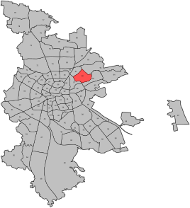
Location of the statistical district 90 St. Jobst in Nuremberg
|
|
|
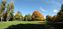
The Rechenberg in Nuremberg
|
|
The Rechenberg is a small park in Nuremberg . Rechenberg is also the name for the approximately 338 m high elevation in the northeast of the city of Nuremberg and the name of the district 902 in the statistical district 9 - Eastern outer city in the statistical district 90 ( St. Jobst ).
location
The Rechenberg is located in the northeast of Nuremberg in the St. Jobst district, north of the Äußere Sulzbacher Straße. It extends in an east-west direction and has a size of 5.6 hectares. Its center is formed by the eponymous "Rechenberg", a ridge made of castle sandstone (approx. 338 m above sea level ).
history
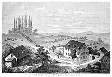
Between 1524 and 1527, Sebald Rech had his first manor built on the hill as a residential tower with a moat. 1545–1551 the seat belonged to Adolarius Vischer († 1551), from 1551 to his creditors. During the Second Margrave War , the City Council of Nuremberg had the seat burned down in 1552. Later troops of Margrave Albrecht Alcibiades occupied the mountain and shot at Nuremberg from here. In 1553 the Nuremberg council had part of the hilltop removed. A second mansion was built in 1553, belonged to Sebastian Zatzer from 1577, Joachim Kammermeister (Camerarius) from 1589, the Nutzel von Sündersbühl from 1624 , the Ebner von Eschenbach from 1728 , the Kreß von Kressenstein from 1754 , and the Behaim von Schwarzbach from around 1790 on Kirchensittenbach ( Ludwig Feuerbach lived there from 1859 until his death in 1872 ), 1898–1916 the house belonged to the Tucher von Simmelsdorf and the Barth family; In 1916 the seat was demolished.
Towards the end of the 18th century there was an estate in Rechenberg (1 courtyard with inhabited outbuildings). The high court exercised the imperial city of Nuremberg , but this was disputed by the Brandenburg-Bayreuth Oberamt Baiersdorf . The landlord was the Nuremberg owner von Behaim .
As part of the municipal edict, Rechenberg was assigned to the Erlenstegen tax district formed in 1813 . It also belonged to the rural community of Erlenstegen , which was founded in the same year . With the second community edict (1818), Rechenberg was re-incorporated into the newly formed Rennweg rural community . When Rennweg was incorporated into the city of Nuremberg in 1865, the rural community was called Schoppershof . In 1899 this was incorporated into Nuremberg .
In 1860 the philosopher Ludwig Feuerbach moved to the Rechenberg, where a village had developed in the meantime at the gates of the city of Nuremberg, and lived in the aforementioned second manor in the nearby Sulzbacher Strasse until his death on September 13, 1872. In 1930 a cenotaph was donated to him . After the National Socialists came to power, this memorial was removed by decision of the city council in 1933 and was not erected again until 1955.
In the south (Schleiermacherstraße) of the hill, early cooperative row houses were built in 1915, and in the north (Lützowstraße and Nettelbeckstraße) Art Deco buildings were built at the end of the 1920s . In 1930, the Regiomontanus observatory was built as a public observatory with funds from the Nuremberg Physical Society .
Population development
| year | 1818 | 1824 | 1840 | 1861 | 1871 | 1885 |
|---|---|---|---|---|---|---|
| Residents | 17th | 14th | 11 | 17th | 20th | 15th |
| Houses | 4th | 3 | 3 | 3 | ||
| source |
religion
The place has been predominantly Protestant since the Reformation. Originally the inhabitants of the Evangelical Lutheran denomination went to St. Sebald , later to St. Jobst .
Todays use
The Rechenberg Park is a long strip of parkland east and west of the Rechenberg. In winter it is used as a toboggan hill. The observatory offers lectures and guided tours on clear days. There is also a playground on the hilltop, two round, single basketball courts and an asphalt football field .
literature
- Hanns Hubert Hofmann : Nuremberg-Fürth (= Historical Atlas of Bavaria, part Franconia I, 4). Commission for Bavarian State History, Munich 1954, DNB 452071224 , p. 162 ( digitized version ). Ibid. S. 242-243 ( digitized version ).
- Hermann Rusam: Rechenberg . In: Michael Diefenbacher , Rudolf Endres (Hrsg.): Stadtlexikon Nürnberg . 2nd, improved edition. W. Tümmels Verlag, Nuremberg 2000, ISBN 3-921590-69-8 , p. 861-862 ( online ).
Web links
- Rechenberg in the historical directory of the association for computer genealogy
Individual evidence
- ↑ Rechenberg in the Bavaria Atlas
- ↑ Hermann Rusam, p. 861f.
- ↑ Herrensitze.com (Giersch / Schlunk / von Haller)
- ↑ HH Hofmann, p. 162.
- ↑ a b H. H. Hofmann, p. 242f.
- ↑ Feuerbach in Nuremberg
- ↑ nuernberg-aha.de: Sankt Jobst - with Steinplatte, Rechenberg u. Free thinking
- ↑ Only inhabited houses are given. In 1818 and 1824 these were designated as fireplaces , in 1840 as houses , from 1871 to 1885 as residential buildings.
- ↑ Alphabetical index of all the localities contained in the Rezatkkreis according to its constitution by the newest organization: with indication of a. the tax districts, b. Judicial Districts, c. Rent offices in which they are located, then several other statistical notes . Ansbach 1818, p. 74 ( digitized version ).
- ↑ Eduard Vetter (Ed.): Statistical handbook and address book of Middle Franconia in the Kingdom of Bavaria . Self-published, Ansbach 1846, p. 212 ( digitized version ).
- ^ Joseph Heyberger, Chr. Schmitt, v. Wachter: Topographical-statistical manual of the Kingdom of Bavaria with an alphabetical local dictionary . In: K. Bayer. Statistical Bureau (Ed.): Bavaria. Regional and folklore of the Kingdom of Bavaria . tape 5 . Literary and artistic establishment of the JG Cotta'schen Buchhandlung, Munich 1867, Sp. 1066 , urn : nbn: de: bvb: 12-bsb10374496-4 ( digitized ).
- ↑ Kgl. Statistical Bureau (ed.): Complete list of localities of the Kingdom of Bavaria. According to districts, administrative districts, court districts and municipalities, including parish, school and post office affiliation ... with an alphabetical general register containing the population according to the results of the census of December 1, 1875 . Adolf Ackermann, Munich 1877, 2nd section (population figures from 1871, cattle figures from 1873), Sp. 1231 , urn : nbn: de: bvb: 12-bsb00052489-4 ( digital copy ).
- ↑ K. Bayer. Statistical Bureau (Ed.): Localities directory of the Kingdom of Bavaria. According to government districts, administrative districts, ... then with an alphabetical register of locations, including the property and the responsible administrative district for each location. LIV. Issue of the contributions to the statistics of the Kingdom of Bavaria. Munich 1888, Section III, Sp. 1165 ( digitized version ).
- ^ Regiomontanus Observatory Nuremberg


