Sebald (Nuremberg)
|
Old town, St. Sebald
Statistical District 06 City of Nuremberg
Coordinates: 49 ° 27 ′ 18 ″ N , 11 ° 4 ′ 46 ″ E
|
|
|---|---|
| Height : | 306 m |
| Area : | 79.6 ha |
| Residents : | 9275 (Dec. 31, 2015) |
| Population density : | 11,652 inhabitants / km² |
| Postal code : | 90403 |
| Area code : | 0911 |
|
Location of the statistical district 06 Altstadt, St. Sebald
|
|
|
Old town St. Sebald
|
|
Sebald , also called Sebalder Altstadt or Old Town, St. Sebald , is the northern part of the old town of Nuremberg and the name is district 3450 .
geography
Sebald is bounded in the west, north and east by the Nuremberg city wall and the Nuremberg castle along the Neutorgraben, the Vestnertorgraben, the Maxtorgraben and the Laufertorgraben. In the south the Pegnitz forms the border with Lorenz . The flea market and parts of the island of Schütt belong to the district 3450 Nürnberg-Sebald but not to the statistical district 06 Altstadt, St. Sebald .
| Neighboring statistical districts | |||||||||
|---|---|---|---|---|---|---|---|---|---|
|
structure
The quarter is criss-crossed by many office and commercial buildings. It was badly damaged by the air raids of World War II , so that in the first years after the war it was even referred to as the Sebald Steppe. While large parts of the east of the main market in particular were built in the simple post-war architecture of the 1950s and 1960s, there are many historical buildings and streets, some of which have been reconstructed, in the remaining quarter.
People have been driving tunnels and cellars in the Nuremberg rocks since the 14th century . There are therefore numerous former rock cellars , which were used as air raid shelters during the Second World War, under the district . The best known of these bunkers is the panier bunker .
See also
history
Sebald was named after Saint Sebaldus of Nuremberg , who might have built a St. Peter's Chapel north of the Pegnitz River himself. As part of the old town, the history of the quarter is otherwise largely identical to the history of the city of Nuremberg .
Attractions

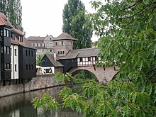
More than half of the sights of Nuremberg summarized under the Nuremberg Historic Mile are located in the old town of Sebald. The best known include:
- Imperial Castle
- Church of St. Sebald
- St. Egidien Church
- Tucherschlößchen
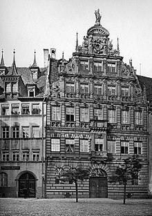
- Pellerhaus
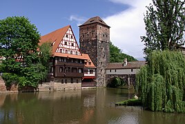
- Weinstadel
- Albrecht Dürer's House
- Fembo house
- Main market with a beautiful fountain
- Weißgerbergasse (Nuremberg)
- Rock passages (Nuremberg)
- Hole prisons (Nuremberg)
The world-famous Nuremberg Christkindlesmarkt also takes place every year during Advent on the main market.
Public facilities
- Nuremberg town hall
- Nuremberg City Library
- Registration office
- Public order office
- Integration office
- Treasury and tax office
- Health department
Museums
- Albrecht Dürer's House
- Amber Museum Nuremberg
- Deutsches Museum Nürnberg (under construction)
- German Games Archive Nuremberg
- Executioner's House Nuremberg
- Rock passages
- Historical art bunker
- Hat Museum Nuremberg
- Imperial Castle Museum
- Medieval dungeons
- Museum Tucherschloss with Hirsvogel Hall
- Toy Museum Nuremberg
- City Museum Fembohaus
education
traffic
-
 : Documentation Center
  - St. Peter
  - Dürrenhof - Rathenauplatz - Town Hall - Main Market - Plärrer


-
 : Heilig-Geist-Spital
  - City Hall - Maxfeld
  - Vocational Promotion Agency - War victims' settlement
 -
 : Heilig-Geist-Spital
  - Rathaus - Maxfeld
  - Nordostbahnhof - Martha-Maria-Krhs.
-
 : Heilig-Geist-Spital
  - Rathaus - Maxfeld
  - Thon
  - Forchheimer Str.
In addition, the Franconian Marienweg runs through Sebald .
literature
- Wiltrud Fischer-Pache: Sebald city side . In: Michael Diefenbacher , Rudolf Endres (Hrsg.): Stadtlexikon Nürnberg . 2nd, improved edition. W. Tümmels Verlag, Nuremberg 2000, ISBN 3-921590-69-8 ( complete edition online ).
Web links
- District data sheet Nuremberg - Statistical District 06 Old Town, St. Sebald , as of 2015 (PDF; 120 kB)
Individual evidence
- ^ City of Nuremberg, Office for Urban Research and Statistics for Nuremberg and Fürth (ed.): Statistical Yearbook of the City of Nuremberg 2016 . December 2015, ISSN 0944-1514 , 18 Statistical City Districts and Districts, p. 244–245 , p. 244 ( nuernberg.de [PDF; 6.3 MB ; accessed on November 1, 2017]).
- ^ City map service Nuremberg , accessed March 15, 2012
- ↑ Guided tours in the bread bunker


