
Laufertorkeller

The Laufertorkeller or Laufertorbunker is a former underground bunker in the northeastern part of the Sebald old town in Nuremberg in Bavaria .
description
The name of the approximately 2000 square meter facility is the Nürnberger Laufer Tor . The abandoned bunker is part of an approximately 25,000 square meter cellar system in the northern old town. The facility is located west of the Laufer Tor tower, extends north to the Maxtormauer and west to almost the economic and social sciences faculty (WiSo) of the Friedrich-Alexander-Universität .
To the west, the Laufertorbunker is connected to the Tucherkeller and Panierskeller via the Tucherstollen .
Since the 14th century, people have been driving tunnels and rock cellars in the sandstone keuper of Nuremberg's castle hill . The tunnels were used to obtain water for the city and the rock cellars as storage facilities for the local breweries. Originally the cellar system, which is up to 16 meters deep, consisted of independent cellars. Nuremberg lacked house cellars to protect the population. That is why the beer cellars were expanded from 1940 and connected with each other by tunnels from 1943. During the Second World War , the cellars were converted into bunkers by forced laborers . They served tens of thousands of people as an air raid shelter until American troops marched into Nuremberg in April 1945 . Many Nuremberg residents survived the destruction of their city here on the evening of January 2, 1945. In some areas of the cellars, there were also protected areas for the city administration.
The bunker system itself extends over three levels, but not one above the other. The entire cellar is spacious and connected underground with the Staufferkeller (Unterer Laufertorkeller) to the east , the Middle Laufertorkeller and the Uhlkeller to the west . The original cellars, which were only carved in sandstone, were partly lined with bricks or clad with concrete during the expansion . Necessary infrastructure such as emergency power generators , toilet facilities , ventilation systems and supply facilities were also installed. During the expansion in 1943, another entrance was created at Äusseren Laufer Platz. Building material was scarce and the lining was made with bricks that were originally intended for the construction of the Nuremberg Congress Hall. The construction work there had been largely stopped in 1940.
Middle Laufertor cellar
This part of the facility was primarily used to manage the so-called “works and railways” and as a shelter for around 250 other people. From here, the municipal works coordinated the deployment of maintenance teams for damaged gas and water pipes, the repair of destroyed tram tracks and the power grid. This part of the facility is relatively comfortable. The walls are almost completely clad with concrete and the floors are tiled. Individual sections used as offices had wooden doors. In addition to toilet facilities, the infrastructure for an emergency power supply and ventilation for the entire bunker was also located here. Part of the section could also be used as a shelter by the population.
Upper Laufertor cellar
The former Uhlkeller served entirely as a public air raid shelter. During the expansion, it was connected to the Mittleren Laufertor cellar via a downward staircase. Originally, this part of the bunker had two separate entrances, which today have been walled up or filled in. In the 1970s, most of the basement was lined with shotcrete to stabilize it (torpedoed). This part of the facility also contained part of the water supply and water storage.
Lower Laufertor cellar
The deepest, high, cathedral-like rooms, probably initially served as an ice cellar . After the renovation, there was space here for filter rooms and an alternative quarter for the military district . In addition, an emergency kitchen with several 3000 liter boilers was built in. Plans to expand and use the kitchen after the end of the war were rejected due to hygienic inadequacies. An emergency well was built in the northern part of the cellar . The 40 meter deep well was kept operational after the end of the war as part of the disaster control and was only given up in the 2010s and is now in decline. The cellar is connected to the Tucherstollen here. The Tucherstollen initially served to drain the Tucherkeller and was then used as an escape tunnel down to Wöhrder Wiese during World War II.
Todays use
The facility is no longer used today. Today the widely ramified system is only accessible as part of special tours. As part of the commemoration of the destruction of Nuremberg, guided tours were offered in January 2012, 2016 and 2020 by the Friends of the Nürnberger Felsengänge eV .
With the exception of two entrances and the Tucherstollen, all of the original entrances have now been walled up or filled in. Access to a private house in the southern part of the facility was permanently blocked. Parts of the facility were filled with rubble or are used to deposit dismantled material. Sintering, stalactites and colorful mineral washouts that are well worth seeing have now formed as a result of penetrating water.
The remains of the former ventilation shafts and chimneys are also visible above ground. In the area of the former Laufertorzwinger there are still five chimneys.
Picture gallery

Access tunnel lined with bricks

Area of "plants and railways"

Scrap storage of the ventilation pipes
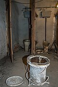
Men's toilet and mobile toilet
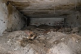
Room filled with rubble

Upper Laufertorkeller (Uhlkeller)

Water storage in the Uhlkeller

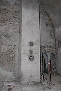
Stairs connecting the middle and lower Laufertorkeller
Abandoned deep well
Former emergency kitchen with fireplace

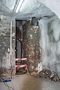
Access tunnel to the Tucherstollen

Chimneys of the bunker system


Individual evidence
- ↑ Location of the facility in the BayernAtlas , accessed on December 30, 2019
- ↑ Geology of the Nuremberg Castle Hill , accessed on December 30, 2019
- ↑ Plan and pictures of the Laufertorkeller accessed on December 30, 2019
- ↑ bauzeugen.wordpress.com, pictures and information accessed on December 30, 2019
- ↑ www.nordbayern.de, Large crowd during the Laufertorbunker tours , accessed on December 30, 2019
- ↑ www.nordbayern.de, Off to Nuremberg's Underworld: Special tours to rock cellars , accessed on December 30, 2019
literature
- Walter Herppich: The underground Nuremberg. Nuremberg 2001, ISBN 3-87191-301-4 .
- Förderverein Nürnberger Felsengänge eV, NUREMBERG UNDERGROUND, From "secret passages and rock vaults", Verlag Nürnberger Presse
Web links
Coordinates: 49 ° 27 '27 " N , 11 ° 5' 15.2" E