Eberhardshof
|
Eberhardshof
Statistical District 64 City of Nuremberg
Coordinates: 49 ° 27 '28 " N , 11 ° 1' 40" E
|
|
|---|---|
| Height : | 298–305 m above sea level NHN |
| Area : | 1.23 km² |
| Residents : | 9418 (December 31, 2015) |
| Population density : | 7,636 inhabitants / km² |
| Postcodes : | 90431, 90429 |
| Area code : | 0911 |
|
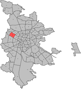
Location of the statistical district 64 Eberhardshof in Nuremberg
|
|
|
Gasthaus Eberhardshof 1
|
|
Eberhardshof is a district and the statistical district 64 in the western outskirts of Nuremberg as part of the Höfen district.
location
The statistical district extends from Maximilianstrasse in the east to the Ringbahn in the west and from the Pegnitz in the north to the Frankenschnellweg in the south and consists of the districts of Eberhardshof and Seeleinsbühl.
| Neighboring statistical districts | |||||||||
|---|---|---|---|---|---|---|---|---|---|
|
history
The place was first mentioned in a document in 1344. At that time the place was owned by the Elisabeth Hospital of the German Order Coming Nuremberg .
Towards the end of the 18th century there were 2 properties in Eberhardshof. The high court was disputed between the Brandenburg-Ansbach Oberamt Cadolzburg and the imperial city of Nuremberg . The landlord was the German Order Coming Nuremberg .
As part of the community edict , Eberhardshof was assigned to the Höfen tax district formed in 1808 . It also belonged to the rural community of Höfen , which was founded in the same year .
The Ludwigseisenbahn (1835) and the Ludwig-Danube-Main Canal (1840) were built through the area of today's Eberhardshof.
On January 1, 1899, Eberhardshof became part of the city of Nuremberg.
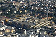
Along the railway, Fürther Straße in the Eberhardshof area developed into an industrial focus in Nuremberg. Toy manufacturers settled here first. The Nuremberg motorcycle industry peaked in the 1950s, followed by its decline at the end of the decade. In the area of the Eberhardshof subway station, Quelle set up a department store and delivery center, as well as AEG and Triumph-Adler production facilities . With the closure of the production of TA and then of AEG, another structural change began in the 1990s. Opened in 2009, Arcandor a bankruptcy procedure and closed source.
Architectural monuments
- Eberhardshof 1: guest house
- Eberhardshof 2: residential building
- Various tenement houses
- Former Quelle mail order company
Population development
| year | 1818 | 1840 | 1861 | 1871 | 1885 | 1900 |
|---|---|---|---|---|---|---|
| Residents | 8th | 21st | 16 | 30th | 34 | 30th |
| Houses | 2 | 2 | 4th | 4th | ||
| source |
Local transport
Eberhardshof between underground station Maximilian Street and Metro Station Muggenhof and has between them nor the Metro Station Eberhardshof . Because of the U1, the former Nuremberg-Fürth tram line was discontinued in 1981 . The Nuremberg-Neusündersbühl station had to give way to the four-track expansion of the Nuremberg-Fürth railway line in 2008.
literature
- Johann Kaspar Bundschuh : Eberhardtshof . In: Geographical Statistical-Topographical Lexicon of Franconia . tape 1 : A-egg . Verlag der Stettinische Buchhandlung, Ulm 1799, DNB 790364298 , OCLC 833753073 , Sp. 668 ( digitized version ).
- Günther P. Fehring , Anton Ress , Wilhelm Schwemmer: The city of Nuremberg (= Bavarian art monuments . Volume 10 ). 2nd Edition. Deutscher Kunstverlag, Munich 1977, ISBN 3-422-00550-1 , p. 275-276 .
- Wiltrud Fischer-Pache: Eberhardshof . In: Michael Diefenbacher , Rudolf Endres (Hrsg.): Stadtlexikon Nürnberg . 2nd, improved edition. W. Tümmels Verlag, Nuremberg 2000, ISBN 3-921590-69-8 , p. 230 ( online ).
- Hanns Hubert Hofmann : Nuremberg-Fürth (= Historical Atlas of Bavaria, part Franconia I, 4). Commission for Bavarian State History, Munich 1954, DNB 452071224 , p. 110 ( digitized version ). Ibid. S. 240 ( digitized version ).
- Werner Sprung: The Eberhardshof and the Muggenhof. Two former hamlets at the gates of the imperial city. In: Communications from the Association for the History of the City of Nuremberg: Eberhardshof and Muggenhof , No. 50, Association for the History of the City of Nuremberg , 1960, p. 53 ff. ( Online )
Web links
- Eberhardshof in the historical directory of the association for computer genealogy
Individual evidence
- ^ City of Nuremberg, Office for Urban Research and Statistics for Nuremberg and Fürth (ed.): Statistical Yearbook of the City of Nuremberg 2016 . December 2015, ISSN 0944-1514 , 18 Statistical City Districts and Districts, p. 244–245 , p. 245 ( nuernberg.de [PDF; 6.3 MB ; accessed on November 1, 2017]).
- ↑ Statistical city districts and districts ( Memento of the original from April 8, 2011 in the Internet Archive ) Info: The archive link was inserted automatically and has not yet been checked. Please check the original and archive link according to the instructions and then remove this notice. (PDF; 1.0 MB) at statistik.nuernberg.de
- ↑ Eberhardshof in the Bavaria Atlas
- ^ City map service of the city of Nuremberg , accessed January 24, 2010
- ^ W. Fischer-Pache, p. 230.
- ↑ HH Hofmann, p. 110.
- ↑ HH Hofmann, p. 240.
- ↑ Statistical Yearbook 2009 of the City of Nuremberg ( Memento of the original from March 4, 2016 in the Internet Archive ) Info: The archive link was inserted automatically and has not yet been checked. Please check the original and archive link according to the instructions and then remove this notice. (PDF; 7.3 MB)
- ↑ Only inhabited houses are given. In 1818 these are known as fireplaces , in 1840 as houses , and from 1871 to 1900 as residential buildings.
- ↑ Alphabetical index of all the localities contained in the Rezatkkreis according to its constitution by the newest organization: with indication of a. the tax districts, b. Judicial Districts, c. Rent offices in which they are located, then several other statistical notes . Ansbach 1818, p. 20 ( digitized version ).
- ↑ Eduard Vetter (Ed.): Statistical handbook and address book of Middle Franconia in the Kingdom of Bavaria . Self-published, Ansbach 1846, p. 207 ( digitized version ).
- ^ Joseph Heyberger, Chr. Schmitt, v. Wachter: Topographical-statistical manual of the Kingdom of Bavaria with an alphabetical local dictionary . In: K. Bayer. Statistical Bureau (Ed.): Bavaria. Regional and folklore of the Kingdom of Bavaria . tape 5 . Literary and artistic establishment of the JG Cotta'schen Buchhandlung, Munich 1867, Sp. 1065 , urn : nbn: de: bvb: 12-bsb10374496-4 ( digitized ).
- ↑ Kgl. Statistical Bureau (ed.): Complete list of localities of the Kingdom of Bavaria. According to districts, administrative districts, court districts and municipalities, including parish, school and post office affiliation ... with an alphabetical general register containing the population according to the results of the census of December 1, 1875 . Adolf Ackermann, Munich 1877, 2nd section (population figures from 1871, cattle figures from 1873), Sp. 1230 , urn : nbn: de: bvb: 12-bsb00052489-4 ( digital copy ).
- ↑ K. Bayer. Statistical Bureau (Ed.): Localities directory of the Kingdom of Bavaria. According to government districts, administrative districts, ... then with an alphabetical register of locations, including the property and the responsible administrative district for each location. LIV. Issue of the contributions to the statistics of the Kingdom of Bavaria. Munich 1888, Section III, Sp. 1165 ( digitized version ).
- ↑ K. Bayer. Statistical Bureau (Ed.): Directory of localities of the Kingdom of Bavaria, with alphabetical register of places . LXV. Issue of the contributions to the statistics of the Kingdom of Bavaria. Munich 1904, Section II, Sp. 1145 ( digitized version ).


