Schafhof (Nuremberg)
|
Schafhof
Statistical District 82 City of Nuremberg
Coordinates: 49 ° 28 ′ 48 ″ N , 11 ° 7 ′ 6 ″ E
|
|
|---|---|
| Height : | 322–343 m above sea level NN |
| Area : | 2.75 km² |
| Residents : | 2231 (December 31, 2015) |
| Population density : | 812 inhabitants / km² |
| Area code : | 0911 |
|
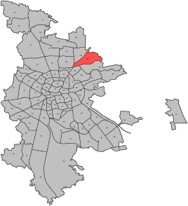
Location of the statistical district 82 Schafhof
|
|
|
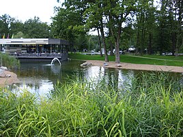
Northeast Park Nuremberg
|
|
Schafhof is a district of Nuremberg . It forms the statistical district 82.
location
Schafhof is in the northeast of Nuremberg, southeast of Äußere Bayreuther Str. Neighboring districts are Ziegelstein in the north, Erlenstegen in the southeast, Spitalhof in the south, Klingenhof and Herrnhütte in the southwest and Loher Moos in the west. In the northeast is the extensive Nordostpark technology park .
| Neighboring statistical districts | |||||||||
|---|---|---|---|---|---|---|---|---|---|
|
history
Schafhof was later occasionally called Katzenlohe. The place was first mentioned in 1361 as "Schefhof". In 1427 the wasteland was sold to Nuremberg. In both Margrave Wars and in the Thirty Years War , Schafhof fell victim to the flames. In 1796 the place fell to Prussia and in 1810 to Bavaria. Schafhof became part of Erlenstegen. The incorporation to Nuremberg took place in 1899 together with the localities of St. Jobst , Spitalhof and Thumenberg ( Platnersberg ) in the overall context of the incorporation of Erlenstegens. In 1824 13 residents lived in the two half courtyards. In 1911/12 the district agricultural school was relocated from Lichtenhof to Schafhof. From 1913 to 1974 there was an educational institution for school-leavers here. In 1964 the old farms were torn down. After the Second World War there were two refugee camps and a homeless settlement in Schafhof. A home for asylum seekers still exists.
Infrastructure
The Äußere Bayreuther Straße runs northwest of Schafhof and leads out of town as Bundesstraße 2 to Bundesautobahn 3 . The south-west of Schafhof is connected to Nuremberg's public transport with the Herrnhütte underground station and the northeast train station. An eye clinic, a fast food restaurant, a large car dealership as well as many companies and factories have settled in Schafhof after the Second World War.
Churches
The Evangelical Lutheran Gnadenkirche Schafhof, a half-timbered building designed by Otto Bartning at Neumeyerstraße 47, was built in 1951 and is a listed building. The church is a community center (also referred to as "Notkirche Type D") , a successor to the emergency churches that were built in Germany between 1949 and 1953 as part of an aid program by the aid organization of the Evangelical Churches in Germany .
literature
- Helmut Beer: Erlenstegen . In: Michael Diefenbacher , Rudolf Endres (Hrsg.): Stadtlexikon Nürnberg . 2nd, improved edition. W. Tümmels Verlag, Nuremberg 2000, ISBN 3-921590-69-8 ( complete edition online ).
Web links
Individual evidence
- ^ City of Nuremberg, Office for Urban Research and Statistics for Nuremberg and Fürth (ed.): Statistical Yearbook of the City of Nuremberg 2016 . December 2015, ISSN 0944-1514 , 18 Statistical City Districts and Districts, p. 244–245 , p. 245 ( nuernberg.de [PDF; 6.3 MB ; accessed on November 1, 2017]).


