
Großgründlach
|
Großgründlach
Statistical District 79 Statistical District 790 City of Nuremberg
|
|
|---|---|
 |
|
| Height : | 302 m above sea level NHN |
| Area : | 5.09 km² |
| Residents : | 4675 (December 31, 2015) |
| Population density : | 919 inhabitants / km² |
| Incorporation : | July 1, 1972 |
| Postal code : | 90427 |
| Area code : | 0911 |
 Location of the statistical district 79 Großgründlach in Nuremberg
|
|
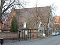
 View over Großgründlacher Hauptstrasse to the church from the south
|
|
Großgründlach (colloquially: "Gro u sgrindla") is a district of Nuremberg and lies on the border with the urban areas of Fürth and Erlangen . It belongs to the statistical district 7 Northwestern outer city and together with Reutles and Kleingründlach forms the statistical district 79.
location
| Neighboring statistical districts | |||||||||
|---|---|---|---|---|---|---|---|---|---|
|
.svg)
geography
The district is located north of the city center near the approach path to Nuremberg Airport and forms a closed settlement with Reutles to the northeast and Schmalau to the south . The Gründlach and Mühlbach, a tributary of the Gründlach, flow through the village . In the northwest the corridor area borders Stöckelwiesen, in the north Bei der Marter and in the east Himmelreich. In the west lies the forest area Maze and the alluvial and mill ponds. The Obermühle and Kleingründlach are located there . The Knoblauchsland begins in the south .
The 352 hectare landscape of the Gründlach with its side ditches between the A73 motorway in the west, the city limits in the north, east and southwest and Würzburger Straße and Neunhof in the south is designated as a landscape protection area Gründlachtal-Ost.
history

.jpg)
The place was first mentioned in a document issued by Emperor Heinrich II in Augsburg in 1021 as "Crintilaha", when the king transferred this place, together with other places, to the Bamberg Church "for the salvation of his soul" . It is therefore the oldest mentioned district of Nuremberg, the document even 29 years older than the first mention of Nuremberg itself (1050). The place name is derived from the same name of the river Gründlach , the meaning of which is unclear.
At the end of the 18th century there were 70 properties in Großgründlach. The high court exercised the imperial city of Nuremberg , but this was disputed by the Brandenburg-Bayreuth Oberamt Baiersdorf . The Nuremberg owner von Haller ruled the village and community . The landlords were the Oberamt Baiersdorf (1 forge, 1 house, 1 community bathhouse), the parish of Bruck (4 estates) and the Nuremberg owner von Haller (2 yards, 6 half yards, 3 estates, 36 estates, 7 houses, 3 taverns, 1 forge) , 3 bakers, manor, rectory, schoolhouse, parish guard house).
As part of the municipal edict, the Großgründlach tax district was formed in 1811 , to which Reutles and Obermühle also belonged. In the same year the rural community Großgründlach was formed, which was congruent with the tax district. It was subordinate to the Erlangen Regional Court in administration and jurisdiction and to the Erlangen Rent Office for financial administration . In voluntary jurisdiction, 30 properties were subordinate to the Patrimonial Court (PG) Großgründlach from 1821 to 1848 , 1 property from 1821 to 1835 to the PG Groß- und Kleingeschaidt and 3 properties from 1823 to 1835 to the PG Nemsdorf . From 1862 Großgründlach was administered by the Fürth district office (renamed the Fürth district in 1938 ). In 1862 jurisdiction was transferred to the Fürth District Court , and since 1880 it has been with the Fürth District Court . The financial management was taken over in 1871 by the Rentamt Fürth (renamed Finanzamt Fürth in 1920 ). In 1912 Kleingründlach and Mittelmühle were reassigned from Eltersdorf to Großgründlach. In 1961 the municipality had an area of 4.283 km².
The place was spun off from the district of Fürth on July 1, 1972 as part of the municipal reform and incorporated into Nuremberg .
Population development
Großgründlach community (= Großgründlach district)
| year | 1818 | 1840 | 1852 | 1861 | 1867 | 1871 | 1875 | 1880 | 1885 | 1890 | 1895 | 1900 | 1905 | 1910 | 1919 | 1925 | 1933 | 1939 | 1946 | 1950 | 1961 | 1970 | 1987 | 2009 | 2015 |
|---|---|---|---|---|---|---|---|---|---|---|---|---|---|---|---|---|---|---|---|---|---|---|---|---|---|
| Residents | 551 | 643 | 666 | 638 | 658 | 677 | 692 | 776 | 760 | 643 | 665 | 670 | 705 | 725 | 776 | 818 | 941 | 988 | 1223 | 1395 | 1768 | 2900 | 4098 | 4880 | 4675 |
| Houses | 100 | 115 | 111 | 123 | 125 | 152 | 191 | 302 | 1074 | ||||||||||||||||
| source |
Place Großgründlach
| year | 1818 | 1840 | 1861 | 1871 | 1885 | 1900 | 1925 | 1950 | 1961 | 1970 |
|---|---|---|---|---|---|---|---|---|---|---|
| Residents | 443 * | 499 * | 513 | 547 * | 610 * | 553 | 622 | 1125 | 1367 | 2497 |
| Houses | 80 * | 94 * | 99 * | 103 | 116 | 149 | 233 | |||
| source |
religion
The place has been predominantly Protestant since the Reformation. The residents of the Evangelical Lutheran denomination are parish to St. Laurentius (Großgründlach) , the residents of the Roman Catholic denomination are parish to St. Hedwig (Großgründlach) .
Attractions
Townscape
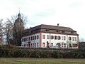
In addition to other historic half-timbered and stone houses, the Goldener Schwan inn on Hauptstrasse is particularly impressive: a gable-independent building with a mighty gable roof, the stone gable of which dates from 1776. The walled churchyard, which serves as a cemetery, with a well-fortified church building (see the fortified church in the neighboring Kraftshof ) and the adjoining Baroque castle to the west, which is surrounded by a stone wall, are further formative structures.
church
The square tower of the Church of St. Lorenz (St. Laurentius), which can be verified as early as 1303 and has been used by Cistercian women since 1348 (see also Himmelthron Monastery ), was built in the east above the choir (choir tower ); the three lower floors are exposed to stone (with a sundial each on the east and south side), the octagonal bell floor is plastered.
Inside there are pieces of equipment from different times: grave slab, stained glass, baroque grave monument, gallery with organ, door fittings.
Golden Swan Inn by SSO
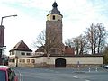
Churchyard and town hall of O
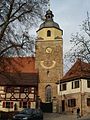
Church with west tower and town hall from S
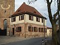
Town hall, sundial on the church tower


To the east on the outskirts of Reutles is the St. Felicitas Chapel, which is also worth seeing and was probably built in 1370. The tower of the chapel, painted entirely in reddish-brown, was not built until 500 years later.
Lordship, monastery and castle
.jpg)
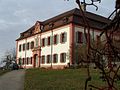
In the place of today's baroque palace was probably the ancestral castle built in the 13th century for the Reich ministerial family von Gründlach . Gründlach became the center of their extended rule. Their possessions were concentrated in the area of the Sebalder Reichswald , on both sides of the Regnitz and Erlanger Schwabach , in the Seebachgrund as well as on the Bibert and Zenn . Around 1314/15 the Gründlacher family died out and the sole heiress was Margarete von Gründlach. She and her husband, Count Gottfried von Hohenlohe-Brauneck were in 1323 forced most of the possessions, including personal property Gründlach to Burggraf Friedrich IV. For sale of Nuremberg to pledge and 1326th
In 1343 the burgraves Johann and Albrecht sold the "Veste" to Kunigunde von Orlamünde , widow of Count Otto VII. Von Orlamünde , who founded the Cistercian monastery Himmelthron that year . The castle and its accessories (including the surrounding tree garden and the building yard above the main street) valued at 5,000 pounds sterling initially served as fixed assets of the monastery, which was managed by Countess Konrad Groß , the founder of the Nuremberg Heilig-Geist-Spital, entrusted. However, there were disputes that led to the move of the convent to Großgründlach in 1348. The parish church was converted into a monastery church and for this purpose extended with a nuns choir up to the castle, which in turn was adapted to the monastery. In the course of the Reformation , the convent itself dissolved in 1525. The imperial city set up its own office for the 36 properties in Großgründlach and an estate in Reutles , the caretaker of which lived in the monastery castle, where Wolf Löffelholz held office until his death in 1545 . In the Second Margrave War Gründlach was burned down on May 23, 1552.
In 1572, the Nuremberg patrician Philipp Geuder bought the buildings with the associated property, which the council had only sparsely repaired after 1552, for 12,000 guilders, and had the castle rebuilt within the existing enclosing walls at considerable expense. After his untimely death in 1581 the property fell to his widow Katharina, née. Welser , who had provided the capital required for the purchase. The castle was only provisionally restored and was still designed as a defense structure. Illustrations before 1634 and pen drawings by Johann Andreas Graff from 1685 show a square with a side length of almost 30 meters. The old keep rose on the south-east corner, in front of which a gatehouse was built, next to it the entrance led into the largely windowless ground floor and the inner courtyard. Turrets on the top floor corresponded to the keep at the other three corners; a roof bay rose also in the middle of the southern front. The former nuns' church, which was also two-story under one roof with the nave of the church, was built on the east side.
In 1616 the Pfinzing inherited the castle and manor, which led to decades of litigation with the Welser family, who also laid claim to Gründlach. In 1634 the castle, village and church were destroyed by troops from the curbs. The castle remained in ruins for 50 years. Karl Sebastian Pfinzing did not begin with the reconstruction until 1685. The plans were made by Johann Trost, who died in 1700. At the end of 1698 the building was largely completed. Using the preserved outer walls, a baroque two-storey four-wing building was built in place of the old castle, which surrounds a regular courtyard (the open arcades on the south side were only walled up in 1924). The keep was demolished as well as the former monastery church, which had formed the link between the castle and the parish church. This was probably built in the 13th century instead of a castle chapel, the apse foundations of which were discovered in 1987 in the nave of the church; the rising brickwork on the north side is still preserved in the north nave wall of today's church. The south side of the lock consists of nine axles, wherein the middle gate axis a projections and a dormer in the gambrel has. The interior work dragged on for a long time. The richly stuccoed theater hall is decorated with the alliance coat of arms of Christoph Carl Pfinzing (1680–1739) and his wife Helena Catharina Tucher , who died in 1720 . The Latin inscription above the entrance reports the completion of the construction work for the year 1723. In the following decades, several rooms received splendid stucco ceilings.
After the Gründlach line of the Pfinzing family came to an end, the castle and the manor came to the Henfenfeld line in 1739 and, after its extinction in 1764/66, to the Haller von Hallerstein , hence the name Hallerschloss . These also continued the beautification of the palace and garden. Above all, in 1769 an avenue was laid out to create a line of sight from the entrance gate on the main road through the baroque garden in front of the castle to the west, which led to a chain of ponds between the two arms of the Gründlach, which had gradually been abandoned since 1794. The avenue of pyramid poplars that was newly planted around this time had to be replaced several times later, most recently in autumn 2004 by winter linden trees. The castle has belonged to the twin brothers Johann Georg and Johann Sigmund Haller von Hallerstein since 1766. For the latter, who from 1794 to 1804, as Reichsschultheiß, directed the fortunes of Nuremberg until shortly before its incorporation by the Kingdom of Bavaria, a classicist monument was erected in 1805 on an artificial hill in the so-called Herrenwiese.
The castle has belonged to Sigmund Frhr since 1873 . von Haller's Family Foundation . A bomb attack in 1943 caused considerable damage to the roof, windows, doors and stucco ceilings, which were repaired again from 1947. Parts of the baroque gardens and parks have been preserved; to the west an avenue leads into the landscape.

Castle from SW
Castle, view from SO
Castle, view from NW
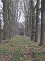
Avenue west of the castle of W (laid down in 2004 and replanted with winter linden trees)


traffic
The district road N 1 / FÜs 4 runs west to Herboldshof (1.6 km west) or past Boxdorf to federal road 4 (1.6 km east). Communal roads run to Kleingründlach (1 km northwest), Tennenlohe (1.8 km northeast), Reutles (0.8 km northeast) and Schmalau (1.2 km south).
There is a direct connection to public transport with buses to Nuremberg (lines 290 and 31, formerly lines 28 and 29), Fürth (line 179) and Erlangen (line 290). There is a regular bus connection with Erlangen by changing to lines 20 and 30 at the Reutleser Straße stop. Großgründlach is well connected to the motorway network. The A 3 can be reached within 5 minutes via the Erlangen Tennenlohe junction and the A 73 can be reached within a few minutes via the Erlangen Eltersdorf and Fürth Steinach junction.
On the Nuremberg – Bamberg railway line there was the Großgründlach stop in Kleingründlach. It was hit by trains until June 2, 1991. After the abandonment of the stop, which was previously rarely used in regular traffic, the connection between Großgründlach and Vach train station was maintained a few years later with regular taxis. This has now also been discontinued.
literature
- Johann Kaspar Bundschuh : Gründlach . In: Geographical Statistical-Topographical Lexicon of Franconia . tape 2 : El-H . Verlag der Stettinische Buchhandlung, Ulm 1800, DNB 790364298 , OCLC 833753081 , Sp. 418-419 ( digitized version ).
- Dehio : Bayern I: Franken , 2nd edition, Munich 1999, p. 404f.
- Günther P. Fehring , Anton Ress , Wilhelm Schwemmer: The city of Nuremberg (= Bavarian art monuments . Volume 10 ). 2nd Edition. Deutscher Kunstverlag, Munich 1977, ISBN 3-422-00550-1 , p. 344-352 .
- August Gebeßler : City and District of Fürth (= Bavarian Art Monuments . Volume 18 ). Deutscher Kunstverlag, Munich 1963, DNB 451450957 , p. 95-102 .
- Mr. Bertold Haller von Hallerstein: Großgründlach . In: Michael Diefenbacher , Rudolf Endres (Hrsg.): Stadtlexikon Nürnberg . 2nd, improved edition. W. Tümmels Verlag, Nuremberg 2000, ISBN 3-921590-69-8 , p. 381 ( online ).
- Hanns Hubert Hofmann : Nuremberg-Fürth (= Historical Atlas of Bavaria, part Franconia I, 4). Commission for Bavarian State History, Munich 1954, DNB 452071224 , p. 119-120 ( digitized version ). Ibid. S. 228 ( digitized version ).
- Wolfgang Wiessner: City and District of Fürth (= Historical Place Name Book of Bavaria, Middle Franconia . Volume 1 ). Commission for Bavarian State History, Munich 1963, DNB 455524629 , p. 43-47 .
Web links
- Full story
- Großgründlach in the location database of the Bavarian State Library Online . Bavarian State Library
- Großgründlach in the Topographia Franconiae of the University of Würzburg , accessed on September 26, 2019.
- Großgründlach in the historical directory of the association for computer genealogy
Individual evidence
- ↑ a b City of Nuremberg, Office for Urban Research and Statistics for Nuremberg and Fürth (ed.): Statistical Yearbook of the City of Nuremberg 2016 . December 2015, ISSN 0944-1514 , 18 Statistical City Districts and Districts, p. 244–245 , p. 245 ( nuernberg.de [PDF; 6.3 MB ; accessed on November 1, 2017]).
- ↑ a b W. Wiessner, p. 43ff.
- ↑ a b Großgründlach in the Bavaria Atlas
- ↑ Green list of landscape protection areas in Middle Franconia. Bavarian State Office for the Environment (LfU), July 15, 2016, accessed on August 17, 2017 .
- ↑ HH Hofmann, p. 119f.
- ↑ HH Hofmann, p. 228; Address and statistical handbook for the Rezatkreis in the Kingdom of Baiern . Buchdruckerei Chancellery, Ansbach 1820, p. 31 ( digitized version ).
- ↑ a b c Bavarian State Statistical Office (ed.): Official city directory for Bavaria, territorial status on October 1, 1964 with statistical information from the 1961 census . Issue 260 of the articles on Bavaria's statistics. Munich 1964, DNB 453660959 , Section II, Sp. 779-780 ( digitized version ).
- ^ Wilhelm Volkert (ed.): Handbook of Bavarian offices, communities and courts 1799–1980 . CH Beck, Munich 1983, ISBN 3-406-09669-7 , p. 602 .
- ^ City of Nuremberg, Office for Urban Research and Statistics for Nuremberg and Fürth (ed.): Statistical Yearbook of the City of Nuremberg 2016 . December 2015, ISSN 0944-1514 , 18 Statistical City Districts and Districts, p. 19-20 , p. 19 ( nuernberg.de [PDF; 6.3 MB ; accessed on November 1, 2017]).
- ↑ a b Only inhabited houses are given. In 1818 these were designated as fireplaces , in 1840 as houses , and from 1871 to 1987 as residential buildings.
- ↑ a b Alphabetical index of all the localities contained in the Rezatkreise according to its constitution by the newest organization: with indication of a. the tax districts, b. Judicial Districts, c. Rent offices in which they are located, then several other statistical notes . Ansbach 1818, p. 32 ( digitized version ). For the community of Großgründlach plus the residents and buildings of Obermühle (p. 67) and Reutles (p. 75).
- ^ A b Eduard Vetter (Ed.): Statistical handbook and address book of Middle Franconia in the Kingdom of Bavaria . Self-published, Ansbach 1846, p. 89-90 ( digitized version ).
- ↑ a b c d e f g h i j k l Bavarian State Statistical Office (Hrsg.): Historical municipality directory: The population of the municipalities of Bavaria from 1840 to 1952 (= contributions to Statistics Bavaria . Issue 192). Munich 1954, DNB 451478568 , p. 172 , urn : nbn: de: bvb: 12-bsb00066439-3 ( digitized version ).
- ↑ a b Joseph Heyberger, Chr. Schmitt, v. Wachter: Topographical-statistical manual of the Kingdom of Bavaria with an alphabetical local dictionary . In: K. Bayer. Statistical Bureau (Ed.): Bavaria. Regional and folklore of the Kingdom of Bavaria . tape 5 . Literary and artistic establishment of the JG Cotta'schen Buchhandlung, Munich 1867, Sp. 1028 , urn : nbn: de: bvb: 12-bsb10374496-4 ( digitized version ).
- ↑ a b Kgl. Statistical Bureau (ed.): Complete list of localities of the Kingdom of Bavaria. According to districts, administrative districts, court districts and municipalities, including parish, school and post office affiliation ... with an alphabetical general register containing the population according to the results of the census of December 1, 1875 . Adolf Ackermann, Munich 1877, 2nd section (population figures from 1871, cattle figures from 1873), Sp. 1191 , urn : nbn: de: bvb: 12-bsb00052489-4 ( digital copy ).
- ↑ a b K. Bayer. Statistical Bureau (Ed.): Localities directory of the Kingdom of Bavaria. According to government districts, administrative districts, ... then with an alphabetical register of locations, including the property and the responsible administrative district for each location. LIV. Issue of the contributions to the statistics of the Kingdom of Bavaria. Munich 1888, Section III, Sp. 1123 ( digitized version ).
- ↑ a b K. Bayer. Statistical Bureau (Ed.): Directory of localities of the Kingdom of Bavaria, with alphabetical register of places . LXV. Issue of the contributions to the statistics of the Kingdom of Bavaria. Munich 1904, Section II, Sp. 1191-1192 ( digitized version ).
- ↑ a b Bavarian State Statistical Office (ed.): Localities directory for the Free State of Bavaria according to the census of June 16, 1925 and the territorial status of January 1, 1928 . Issue 109 of the articles on Bavaria's statistics. Munich 1928, Section II, Sp. 1228-1229 ( digitized version ).
- ↑ a b Bavarian State Statistical Office (ed.): Official place directory for Bavaria - edited on the basis of the census of September 13, 1950 . Issue 169 of the articles on Bavaria's statistics. Munich 1952, DNB 453660975 , Section II, Sp. 1061 ( digitized version ).
- ↑ a b Bavarian State Statistical Office (Hrsg.): Official local directory for Bavaria . Issue 335 of the articles on Bavaria's statistics. Munich 1973, DNB 740801384 , p. 167 ( digitized version ).
- ↑ Bavarian State Office for Statistics and Data Processing (Ed.): Official local directory for Bavaria, territorial status: May 25, 1987 . Issue 450 of the articles on Bavaria's statistics. Munich November 1991, DNB 94240937X , p. 323 ( digitized version ).
- ↑ St. Laurentius Church , Alexander Racz, Kunstnürnberg: The story of St. Lorenz in Großgründlach, Nuremberg, 2014.
- ↑ St. Felicitas Chapel
- ^ History based on: Giersch / Schlunk / von Haller: Castles and mansions in the Nuremberg countryside
.svg)
.svg)
Almoshof | Altenfurt | Bärenschanze | Pearwood | White lead | Boxing Village | Brunn | Book | Buchenbühl | Doos | Dutzendteich | Eberhardshof | Eibach | Eibacher Forest | Erlenstegen | Falkenheim | Fischbach | Open air settlement | Gaismannshof | Galgenhof | Gardens near Wöhrd | Gardens behind the fortress | Garden city | Gaulnhofen | Gebersdorf | Gerasmühle | Gibitzenhof | Gleißbühl | Gleißhammer | Glockenhof | Gostenhof | Greuth | Großgründlach | Großreuth near Schweinau | Großreuth behind the fortress | Gugelstrasse | Guntherstrasse | Hammer | Hasenbuck | Herpersdorf | Herrnhütte | Himpfelshof | Holzheim | Courtyards | Courtly | Hummelstein | St. Jobst | St. Johannis | Katzwang | Kettelersiedlung | Kleingründlach | Kleinreuth near Schweinau | Kleinreuth behind the fortress | Kleinweidenmühle | Klingenhof | Royal court | Koppenhof | Kornburg | Powerhouse | Settlement of war sacrifices | Krottenbach | Long water | Laufamholz | St. Leonhard | Leyh | Lichtenhof | Tan | Loher Moos | Lohhof | Lorenz | Ludwigsfeld | Maiach | Marienberg | Marienvorstadt | Maxfeld | Middle mill | Mögeldorf | Moorenbrunn | Mooshof | Muggenhof | Mühlhof | Net stall | Neukatzwang | Neulandsiedlung | Neunhof | Neuröthenbach | Neuselsbrunn | North Station | Northeast Station | Oberbürg | Obermühle | St. Peter | Pillenreuth | Pirckheimerstrasse | Rabus | Marshalling yard settlement | Rechenberg | Rehhof | Reichelsdorf | Reichelsdorfer Keller | Rennweg | Reutles | Rosenau | Röthenbach near Schweinau | Sandberg | Sandreuth | Sheep farm | Schmalau | Schnepfenreuth | Schniegling | Schoppershof | Schweinau | Sebald | Seeleinsbühl | Spitalhof | Quarries | Steinbühl | Stone slab | Sündersbühl | Tafelhof | Clay | Tullnau | Lower guarantee | Veilhof | Vistula Garden | Weigelshof | Weiherhaus | Werderau | Westfriedhof | Wetzendorf | Wöhrd | Worzeldorf | Zerzabelshof | Brick | Customs House
(0) Old town and closer inner city : (01) Old town, St. Lorenz | (02) Marienvorstadt | (03) Tafelhof | (04) Gostenhof | (05) Himpfelshof | (06) Old Town, St. Sebald | (07) St. Johannis | (08) Pirckheimerstraße | (09) Wöhrd • (1) Further inner city belt south : (10) Ludwigsfeld | (11) Glockenhof | (12) Guntherstrasse | (13) Galgenhof | (14) Hummelstein | (15) Gugelstrasse | (16) Steinbühl | (17) Gibitzenhof | (18) Sandreuth | (19) Schweinau • (2) Further inner city belt west / north / east : (20) St. Leonhard | (21) Sündersbühl | (22) Bärenschanze | (23) Sandberg | (24) Bielingplatz | (25) Uhlandstrasse | (26) Maxfeld | (27) Veilhof | (28) Tullnau | (29) Gleißhammer • (3) Southeastern outer city : (30) Dutzendteich | (31) Marshalling yard settlement | (32) Langwasser Northwest | (33) Langwasser Northeast | (34) Beuthener Strasse | (35) Altenfurt North | (36) Langwasser Southeast | (37) Langwasser Southwest | (38) Altenfurt, Moorenbrunn | (39) Nuremberg-Feucht business park • (4) Southern outer city : (40) Hasenbuck | (41) Marshalling yard | (42) Katzwanger Strasse | (43) Dianastraße | (44) Trier Street | (45) Garden City | (46) Werderau | (47) Maiach | (48) Katzwang, Reichelsdorf Ost, Reichelsdorfer Keller | (49) Kornburg, Worzeldorf • (5) South-western outskirts : (50) Hohe Marter | (51) Röthenbach West | (52) Röthenbach Ost | (53) Eibach | (54) Reichelsdorf | (55) Krottenbach, Mühlhof • (6) Western outer city : (60) Großreuth near Schweinau | (61) Gebersdorf | (62) Gaismannshof | (63) Courts | (64) Eberhardshof | (65) Muggenhof • (7) Northwest outer city : (70) Westfriedhof | (71) Schniegling | (72) Wetzendorf | (73) book | (74) clay | (75) Almoshof | (76) Kraftshof | (77) Neunhof | (78) Boxdorf | (79) Großgründlach • (8) Northeastern outer city : (80) Schleifweg | (81) Schoppershof | (82) Sheep Farm | (83) Marienberg | (84) brick | (85) Mooshof | (86) Buchenbühl | (87) Airport • (9) East outer city : (90) St. Jobst | (91) Erlenstegen | (92) Mögeldorf | (93) Schmausenbuckstrasse | (94) Laufamholz | (95) Zerzabelshof | (96) Fischbach | (97) Well