
Großreuth near Schweinau
|
Großreuth near Schweinau
Statistical District 60 City of Nuremberg
Coordinates: 49 ° 26 ′ 0 ″ N , 11 ° 1 ′ 30 ″ E
|
|
|---|---|
| Height : | 329–339 m above sea level NHN |
| Area : | 4.95 km² |
| Residents : | 6038 (Dec. 31, 2015) |
| Population density : | 1,220 inhabitants / km² |
| Incorporation : | January 1, 1899 |
| Postcodes : | 90439, 90431 |
| Area code : | 0911 |
 Location of the district 3427 Großreuth near Schweinau in Nuremberg
|
|
 Inn in Großreuth
|
|
Großreuth bei Schweinau is a district in the southwest of Nuremberg and a statistical district of Nuremberg, which belongs to the statistical district 6 “Western outer city” . Around 5000 people live in Großreuth. There are three kindergartens and a school in the district, one of which is part of the Dunant primary school. The Protestant St. Thomas Church is located in the heart of Großreuth near Schweinau.
location
The Großreuth district borders on Kleinreuth bei Schweinau to the west, Gebersdorf to the southwest and Sündersbühl to the east . Gaismannshof is to the north and Schweinau to the southeast .
| Neighboring statistical districts | |||||||||
|---|---|---|---|---|---|---|---|---|---|
|
.svg)
history
In 1303 the Nuremberg burgrave Konrad II († 1314) transferred the place as an anniversary foundation with eleven other places, including Großreuth, the cathedral chapter of Bamberg. In both Margrave Wars (1449–1450 and 1552–1555) the place was burned down, in 1632 it was in the middle of the theater of the Thirty Years' War .
Towards the end of the 18th century there were 26 properties in Großreuth near Schweinau (3 courtyards, 10 half courtyards, 8 small farms, 4 houses, 1 shepherd's house). The high court exercised the Brandenburg-Ansbach Oberamt Schwabach , but this was contested by the imperial city of Nuremberg . The Bamberg cathedral provost office in Fürth held the village and community rulership and the land rulership over all properties .
As part of the municipal edict, the Großreuth tax district was formed in 1808 , to which Felsen bei Stein , Gebersdorf and Kleinreuth belonged. In the same year, the rural community Großreuth was formed, which was congruent with the tax district. In administration and jurisdiction it was subordinate to the Regional Court of Nuremberg and in financial administration to the Fürth Rent Office . From 1862 Großreuth was administered by the Nuremberg District Office . Jurisdiction has been with the Nuremberg District Court since 1880 . The financial management was taken over in 1871 by the Nuremberg Rent Office ( renamed the Nuremberg Tax Office in 1920 ). In 1875, the Nürnberg-Stein train station was built in the municipality . In 1885 the community had an area of 6.805 km².
The community Großreuth near Schweinau was incorporated into Nuremberg on January 1, 1899 .
South of Wallensteinstrasse, the Studio Franken of the Bavarian Broadcasting Corporation was opened in 1949 , next to it in 1995 the new building of the Bavarian State Commercial Agency. On December 31, 1997, 4331 inhabitants lived in the statistical district 60.
Population development
Großreuth community near Schweinau
| year | 1818 | 1840 | 1852 | 1855 | 1861 | 1867 | 1871 | 1875 | 1880 | 1885 | 1890 | 1895 | 1900 |
|---|---|---|---|---|---|---|---|---|---|---|---|---|---|
| Residents | 379 | 530 | 555 | 548 | 502 | 537 | 554 | 631 | 634 | 652 | 695 | 711 | 774 |
| Houses | 57 | 59 | 62 | 95 | 90 | ||||||||
| source |
Location Großreuth near Schweinau
| year | 1818 | 1840 | 1861 | 1871 | 1885 | 1900 |
|---|---|---|---|---|---|---|
| Residents | 197 | 266 | 234 | 261 | 253 | 291 |
| Houses | 29 | 28 | 50 | 32 | ||
| source |
religion
The place has been predominantly Protestant since the Reformation. The residents of the Evangelical Lutheran denomination are parish to St. Thomas (Nuremberg) , the residents of the Roman Catholic denomination are parish to To the Holy Guardian Angels (Nuremberg) .
Architectural monuments
- Evangelical Lutheran Parish Church of St. Thomas
- graveyard
- Stable houses and courtyards
- Residential houses
- Gasthaus Apollon and Gasthaus Rottner
tradition
The Großreuther Kärwa (also known as the Kirchweih in other places ), which existed before the war and has been held every year since 1979, is part of the district's tradition and is always very well attended. The Kärwa always falls on the first Sunday in July and lasts five days. Despite the fact that Großreuth has now matured into a modern, large district and is currently having to give up some of its village atmosphere through the construction of a new housing estate, the Kärwa tradition continues to be maintained according to old custom .
traffic
Two large streets lead through Großreuth, on the one hand the Wallensteinstraße, which begins in Großreuth and leads to Gebersdorf, on the other hand the Rothenburger Straße in and out of town. The supply of public transport is guaranteed by VGN lines. The underground line U3 , which previously ended between the districts of Sündersbühl and Großreuth at the Gustav-Adolf-Straße underground station , is expected to be extended to the future Großreuth underground station near Schweinau at the end of 2020 .
photos
Residential building at the confluence of Tillystrasse and Wallensteinstrasse
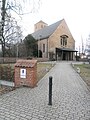
The Protestant St. Thomas Church in the rural west of the district
Commercial building, Edisonstrasse 15

Entrance to Gasthaus Rottner, Winterstrasse 15

Colorful apartment building on Tillystrasse (No. 21 to 27)
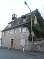
Historic sandstone block house, Alte Wallensteinstrasse 151

The St. Lioba branch church, Hornungstraße 45

High-rise residential building, Elsa-Brändström-Strasse 72

The Greek restaurant Apollon, Alte Wallensteinstrasse 149

Baptismal font in the St. Thomas Church

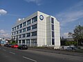
Free sculpture in front of a side entrance of the LGA complex

The Großreuth cemetery, Herbststrasse 50, with houses on Appenzeller Strasse in the background

Dependance building of the Dunant School, Wallensteinstrasse 130
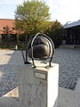
Art object in front of the main entrance of the LGA main office in Nuremberg

Tenement house, Tillystrasse 13 and 15

High-rise residential building, Elsa-Brändström-Straße 74 opposite the Hotel Novina at Tillypark

The north-west of the district is largely undeveloped and characterized by agricultural land
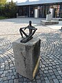
Seated flute player with the LGA main entrance in the right background

The BR shop next to the gate at the entrance to the Bayerischer Rundfunk site , Wallensteinstrasse 117

Interior view of St. Lioba, Hornungstrasse 45

The Gasthof Mouzaki, Alte Wallensteinstraße 158

The red and white painted transmission tower on the park area of the Studio Franken is 108 m high.
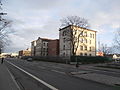
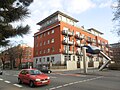
Former barracks and the Nuremberg West Police Station on the south side of Wallensteinstrasse

Building of the Hotel Rottner on Winterstrasse

The Nuremberg telecommunications tower in the Hohe Marter district towers over the transmission tower in Großreuth by 185 m.

The Tilly-Center, Wallensteinstrasse 61

Village property, Alte Wallensteinstrasse 162

The Thomaskirche in Großreuth, like the Stephanuskirche in Gebersdorf, was designed by Christian Ruck and built in 1931.


literature
- Günther P. Fehring , Anton Ress , Wilhelm Schwemmer: The city of Nuremberg (= Bavarian art monuments . Volume 10 ). 2nd Edition. Deutscher Kunstverlag, Munich 1977, ISBN 3-422-00550-1 , p. 352-353 .
- Wiltrud Fischer-Pache: Großreuth near Schweinau . In: Michael Diefenbacher , Rudolf Endres (Hrsg.): Stadtlexikon Nürnberg . 2nd, improved edition. W. Tümmels Verlag, Nuremberg 2000, ISBN 3-921590-69-8 , p. 383 ( online ).
- Hanns Hubert Hofmann : Nuremberg-Fürth (= Historical Atlas of Bavaria, part Franconia I, 4). Commission for Bavarian State History, Munich 1954, DNB 452071224 , p. 121 ( digitized version ). Ibid. S. 240 ( digitized version ).
Web links
Individual evidence
- ^ City of Nuremberg, Office for Urban Research and Statistics for Nuremberg and Fürth (ed.): Statistical Yearbook of the City of Nuremberg 2016 . December 2015, ISSN 0944-1514 , 18 Statistical City Districts and Districts, p. 244–245 , p. 245 ( nuernberg.de [PDF; 6.3 MB ; accessed on November 1, 2017]).
- ↑ Großreuth near Schweinau in the Bavaria Atlas
- ↑ a b W. Fischer-Pache, p. 383.
- ^ HH Hofmann, p. 121.
- ↑ HH Hofmann, p. 240; Address and statistical handbook for the Rezatkreis in the Kingdom of Baiern . Buchdruckerei Chancellery, Ansbach 1820, p. 62 ( digitized version ).
- ↑ a b c K. Bayer. Statistical Bureau (Ed.): Localities directory of the Kingdom of Bavaria. According to government districts, administrative districts, ... then with an alphabetical register of locations, including the property and the responsible administrative district for each location. LIV. Issue of the contributions to the statistics of the Kingdom of Bavaria. Munich 1888, Section III, Sp. 1164 ( digitized version ).
- ^ City of Nuremberg, Office for Urban Research and Statistics for Nuremberg and Fürth (ed.): Statistical Yearbook of the City of Nuremberg 2016 . December 2015, ISSN 0944-1514 , 18 Statistical City Districts and Districts, p. 19-20 , p. 19 ( nuernberg.de [PDF; 6.3 MB ; accessed on November 1, 2017]).
- ↑ a b Only inhabited houses are given. In 1818 these are known as fireplaces , in 1840 as houses , and from 1871 to 1900 as residential buildings.
- ↑ a b Alphabetical index of all the localities contained in the Rezatkreise according to its constitution by the newest organization: with indication of a. the tax districts, b. Judicial Districts, c. Rent offices in which they are located, then several other statistical notes . Ansbach 1818, p. 32 ( digitized version ). For the community of Großreuth plus the residents and buildings of Gebersdorf (p. 29) and Kleinreuth (p. 48).
- ^ A b Eduard Vetter (Ed.): Statistical handbook and address book of Middle Franconia in the Kingdom of Bavaria . Self-published, Ansbach 1846, p. 206-207 ( digitized version ).
- ↑ a b c d e f g Bavarian State Statistical Office (Hrsg.): Historical municipality register: The population of the municipalities of Bavaria in the period from 1840 to 1952 (= contributions to Statistics Bavaria . Issue 192). Munich 1954, DNB 451478568 , p. 180 , urn : nbn: de: bvb: 12-bsb00066439-3 ( digitized version ).
- ↑ a b Joseph Heyberger, Chr. Schmitt, v. Wachter: Topographical-statistical manual of the Kingdom of Bavaria with an alphabetical local dictionary . In: K. Bayer. Statistical Bureau (Ed.): Bavaria. Regional and folklore of the Kingdom of Bavaria . tape 5 . Literary and artistic establishment of the JG Cotta'schen Buchhandlung, Munich 1867, Sp. 1065 , urn : nbn: de: bvb: 12-bsb10374496-4 ( digitized ).
- ↑ a b Kgl. Statistical Bureau (ed.): Complete list of localities of the Kingdom of Bavaria. According to districts, administrative districts, court districts and municipalities, including parish, school and post office affiliation ... with an alphabetical general register containing the population according to the results of the census of December 1, 1875 . Adolf Ackermann, Munich 1877, 2nd section (population figures from 1871, cattle figures from 1873), Sp. 1230 , urn : nbn: de: bvb: 12-bsb00052489-4 ( digital copy ).
- ↑ a b K. Bayer. Statistical Bureau (Ed.): Directory of localities of the Kingdom of Bavaria, with alphabetical register of places . LXV. Issue of the contributions to the statistics of the Kingdom of Bavaria. Munich 1904, Section II, Sp. 1146 ( digitized version ). At this point in time, the community was already incorporated into Nuremberg.
.svg)
.svg)
Almoshof | Altenfurt | Bärenschanze | Pearwood | White lead | Boxing Village | Brunn | Book | Buchenbühl | Doos | Dutzendteich | Eberhardshof | Eibach | Eibacher Forest | Erlenstegen | Falkenheim | Fischbach | Open air settlement | Gaismannshof | Galgenhof | Gardens near Wöhrd | Gardens behind the fortress | Garden city | Gaulnhofen | Gebersdorf | Gerasmühle | Gibitzenhof | Gleißbühl | Gleißhammer | Glockenhof | Gostenhof | Greuth | Großgründlach | Großreuth near Schweinau | Großreuth behind the fortress | Gugelstrasse | Guntherstrasse | Hammer | Hasenbuck | Herpersdorf | Herrnhütte | Himpfelshof | Holzheim | Courtyards | Courtly | Hummelstein | St. Jobst | St. Johannis | Katzwang | Kettelersiedlung | Kleingründlach | Kleinreuth near Schweinau | Kleinreuth behind the fortress | Kleinweidenmühle | Klingenhof | Royal court | Koppenhof | Kornburg | Powerhouse | Settlement of war sacrifices | Krottenbach | Long water | Laufamholz | St. Leonhard | Leyh | Lichtenhof | Tan | Loher Moos | Lohhof | Lorenz | Ludwigsfeld | Maiach | Marienberg | Marienvorstadt | Maxfeld | Middle mill | Mögeldorf | Moorenbrunn | Mooshof | Muggenhof | Mühlhof | Net stall | Neukatzwang | Neulandsiedlung | Neunhof | Neuröthenbach | Neuselsbrunn | North Station | Northeast Station | Oberbürg | Obermühle | St. Peter | Pillenreuth | Pirckheimerstrasse | Rabus | Marshalling yard settlement | Rechenberg | Rehhof | Reichelsdorf | Reichelsdorfer Keller | Rennweg | Reutles | Rosenau | Röthenbach near Schweinau | Sandberg | Sandreuth | Sheep farm | Schmalau | Schnepfenreuth | Schniegling | Schoppershof | Schweinau | Sebald | Seeleinsbühl | Spitalhof | Quarries | Steinbühl | Stone slab | Sündersbühl | Tafelhof | Clay | Tullnau | Lower guarantee | Veilhof | Vistula Garden | Weigelshof | Weiherhaus | Werderau | Westfriedhof | Wetzendorf | Wöhrd | Worzeldorf | Zerzabelshof | Brick | Customs House
(0) Old town and closer inner city : (01) Old town, St. Lorenz | (02) Marienvorstadt | (03) Tafelhof | (04) Gostenhof | (05) Himpfelshof | (06) Old Town, St. Sebald | (07) St. Johannis | (08) Pirckheimerstraße | (09) Wöhrd • (1) Further inner city belt south : (10) Ludwigsfeld | (11) Glockenhof | (12) Guntherstrasse | (13) Galgenhof | (14) Hummelstein | (15) Gugelstrasse | (16) Steinbühl | (17) Gibitzenhof | (18) Sandreuth | (19) Schweinau • (2) Further inner city belt west / north / east : (20) St. Leonhard | (21) Sündersbühl | (22) Bärenschanze | (23) Sandberg | (24) Bielingplatz | (25) Uhlandstrasse | (26) Maxfeld | (27) Veilhof | (28) Tullnau | (29) Gleißhammer • (3) Southeastern outer city : (30) Dutzendteich | (31) Marshalling yard settlement | (32) Langwasser Northwest | (33) Langwasser Northeast | (34) Beuthener Strasse | (35) Altenfurt North | (36) Langwasser Southeast | (37) Langwasser Southwest | (38) Altenfurt, Moorenbrunn | (39) Nuremberg-Feucht business park • (4) Southern outer city : (40) Hasenbuck | (41) Marshalling yard | (42) Katzwanger Strasse | (43) Dianastraße | (44) Trier Street | (45) Garden City | (46) Werderau | (47) Maiach | (48) Katzwang, Reichelsdorf Ost, Reichelsdorfer Keller | (49) Kornburg, Worzeldorf • (5) South-western outskirts : (50) Hohe Marter | (51) Röthenbach West | (52) Röthenbach Ost | (53) Eibach | (54) Reichelsdorf | (55) Krottenbach, Mühlhof • (6) Western outer city : (60) Großreuth near Schweinau | (61) Gebersdorf | (62) Gaismannshof | (63) Courts | (64) Eberhardshof | (65) Muggenhof • (7) Northwest outer city : (70) Westfriedhof | (71) Schniegling | (72) Wetzendorf | (73) book | (74) clay | (75) Almoshof | (76) Kraftshof | (77) Neunhof | (78) Boxdorf | (79) Großgründlach • (8) Northeastern outer city : (80) Schleifweg | (81) Schoppershof | (82) Sheep Farm | (83) Marienberg | (84) brick | (85) Mooshof | (86) Buchenbühl | (87) Airport • (9) East outer city : (90) St. Jobst | (91) Erlenstegen | (92) Mögeldorf | (93) Schmausenbuckstrasse | (94) Laufamholz | (95) Zerzabelshof | (96) Fischbach | (97) Well