
District of Nuremberg
| coat of arms | Germany map | |
|---|---|---|

|
Coordinates: 49 ° 27 ' N , 11 ° 5' E |
|
| Basic data (as of 1972) | ||
| State : | Bavaria | |
| Administrative region : | Middle Franconia | |
| Administrative headquarters : | Nuremberg | |
| Area : | 292.3 km 2 | |
| Residents: | 67,309 (May 27 1970) | |
| Population density : | 230 inhabitants per km 2 | |
| License plate : | N | |
| Circle key : | 09 5 42 | |
| Circle structure: | 35 municipalities | |
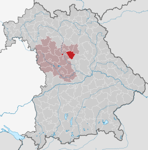
| Location of the district of Nuremberg in Bavaria | ||
  |
||

The district of Nuremberg belonged to the Bavarian administrative district of Middle Franconia . Before the Bavarian regional reform began in the early 1970s, the district comprised 35 municipalities.
geography
Important places
The most populous communities were Altdorf , Feucht , Burgthann , Stein and Schwarzenbruck .
Neighboring areas
In 1972 the district bordered in a clockwise direction in the northwest on the districts of Erlangen , Lauf an der Pegnitz , Hersbruck , Neumarkt in der Oberpfalz , Schwabach , on the independent city of Nuremberg and with the exclusive municipality of Stein on the district of Fürth .
history
District Office
The district office of Nuremberg was formed in 1862 through the merger of the older district courts Altdorf and Nuremberg .
On January 1, 1895, the Nuremberg District Office took over the municipality of Hagenhausen from the Neumarkt District Office in Upper Palatinate .
The municipality of Sündersbühl was incorporated into the city of Nuremberg on January 1, 1898. On the same day, the Nuremberg District Office ceded the communities of Breitenbrunn , Kucha and Offenhausen to the Hersbruck District Office .
On January 1, 1899, the municipalities of Erlenstegen , Gibitzenhof , Gleißhammer , Großreuth near Schweinau , Großreuth behind the fortress , Höfen , Kleinreuth behind the fortress , Mögeldorf , Schniegling , Schoppershof , Schweinau , Thon and Wetzendorf came to the city of Nuremberg.
On January 1, 1900, the municipality of Eismannsberg was reclassified from the Neumarkt District Office in the Upper Palatinate to the Nuremberg District Office.
On August 1, 1920, the municipality of Ziegelstein was incorporated into Nuremberg. On November 1, 1923, the municipalities Almoshof , Lohe and Zerzabelshof followed .
Part of the municipality of Deutenbach of the Schwabach district office was incorporated into the city of Nuremberg on June 15, 1922. The remaining part moved to the district office of Nuremberg and came to the community of Stein near Nuremberg .
The municipality of Laufamholz has been part of the city of Nuremberg since April 1, 1938 .
district
On January 1, 1939, the uniform imperial designation Landkreis was introduced. Thus the district office became the district of Nuremberg.
On July 1, 1972, the district of Nuremberg was dissolved as part of the regional reform in Bavaria . Its largest part was added to the district of Lauf an der Pegnitz together with the then Hersbruck district . The municipality of Stein, located as an exclave in the west of the city of Nuremberg , became part of the Fürth district ; the communities Fischbach (with Altenfurt and Moorenbrunn ) and Brunn (with Netzstall and Birnthon ) were incorporated into the city of Nuremberg. The city of Nuremberg itself remained independent .
Initially, the district was given the name Lauf an der Pegnitz and on May 1, 1973 the name still valid today, the district of Nürnberger Land .
Population development
| year | Residents | source |
|---|---|---|
| 1864 | 29,050 | |
| 1885 | 47,755 | |
| 1900 | 20,416 | |
| 1910 | 23,296 | |
| 1925 | 22,701 | |
| 1939 | 29,290 | |
| 1950 | 43,593 | |
| 1960 | 50,600 | |
| 1971 | 69,700 |
Communities
Places in italics are still independent communities today. In the places that are no longer independent today, it is noted which municipality the place belongs to today.
The community Weihersbuch was incorporated into Stein near Nuremberg on January 1, 1927.
License Plate
On July 1, 1956, the district was assigned the distinctive sign N when the vehicle registration number that is still valid today was introduced . It is still issued in the city of Nuremberg to this day. In the district of Nürnberger Land it was issued until August 3, 1974. It has been available there again since July 15, 2013 due to the license plate liberalization .
literature
- August Gebeßler : District of Nuremberg (= Bavarian art monuments . Volume 11 ). Deutscher Kunstverlag, Munich 1961, DNB 451450981 .
- Hanns Hubert Hofmann : Nuremberg-Fürth (= Historical Atlas of Bavaria, part Franconia I, 4). Commission for Bavarian State History, Munich 1954, DNB 452071224 ( digitized version ).
Individual evidence
- ^ Official register of places for Bavaria 1964
- ^ Wilhelm Volkert (ed.): Handbook of Bavarian offices, communities and courts 1799–1980 . CH Beck, Munich 1983, ISBN 3-406-09669-7 , p. 542 .
- ^ Wilhelm Volkert (ed.): Handbook of Bavarian offices, communities and courts 1799–1980 . CH Beck, Munich 1983, ISBN 3-406-09669-7 , p. 97 .
- ^ Federal Statistical Office (ed.): Historical municipality directory for the Federal Republic of Germany. Name, border and key number changes in municipalities, counties and administrative districts from May 27, 1970 to December 31, 1982 . W. Kohlhammer, Stuttgart / Mainz 1983, ISBN 3-17-003263-1 , p. 724 .
- ^ Federal Statistical Office (ed.): Historical municipality directory for the Federal Republic of Germany. Name, border and key number changes in municipalities, counties and administrative districts from May 27, 1970 to December 31, 1982 . W. Kohlhammer, Stuttgart / Mainz 1983, ISBN 3-17-003263-1 , p. 719 .
- ^ Eugen Hartmann: Statistics of the Kingdom of Bavaria . Ed .: Royal Bavarian Statistical Bureau. Munich 1866, population figures of the district offices 1864 ( digitized version ).
- ↑ Royal Bavarian Statistical Bureau (ed.): Localities directory of the Kingdom of Bavaria . Munich 1888, population figures of the district offices 1885 ( digitized ).
- ↑ a b www.gemeindeververzeichnis.de: Middle Franconia
- ^ Localities directory for the Free State of Bavaria, based on the census of June 16, 1925
- ↑ Statistical Yearbook for the German Reich 1940
- ↑ Statistical Yearbook for the Federal Republic of Germany 1952
- ↑ Statistical Yearbook for the Federal Republic of Germany 1961
- ↑ Statistical Yearbook for the Federal Republic of Germany 1973
Aichach | Alzenau i.UFr. | Amberg | Bad Aibling | Bad Neustadt adSaale | Bad Toelz | Beilngries | Berchtesgaden | Bow | Brückenau | Burglengenfeld | Dingolfing | Dinkelsbühl | Donauwörth | Ebermannstadt | Boars | Eggenfelden | Erlangen | Eschenbach idOPf. | Feuchtwangen | Friedberg | Feet | Gemünden a.Main | Gerolzhofen | Grafenau | Griesbach i.Rottal | Gunzenhausen | Hammelburg | Hassfurt | Hersbruck | Hilpoltstein | Höchstadt adAisch | Hofheim i.UFr. | Illertissen | Ingolstadt | Karlstadt | Kaufbeuren | Kemnath | Kempten (Allgäu) | Königshofen i.Grabfeld | Kötzting | Krumbach (Swabia) | Landau adIsar | Lauf adPegnitz | Running | Lohr a.Main | Mainburg | Mallersdorf | Marktheidenfeld | Marktoberdorf | Mellrichstadt | Memmingen | Mindelheim | Münchberg | Nabburg | Naila | Neuburg adDonau | Neunburg vorm Wald | Neustadt adAisch | Nordlingen | Nuremberg | Obernburg am Main | Oberviechtach | Ochsenfurt | Parsberg | Pegnitz | Parish churches | Rehau | Riedenburg | Roding | Rothenburg ob der Tauber | Rottenburg adLaaber | Scheinfeld | Schongau | Schrobenhausen | Schwabach | Schwabmünchen | Sonthofen | Stadtsteinach | Staffelstein | Straubing | Sulzbach-Rosenberg | Uffenheim | Viechtach | Vilsbiburg | Vilshofen | Vohenstrauss | Waldmünchen | Wasserburg a.Inn | Wegscheid | Weilheim i.OB | Weißenburg i.Bay. | Wertingen | Wolfratshausen | Wolfstein
1939–1945 affiliated districts: Bergreichenstein | Eisenstein market | Prachatitz