Winkelhaid
| coat of arms | Germany map | |
|---|---|---|

|
Coordinates: 49 ° 23 ' N , 11 ° 18' E |
|
| Basic data | ||
| State : | Bavaria | |
| Administrative region : | Middle Franconia | |
| County : | Nuremberg country | |
| Height : | 427 m above sea level NHN | |
| Area : | 6.45 km 2 | |
| Residents: | 4296 (Dec. 31, 2019) | |
| Population density : | 666 inhabitants per km 2 | |
| Postal code : | 90610 | |
| Area code : | 09187 | |
| License plate : | LAU, ESB , HEB, N , PEG | |
| Community key : | 09 5 74 164 | |
| LOCODE : | DE YWB | |
| Community structure: | 4 parts of the community | |
| Address of the municipal administration: |
Penzenhofener Strasse 1 90610 Winkelhaid |
|
| Website : | ||
| Mayor : | Michael Schmidt ( CSU ) | |
| Location of the municipality Winkelhaid in the district of Nürnberger Land | ||
Winkelhaid is a municipality in the central Franconian district of Nürnberger Land .
geography
Geographical location
The community is located about 18 km southeast of Nuremberg on the eastern edge of the Lorenzer Reichswald , in the transition area from the Middle Franconian Basin to the foreland of the Middle Franconian Alb.
Community structure
The community has 4 districts :
- Penzenhofen (today grown together with the main town)
- Richthausen (also grown together with the main town)
- Ungelstetten (an enclave north of the BAB 6 )
- Winkelhaid
Neighboring communities
Neighboring communities are (starting in the north clockwise): Altdorf near Nuremberg , Schwarzenbruck and Feucht .
Flowing waters
The following three rivers are located in the municipality:
- Ebenbach : The 3rd order flowing water has its headwaters west of Weinhof and flows through several chains of ponds southeast of Penzenhofen before the stream joins the Hennertsmühlgraben west of Hahnhof and forms the Gauchsbach . Like the Röstbach, the flowing water falls partially or completely dry in summer. The catchment area of the Ebenbach and Röstbach is mainly determined by Lias ( Black Jura ) and Feuerletten. The biocenotic types of water bodies Ebenbach and Röstbach correspond to the category of carbonate, fine to coarse material rich low mountain rivers of the Keuper .
- Röstbach (Röst): The source area of the 3rd order flowing water is in the east of Winkelhaid in the agricultural corridor. The water flows in an east-west direction. In the center of the village, the small stream is dammed into a pond at the town hall. The Röstbach flows into the Ebenbach to the west of Winkelhaid within the Reichswald. The Röstbach is continuously regulated and built in the settlement area.
- Röthenbach : The river flows to the west of Ungelstetten and has a total of over 21 km long water course. The biocenotic water type corresponds to the category of fine material rich, carbonate low mountain streams of the Keuper.
geology
The municipality of Winkelhaid is geologically essentially shaped by Lias layers (Black Jura). The area around Ungelstetten also has Quaternary drift sand over Keuper and Lias deposits. In the northeast part of Ungelstetten, Feuerletten from the Keuper appear. Small-scale occurrences of Feuerletten ( Trossingen formation ) are also present in the area of the flowing waters of Ebenbach and Röst in the east of Winkelhaid. Quaternary valley fillings with alluvial sand can be observed along the Röthenbach .
climate
With its humid climate, Winkelhaid lies in the cool, temperate climate zone . The community is located in the transition area between the humid Atlantic and dry continental climates . According to the Köppen-Geiger climate classification, Franconia, including Winkelhaid, belongs to the warm, temperate rainy climate (Cfb climate). The mean air temperature of the warmest month remains below 22 ° C and that of the coldest month above -3 ° C.
The average annual rainfall is 693 mm, with an overweight in summer. June is the wettest month with 81 mm. The wettest month is February with 41 mm. Over the entire year, the average temperature is 8.2 ° C. From a climatological point of view, July is the warmest month of the year with an average of 17.5 ° C. The lowest temperatures are recorded in January with an average of -1.3 ° C.
|
Average monthly temperatures and precipitation for Winkelhaid
Source:
|
|||||||||||||||||||||||||||||||||||||||||||||||||||||||||||||||||||||||||||||||||||||||||||||||||||||||||||||||||||||||||||||||||||||||||||||||||||||||||||||||||||||
Land use
| use | Hectares |
|---|---|
| Area of residential areas | 102 |
| traffic area | 55 |
| Forest area | 172 |
| Agricultural area | 302 |
| Areas of other use | 17th |
| total area | 648 |
The land use table shows a comparatively high proportion of agriculturally used land, which is 46.5 percent and thus makes up half of the municipal area. Winkelhaid is characterized by a great wealth of forests. The Reichswald takes up more than a quarter of the municipality's area, the exact proportion is 26.6 percent. The open spaces - consisting of forest and arable land - comprise almost three quarters of the Winkelhaider municipal area, the exact proportion is 73.1 percent.
The proportion of residential areas is 15.7 percent. The traffic area share is 8.5 percent.
history
The first settlement activities in the municipal area are documented by archaeological finds for the period between 1040 and 1050 AD. The first written mention of Winkelhaid comes from the year 1274.
At the beginning of the 16th century, there were already 50 properties for Winkelhaid. At the end of the 18th century, around 380 people lived in the village. The opening of the Nuremberg-Feucht-Winkelhaid-Altdorf railway line (1878) brought new opportunities, as many Winkelhaid people found jobs in Nuremberg.
Population development
In 1925 there were 724 inhabitants. After the Second World War , the place grew due to the influx of refugees and displaced persons, so that the population grew to 1,388 inhabitants by 1950. Due to the decline in agriculture, fields were converted into building land, and in 1976 the 3,000-inhabitant limit was reached. In 2017 Winkelhaid had 4,274 inhabitants, with a population density of 674 inhabitants per square kilometer.

Incorporations
On January 1, 1972, the main town of Penzenhofen was incorporated into the disbanded municipality of the same name.
politics
Municipal council
The Winkelhaid municipal council consists of 16 councilors and the first mayor.
| CSU | SPD | Green | FWG | UWA *) | total | |
| 2020 | 9 | - | 3 | 3 | 2 | 16 seats |
| 2014 | 9 | 3 | 2 | 2 | 1 | 16 seats |
| 2008 | 9 | 4th | 2 | 2 | 16 seats |
(Status: local election on March 15, 2020)
Explanation: *) Independent Winkelhaider alternative
mayor
Michael Schmid (CSU) has been the mayor since May 2008.
coat of arms
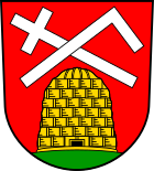
The Winkelhaider coat of arms shows a golden beehive in red on a green ground, above it a silver cross bar and a silver angle are shown.
The angle symbolizes the place name , which stands for Heide im Winkel. The beehive indicates the historical Zeidelgüter and the associated forest beekeeping. The location in the Reichswald offered suitable conditions for this. The cross staff is considered the attribute of Saint John, to whom the church in Penzenhofen was also consecrated.
Town twinning
- The village of Teis in South Tyrol
- The rural community of Apc in Northern Hungary
Culture and sights
Architectural and ground monuments
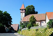
Parish Church of St. John the Baptist
The parish church of St. John the Baptist was built around 1400 in the Gothic style.
A hall with a rectangular, slightly drawn-in choir and a striking west tower with a pointed helmet characterize the Evangelical Lutheran church . In 1690/91 the building was extensively restored. The tower top floor and half-timbering were renewed in 1948.
The church was used as the student chapel of the theological faculty of the University of Altdorf . Budding theologians gave their first sermons here.
park
Sedansgärtlein
The green area known as Sedansgärtlein is located in the center of Winkelhaid between Penzenhofener Straße and Richthausener Straße. The triangular small garden was planted with so-called memorial and peace trees in 1648 on the occasion of the Peace of Westphalia and in 1871 when the German Empire was founded . Two linden trees that characterize the townscape and an oak are a central design element of the complex. A war memorial that was erected in 1922 is located in the middle of the grove of trees. The Sedansgärtlein was under nature protection from 1910 to 1995.
Protected areas
The lichen-pine forest nature reserve is located north of Winkelhaid, south of Leinburg . To the northeast is the natural monument and geotope Röthenbachklamm .
The EU bird sanctuary of Nuremberg Reichswald is located to the west of the Winkelhaid settlement area . White moss pine forests dominate here with lingonberries and blueberries as the understory. Moss, heather and very small areas of lichen also form the ground vegetation.
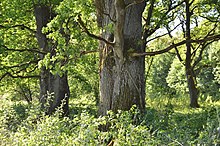
In the south-east of the municipality, on State Road 2239, there is an old hutanger with old oaks. This oak grove near Penzenhofen was designated as a protected landscape component due to its cultural and historical significance .
traffic
In the northeast Winkelhaid is from the motorway A 3 touches. There is a driveway at Altdorf (AS 90). The state road St 2239 connects the Penzenhofen district with Feucht or Altdorf.
Winkelhaid is connected to the Nuremberg S-Bahn with a single-track stop on the northern outskirts . The travel time to Nuremberg Central Station, 19.6 kilometers away by rail, is 23 minutes. At the weekend Winkelhaid is approached by night buses from Nuremberg (with a change in Feucht).
education
The Winkelhaid / Penzenhofen primary school with grades one to four had two locations in Winkelhaid and in Penzenhofen. The 1957 school building in Winkelhaid was demolished in May 2016.
The secondary grades five to nine of the secondary school are offered in Feucht and Altdorf. The next secondary school is also in Feucht, the next grammar school in Altdorf.
The administration of the Volkshochschule Schwarzachtal is housed in the Winkelhaid town hall.
literature
- Johann Kaspar Bundschuh : Winckelhaid . In: Geographical Statistical-Topographical Lexicon of Franconia . tape 6 : V-Z . Verlag der Stettinische Buchhandlung, Ulm 1804, DNB 790364328 , OCLC 833753116 , Sp. 255 ( digitized version ).
- Dieter Trautmann: Winkelhaid near Nuremberg: Active, livable and lovable . 1st edition. Geiger-Verlag, Horb am Neckar 1995, ISBN 978-3-89570-107-8 .
- Dieter Trautmann: Winkelhaid near Nuremberg in pictures - the day before yesterday, yesterday, today . Ed .: Municipality of Winkelhaid. Geigerdruck GmbH, Horb am Neckar 1985, ISBN 3-924932-34-4 .
- Eckhardt Pfeiffer (Ed.): Nürnberger Land . 3. Edition. Karl Pfeiffer's Buchdruckerei und Verlag, Hersbruck 1993, ISBN 3-9800386-5-3 .
Web links
- Winkelhaid municipality
- Entry on Winkelhaid's coat of arms in the database of the House of Bavarian History
Individual evidence
- ↑ "Data 2" sheet, Statistical Report A1200C 202041 Population of the municipalities, districts and administrative districts 1st quarter 2020 (population based on the 2011 census) ( help ).
- ^ Community Alfeld in the local database of the Bayerische Landesbibliothek Online . Bayerische Staatsbibliothek, accessed on December 25, 2019.
- ↑ a b Max Wehner: Water development concept for the municipality of Winkelhaid (third order of water). (PDF) September 2015, accessed on August 23, 2017 .
- ↑ UmweltAtlas Bayern: Geology. Bavarian State Office for the Environment (LfU), accessed on August 30, 2017 .
- ↑ BayernAtlas - the map viewer of the Free State of Bavaria with maps, aerial photos and a variety of themed maps. Bavarian Surveying Administration, accessed on August 29, 2017 .
- ↑ Climate & weather in Winkelhaid. Climate-Data.org, accessed on August 23, 2017 .
- ↑ Climate-Data.org
- ↑ a b portrait - Winkelhaid. Winkelhaid municipality, 2018, accessed on February 10, 2018 .
- ↑ a b Media Agency Schmidt / Municipality Winkelhaid (ed.): Municipality Winkelhaid . 1st edition. 2016, p. 9 .
- ↑ a b Municipality of Winkelhaid 09 574 164: A selection of important statistical data. In: Statistics Kommunal 2018. Bavarian State Office for Statistics, January 31, 2019, accessed on May 30, 2020 .
- ^ Wilhelm Volkert (ed.): Handbook of Bavarian offices, communities and courts 1799–1980 . CH Beck, Munich 1983, ISBN 3-406-09669-7 , p. 542 .
- ↑ Municipal council members , on winkelhaid.de
- ↑ wahlen.bayern.de
- ↑ a b Entry on Winkelhaid's coat of arms in the database of the House of Bavarian History , accessed on November 18, 2017 .
- ↑ List of monuments for Winkelhaid. (PDF) Bavarian State Office for Monument Preservation, August 26, 2017, accessed on August 29, 2017 .
- ↑ www.protectedplanet.net, Nürnberger Reichswald (accessed on August 11, 2017)
- ↑ 6533-471 Nuremberg Reichswald. (EU bird sanctuary) Profiles of the Natura 2000 areas. Published by the Federal Agency for Nature Conservation . Retrieved November 18, 2017.
- ↑ Ordinance on the protected part of the landscape "Eichenhain bei Penzenhofen", Winkelhaid municipality. In: Regulation. District of Nürnberger Land, November 13, 1998, accessed on July 2, 2020 .
- ↑ N-Land, Winkelhaider school building gives way to a residential complex ( memento from September 10, 2016 in the Internet Archive ) (accessed on May 26, 2016)
- ^ Volkshochschule Schwarzachtal


