
Leinburg (municipality-free area)

The community-free area of Leinburg is a community-free area in the central Franconian district of Nürnberger Land in Bavaria .
The 4.20 km² state forest is located south of the community of Leinburg . A nameless mountain ( 49 ° 25 ′ 59.7 ″ N , 11 ° 19 ′ 19.7 ″ E ) is 387 m above sea level. NHN the highest point in the area. Within the area there are two enclaves , both of which belong to the community of Leinburg, namely the forester's house in Leinburg on the one hand and a piece of forest in the central area on the other. A large part is part of the EU bird sanctuary area Nuremberg Reichswald .
Waters
A right tributary of the Röthenbach runs in the north, partly as a border, partly within the Haidelbach area .
Worth seeing
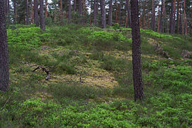
The area is characterized by local pine forests (Steckalas forest) which are criss-crossed by bike, hiking and riding trails. The Franconian Dune Trail also crosses the area.
The majority is made up of the lichen-pine forest nature reserve south of Leinburg . In the south-west, the original valley with its ponds forms the border with the community of Leinburg .
Picture gallery

Typical Steckalas forest
Sand dune in the NSG
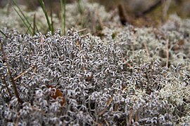
Lichen in the NSG

Speckweiher in the Original Valley


See also
Individual evidence
- ↑ Area information at www.destatis.de, as of December 31, 2018 , accessed on August 1, 2020.
- ↑ Exclave of the community of Leinburg
- ↑ www.protectedplanet.net, Nürnberger Reichswald (accessed on November 25, 2017)
- ↑ Natura 2000: DE6533471, Nürnberger Reichswald (accessed on November 25, 2017)
Web links
- Community-free area of Leinburg in OpenStreetMap (accessed on March 15, 2015)
- 6533-471 Nuremberg Reichswald. (EU bird sanctuary) Profiles of the Natura 2000 areas. Published by the Federal Agency for Nature Conservation .

Alfeld | Altdorf near Nuremberg | Burgthann | Engelthal | Damp | Happurg | Hartenstein | Henfenfeld | Hersbruck | Kirchensittenbach | Lauf an der Pegnitz | Leinburg | Neuhaus an der Pegnitz | Neunkirchen am Sand | Offenhausen | Ottensoos | Pommelsbrunn | Reichenschwand | Röthenbach an der Pegnitz | Rückersdorf | Schnaittach | Schwaig near Nuremberg | Schwarzenbruck | Simmelsdorf | Velden | Provision | Winkelhaid
Unregulated areas:
Behringersdorfer Forst |
Brunn |
Engelthaler Forest |
Moist forest |
Fischbach |
Forsthof |
Günthersbühler Forest |
Haimendorfer Forest |
Laufamholzer Forest |
Leinburg |
Rückersdorfer Forst |
Schoenberg |
Winkelhaid |
Zerzabelshofer Forest
Coordinates: 49 ° 26 ' N , 11 ° 18' E