Velden (Pegnitz)
| coat of arms | Germany map | |
|---|---|---|

|
Coordinates: 49 ° 37 ' N , 11 ° 31' E |
|
| Basic data | ||
| State : | Bavaria | |
| Administrative region : | Middle Franconia | |
| County : | Nuremberg country | |
| Management Community : | Velden | |
| Height : | 377 m above sea level NHN | |
| Area : | 21.32 km 2 | |
| Residents: | 1822 (Dec. 31, 2019) | |
| Population density : | 85 inhabitants per km 2 | |
| Postal code : | 91235 | |
| Area code : | 09152 | |
| License plate : | LAU, ESB , HEB, N , PEG | |
| Community key : | 09 5 74 160 | |
| City structure: | 8 districts | |
City administration address : |
Marktplatz 9 91235 Velden |
|
| Website : | ||
| First Mayor : | Herbert Seitz ( SPD / Velden Free Voters' Association) | |
| Location of the city of Velden in the district of Nürnberger Land | ||
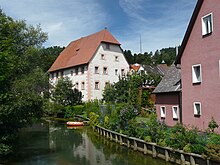
Velden is a town in the central Franconian district of Nürnberger Land and the seat of the Velden administrative association .
geography
The city is located in the upper Pegnitz Valley in the Hersbrucker Alb , about 38 km northeast of Nuremberg .
City structure
Velden has eight districts (population figures in brackets as of November 1, 2018):
|
|
Neighboring communities
The neighboring communities are Plech , Neuhaus an der Pegnitz , Hartenstein , Kirchensittenbach and Betzenstein, starting in the north and clockwise .
history
Until the 19th century
So far, there is no reliable knowledge about the origin of the town, which is conveniently located on important north-south connections through the central Franconian Jura. Like other places with the suffix field in the East Franconian-Bavarian border area, the place name suggests a foundation during the Carolingian era. The fact that the room was owned by the Bavarian dukes up to the year 788, as can often be read in accounts of local history, cannot be proven and is rather unlikely from a rulership-historical perspective. The first written mention of Velden comes from the year 889, when the Carolingian Emperor Arnulf of Carinthia issued a certificate there on his journey from Forchheim to Regensburg. This suggests a royal court on the important land connection from the Palatinate town of Forchheim around the important rulership center Sulzbach to Regensburg. This is likely to have been the center of a large royal forestis , a use and forest district in royal hands. The donation of a church in Velden to the Eichstätter Bishop Erchanbald by the East Franconian King Konrad I also points in this direction . The parish church of St. Maria is likely to go back to the church of the Carolingian royal court.
In 1009 Velden and the associated forestis were given to the bishop of the newly created diocese of Bamberg as part of extensive royal donations from King Heinrich II . In the 11th and 12th centuries, the place belonged to the domain of the Counts of Sulzbach, who served as Bamberg bailiffs in this area. During the High Middle Ages, the Bamberg bishops built the so-called New House, today's Veldenstein Castle above Neuhaus an der Pegnitz, in what was left of them .
In the 14th century, Velden belonged for some time to the New Bohemian possessions of Emperor Charles IV , who granted the town town rights in 1376. After it fell back to the Bavarian House of Wittelsbach in 1401 , Velden largely sank again into insignificance.
During the Landshut War of Succession , the place was taken over several times by the conflicting parties involved. After this war was ended in July 1505 with the Cologne arbitration ruling by King Maximilian , the city and the office belonging to it became the property of the Imperial City of Nuremberg and were subsequently incorporated into its rural area as the Velden Care Office.
The part of the nursing office east of the Pegnitz was forcibly taken possession of by the Electorate of Bavaria with the help of largely questionable legal titles towards the end of the 18th century . This happened after Elector Karl Theodor von Pfalz-Baiern in 1790 terminated all treaties and agreements that had been concluded between the imperial city and the Palatinate and Bavaria since the Peace of Cologne in 1505. The part of the nursing office located west of the Pegnitz with the city itself, however, shared the fate of the imperial city until it was annexed by the Kingdom of Bavaria in 1806 .
Incorporations
On January 1, 1972, the previously independent communities Viehhofen and Treuf were (partially) incorporated into the city of Velden as part of the regional reform in Bavaria .
Origin of name
The place name Velden, which is often used in its basic form in Upper Germany and occurs very numerous in compound words, goes back to the Germanic word field (flat surface, field, field), which was already attested in Old High German . The oldest mention of the place from the year 889 handed down the name form "Feldun", which can be translated with or about the fields.
politics
Municipal council
The city council consists of 12 city councilors and the first mayor. In the local elections on March 16, 2014 the parliamentary group CSU / Free Citizens Velden received five (previously 6) seats with 39.1% of the votes (2008: 52.3%), the parliamentary group from SPD / Free Velden Velden got one Share of votes of 60.9% (2008: 47.7%) seven (previously 6) seats. The turnout in 2014 was 63.1%.
mayor
The professional first mayor is Herbert Seitz (SPD / Freie Wählervereinigung Velden), who won against Christa Begert (CSU) (43.3%) in 2008 with 56.7% of the votes cast. In the 2014 local election he was confirmed in office with 97.9% of the valid votes and in the 2020 local election with 94.5%. Seitz's predecessor was Herbert Begert.
Town twinning
-
 In 1990 Velden signed a town partnership with Jöhstadt in the Erzgebirgskreis ( Saxony ).
Attractions
- The city tower built in the first half of the 15th century is still completely intact. The year 1516 on the east side indicates the year of the renovation. The tower is twelve meters high and has a floor plan of about 6 × 6 meters. It is closed off by a mighty hipped roof on which a bell tower sits. There are three floors above the round arch of the passage, which were rebuilt after being destroyed in the war in 1960. In 2004 the outer facade was refurbished, in 2005 the tower received the monument award of the district of Middle Franconia.
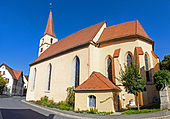
- The Evangelical Lutheran parish church of St. Maria is a hall church built around 1350/70 with a retracted, cross-rib vaulted choir. The richly painted and sculptural furnishings from the late 15th and early 16th centuries are particularly interesting. The ceiling painting with the Ascension of Christ was created during the church renovation in 1926.
- Further sights are the former care castle, the rectory, the Scheunenviertel and part of the old city wall with the Mühltor.
nature
caves
There are several natural karst caves in the municipality of Velden . In addition to the two well-known Geisloch and Appenloch caves near Münzinghof, the following caves are worth a visit.
Big and Small Rohenloch
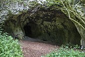
Both caves are located about 800 meters northeast of Viehhofen in the Kupfertal. The Großer Rohenloch is a half-cave with a total length of about 70 meters. The cave is registered as D 18 in the Franconian Alb cave cadastre (HFA) and designated as geotope 574H013 by the Bavarian State Office for the Environment . See also the list of geotopes in the district of Nürnberger Land . Excavation finds have shown that the cave was already inhabited in the Neolithic Age. The Kleine Rohenloch is about 50 meters away from the Großer Rohenloch. The small cave is about 12 meters long and registered in the HFA as D 17.
Space grotto
About 250 meters east of the Großer Rohenloch is the 25-meter-long room grotto, which is registered in the HFA as D 164.
Geisloch
The Geisloch or Geishöhle is a natural karst cave near Münzinghof.
traffic
The federal highway 9 runs northwest of Velden; the Hormersdorf and Plech junctions are each about ten kilometers away.
Velden belongs to the transport association for the greater Nuremberg area . Regional trains of DB Regio AG on the Nuremberg - Neuhaus an der Pegnitz line stop every hour at the Velden (b Hersbruck) train station on the Nuremberg – Cheb line .
Personalities
sons and daughters of the town
- Adam Rudolf Solger (1693–1770), Antistes, librarian and book collector in Nuremberg
literature
- Nuremberg country . Karl Pfeiffer's Buchdruckerei und Verlag, Hersbruck 1993. ISBN 3-9800386-5-3
- Johann Kaspar Bundschuh : Velden . In: Geographical Statistical-Topographical Lexicon of Franconia . tape 6 : V-Z . Verlag der Stettinische Buchhandlung, Ulm 1804, DNB 790364328 , OCLC 833753116 , Sp. 9-10 ( digitized version ).
- Pleikard Joseph Stumpf : Velden . In: Bavaria: a geographical-statistical-historical handbook of the kingdom; for the Bavarian people . Second part. Munich 1853, p. 734 ( digitized version ).
Web links
- Official website of the city
- Entry on the coat of arms of Velden (Pegnitz) in the database of the House of Bavarian History
Individual evidence
- ↑ "Data 2" sheet, Statistical Report A1200C 202041 Population of the municipalities, districts and administrative districts 1st quarter 2020 (population based on the 2011 census) ( help ).
- ↑ a b c Mayor / Lord Mayor in municipalities belonging to the district (as of May 1st, 2020). (xlsx) Bavarian State Office for Statistics, accessed on June 20, 2020 .
- ↑ Population of the districts
- ^ Wilhelm Volkert (ed.): Handbook of Bavarian offices, communities and courts 1799–1980 . CH Beck, Munich 1983, ISBN 3-406-09669-7 , p. 481 .
- ^ Website City of Velden - City Council
- ↑ a b Veldens architectural monuments worth seeing
- ↑ Geotope: Large Rohenloch near Viehhofen (accessed on October 1, 2013; PDF; 168 kB)


