Engelthal
| coat of arms | Germany map | |
|---|---|---|

|
Coordinates: 49 ° 28 ' N , 11 ° 24' E |
|
| Basic data | ||
| State : | Bavaria | |
| Administrative region : | Middle Franconia | |
| County : | Nuremberg country | |
| Management Community : | Henfenfeld | |
| Height : | 371 m above sea level NHN | |
| Area : | 13.62 km 2 | |
| Residents: | 1085 (Dec. 31, 2019) | |
| Population density : | 80 inhabitants per km 2 | |
| Postal code : | 91238 | |
| Area code : | 09158 | |
| License plate : | LAU, ESB , HEB, N , PEG | |
| Community key : | 09 5 74 120 | |
| Community structure: | 6 parts of the community | |
| Address of the municipal administration: |
Hauptstrasse 41 91238 Engelthal |
|
| Website : | ||
| First Mayor : | Günther Rögner ( CSU ) | |
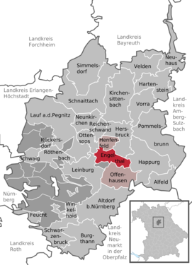
| Location of the community Engelthal in the district of Nürnberger Land | ||
Engelthal is a municipality in the Middle Franconian district of Nürnberger Land and belongs to the Henfenfeld administrative community . The place is in the heart of the Franconian Alb .
geography
Community structure
The community has 6 districts :
- Engelthal
- Krönhof
- Kruppach
- Peuerling
- Prosberg
- Sendelbach
Neighboring communities
Neighboring communities are (starting clockwise in the north): Henfenfeld , Hersbruck , Happurg , Offenhausen , Leinburg , Ottensoos . Nuremberg is 34 kilometers away by car.
history
Early history
In 1243 the village of Swinach became the seat of the Dominican convent Engelthal . From 1289 to 1356 Christine Ebner lived in Engelthal Monastery , who processed her numerous visions and revelations and those of her fellow sisters in literature ( Life and Revelations , from 1317 and Engelthaler sister book , before 1346). Because of her life and work, she was one of the notable women of the first half of the 14th century. Engelthal is known for this monastery, which in the 14th century was a center of mystical spirituality and an almost unique production of German-language mystical literature. In the following years the monastery expanded only slightly in the local area and in 1504 came into the possession of the imperial city of Nuremberg . In the course of the Reformation , the monastery was abandoned in 1565, and Engelthal again became an insignificant place in the Nuremberg hinterland.
Incorporations
On July 1, 1972, the previously independent municipality of Sendelbach was incorporated. Kruppach followed on May 1, 1978 .
politics
Municipal council
The municipality of Engelthal is composed of twelve municipal councils and the first mayor:
| CSU | SPD | Free voters | total | |
| 2014 | 5 | 2 | 5 | 12 seats |
(As of: local elections on March 16, 2014)
mayor
Günther Rögner of the CSU has been First Mayor of Engelthal since May 1, 2002 .
coat of arms
The municipal coat of arms shows the coat of arms of the imperial city of Nuremberg and the Archangel Michael, who holds a sword and a scale.
Culture and sights
- Parish church of St. John the Baptist: built around 1270, redesigned in Baroque style from 1747 to 1751
- Chapel ruin St. Willibald: built in the 14th century, profaned in 1811, restored and reopened on July 7, 2005 as a communicative meeting point for the community
- Engelthal Monastery : Only remnants of the complex are left. An association tries to restore the monastery wall.
- On the northeast slope of the Buchenberg there is the remarkable stone channel on the Buchenberg .
- The volunteer fire brigade has existed since 1883 .
- The parish fair takes place annually on the last weekend in June, the weekend after St. John's Day.
To the west of the village on the LAU 7 district road there are two stone crosses . The stone cross at the Engelthal sports field and the cross stone near Peuerling are replicas of the originally badly damaged originals.
Local institutions
- Frankenalb Clinic Engelthal , since 1973 a specialist clinic for psychiatry, psychotherapy and psychosomatics
Sons and daughters of the church
- Christine Ebner (1277–1356), German Dominican and mystic
- Friedrich Sunder (1254–1328), monastery chaplain in the Dominican convent Engelthal
- Adelheid Langmann (1306–1375), nun and mystic
- Konrad von Füssen , Dominican priest
literature
- Johann Kaspar Bundschuh : Engelthal . In: Geographical Statistical-Topographical Lexicon of Franconia . tape 2 : El-H . Verlag der Stettinische Buchhandlung, Ulm 1800, DNB 790364298 , OCLC 833753081 , Sp. 21-22 ( digitized version ).
- Leonard Patrick Hindsley: The Mystics of Engelthal: Writings from a Medieval Monastery . Palgrave MacMillan, New York 1998, ISBN 978-0312162511
- Eckhardt Pfeiffer: Nürnberger Land . Karl Pfeiffer's Buchdruckerei und Verlag, Hersbruck 1993, ISBN 3-9800386-5-3 .
- Pleikard Joseph Stumpf : Engelthal . In: Bavaria: a geographical-statistical-historical handbook of the kingdom; for the Bavarian people . Second part. Munich 1853, p. 686 ( digitized version ).
- Gustav Voit: Engelthal. History of a Dominican convent in the Nuremberg area. 2 vols. Korn & Berg, Nuremberg 1977/78 (series of publications of the Altnürnberger Landschaft XXVI)
Web links
- Homepage
- On the history of the Engelthal site and monastery
- On the history of Engelthal Monastery (PDF; 1.1 MB)
- Engelthal: Official statistics of the LfStat
- Customs in Engelthal
Individual evidence
- ↑ "Data 2" sheet, Statistical Report A1200C 202041 Population of the municipalities, districts and administrative districts 1st quarter 2020 (population based on the 2011 census) ( help ).
- ^ Greetings from the mayor of Engelthal. Engelthal parish, accessed on June 25, 2020 .
- ^ Community Engelthal in the local database of the Bavarian State Library Online . Bayerische Staatsbibliothek, accessed on December 25, 2019.
- ^ Wilhelm Volkert (ed.): Handbook of Bavarian offices, communities and courts 1799–1980 . CH Beck, Munich 1983, ISBN 3-406-09669-7 , p. 481 .
- ^ Entry on the coat of arms of Engelthal in the database of the House of Bavarian History


