
Forsthof (community-free area)

The community-free area Forsthof is located in the central Franconian district of Nürnberger Land .
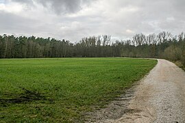
The 7.43 km² large state forest is the part of the Lorenzer Reichswald located northwest of Fischbach and east of the Nuremberg districts Langwasser and Zerzabelshof . The federal highway 4 forms the southwest border. The Bärenbühl ( 49 ° 26 '7.76 " N , 11 ° 11' 37.28" O ) is 360 m above sea level. NN the highest elevation. The area is part of the EU bird sanctuary area Nuremberg Reichswald .
Waters
The Fischbach flows through the area from east to west . Hutgraben , Tiefer Graben and Schwarzer Graben flow into the Fischbach in the area. The ice pond is to the west of Fischbach ( 49 ° 25 ′ 32 ″ N , 11 ° 10 ′ 30 ″ E ). The Holzweiher is roughly in the middle of the area ( 49 ° 25 ′ 54 ″ N , 11 ° 9 ′ 24 ″ E ). The Fischbach flows through both ponds . The Valznerweiher lies beyond the north-western edge .
Worth seeing
The area is criss-crossed by some cycling and hiking trails.
- The Russenwiese , a clearing and former camp for Russian prisoners of war. ( 49 ° 25 ′ 54.52 ″ N , 11 ° 8 ′ 46.82 ″ E )
- Remains of the former rubble railway ( 49 ° 25 ′ 48.43 ″ N , 11 ° 9 ′ 23.8 ″ E )
- Remains of a blown up former flak battery ( 49 ° 25 ′ 11.24 ″ N , 11 ° 10 ′ 31.8 ″ E )
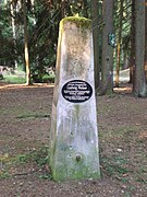
- Forest district boundary stone at the bowl stone ( 49 ° 26 ′ 17.23 ″ N , 11 ° 11 ′ 13.88 ″ E ) is this forest district boundary stone. Here Laufamholz , Brunn and Forsthof are demarcated. The triangular sandstone pillar with a niche top is designated by the Bavarian State Office for the Preservation of Monuments as an architectural monument (D-5-64-000-2245).
- Ludwig Weber Memorial, memorial stone for the murder of sergeant Ludwig Weber ( 49 ° 25 ′ 27.84 ″ N , 11 ° 10 ′ 37.67 ″ E )
- An atonement cross and a designated monument (D-5-64-000-2242) from the B8 ( 49 ° 25 ′ 13.1 ″ N , 11 ° 9 ′ 44.29 ″ E )
- A weir system, division of the Fischbach with overflow to Goldbach / Hutgraben ( 49 ° 26 ′ 5.57 ″ N , 11 ° 8 ′ 52.4 ″ E )
- The former prison at the Holzweiher ( 49 ° 26 ′ 5.86 ″ N , 11 ° 9 ′ 16.52 ″ E )
Picture gallery

The ice pond near Fischbach

The wooden pond
The Russenwiese

The Fischbacher flak battery
Ludwig Weber monument

The atonement cross on the B4
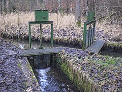
Weir system for dividing the Fischbach

Former prison


_04.jpg)


See also
- List of unincorporated areas in Bavaria
- List of architectural monuments in non-parish areas in Bavaria # Forsthof
- List of rivers in the Pegnitz river system
Individual evidence
- ↑ Area information at www.destatis.de, as of December 31, 2018 , accessed on August 1, 2020.
- ↑ www.protectedplanet.net, Nürnberger Reichswald (accessed on August 11, 2017)
- ↑ 6533-471 Nuremberg Reichswald. (EU bird sanctuary) Profiles of the Natura 2000 areas. Published by the Federal Agency for Nature Conservation . Retrieved November 27, 2017.
- ^ Bavarian State Forests, Monuments in the Nuremberg Reich Forest
- ↑ www.suehnekreuz.de, Fischbach
Web links
- Forsthof, community-free area in OpenStreetMap (accessed on May 1, 2013)

Alfeld | Altdorf near Nuremberg | Burgthann | Engelthal | Damp | Happurg | Hartenstein | Henfenfeld | Hersbruck | Kirchensittenbach | Lauf an der Pegnitz | Leinburg | Neuhaus an der Pegnitz | Neunkirchen am Sand | Offenhausen | Ottensoos | Pommelsbrunn | Reichenschwand | Röthenbach an der Pegnitz | Rückersdorf | Schnaittach | Schwaig near Nuremberg | Schwarzenbruck | Simmelsdorf | Velden | Provision | Winkelhaid
Unregulated areas:
Behringersdorfer Forst |
Brunn |
Engelthaler Forest |
Moist forest |
Fischbach |
Forsthof |
Günthersbühler Forest |
Haimendorfer Forest |
Laufamholzer Forest |
Leinburg |
Rückersdorfer Forst |
Schoenberg |
Winkelhaid |
Zerzabelshofer Forest
Coordinates: 49 ° 25 ′ 40 ″ N , 11 ° 9 ′ 20 ″ E