
Moist forest

The Feuchter Forest is a community-free area in the Middle Franconian district of Nürnberger Land in Bavaria .
description
The 20.82 km² large state forest is the part of the Lorenz Reich Forest north and east of Feucht and northwest of Schwarzenbruck . It was named after the neighboring market town of Feucht. The A6 and A9 motorways run through it and form the Nürnberg-Ost motorway junction on the northwestern border . The Nuremberg – Regensburg and Feucht – Altdorf railway lines also run through the area . At the extreme western edge is the Nürnberg Reichswald junction , the northern end of the new Nuremberg – Ingolstadt line .
The Feuchter Forest is characterized by pine stock ( plug glass forest ). The highest point is the 418 meter high Dreibrüderberg near Rummelsberg .
A large part is part of the EU bird sanctuary area Nuremberg Reichswald .
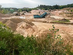
In the south-western part of the area, north of Gsteinach , there are larger economically used sand pits (as of 2017).
Waters
The area is traversed by the Gauchsbach . East of dampening it flows through a small pond, the locally Haag Weiher ( 49 ° 22 '50.52 " N , 11 ° 9' 23.29" O ) is called. In the north on the Büchleinsberg rises the Tief Graben , which becomes black water in its course and flows into the Gauchsbach in the center of Feucht. Near Moosbach are a small, enclosed in stone source, the Hubertusbrunnen ( 49 ° 23 '41.39 " N , 11 ° 14' 32.96" O ), as well as some smaller pond that used for fish farming were used.
Worth seeing
The forest is criss-crossed by a few cycling and hiking trails. The Franconian Dune Trail (signpost:) also crosses ![]() the area.
the area.
Latvian fall
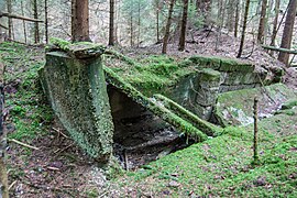
About 2 kilometers north of dampening are heavily overgrown residues of the destroyed former quarry and destroyed bunker Letts camber ( 49 ° 23 '27.96 " N , 11 ° 13' 28.85" O ). It is locally called Die Platte after the surrounding forest area .
Atonement crosses
- North is of dampening of a forest road bifurcation the Förster cross ( 49 ° 23 '17.77 " N , 11 ° 13' 45.37" O ). According to legend, it is said that a forester shot his son here out of caution.
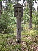
- South of wet on helben way Gsteinach is near a high-voltage swath the stone cross at Kirchbühl ( 49 ° 21 '50.33 " N , 11 ° 13' 33.82" O ).
Forest district landmarks
In order to determine the condition of the devastated forests, forest management was carried out in the Nuremberg Reichswald in 1840/41 . In this context, such forest district boundary stones (district boundary pillars) were also created. They show the adjoining area on each side. It shows forest hammers . The foresters used it to mark every single tree to prevent wood theft.
Forest district boundary stone at Hutberg
This forest district boundary stone is located east of Hutberg at a forest road intersection ( 49 ° 24 ′ 26.64 ″ N , 11 ° 13 ′ 27.52 ″ E ). Here are Fischbach , wet and Altenfurt demarcated.
Forest district boundary stone near Birnthon
This forest district boundary stone is located on the eastern edge of the community-free area at a forest road intersection ( 49 ° 24 ′ 24.12 ″ N , 11 ° 15 ′ 31.5 ″ E ). Fischbach, Feucht and Ungelstetten are demarcated here.
Others
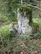
- The Black Lord , a stone column in black Bruck ( 49 ° 21 '42.12 " N , 11 ° 14' 32.17" O ). It is a devotional column made of dolomite rock. It was once provided with a picture that showed the mercy seat or the Trinity , hence the name Lord God . Since the column is near the Schwarzach , it became the Lord God on the Schwarzach. Later it became the Black Lord God.
- There is an abandoned quarry north of the hamlet of Mauschelhof .
- The memorial stone Reichswaldumbauprogramm ( 49 ° 23 ′ 7.8 ″ N , 11 ° 12 ′ 48.02 ″ E ). From 1983 to 2003, the then Bavarian State Forestry Administration planted several million deciduous trees in the Steckalas forest typical of the Reichswald . Today the Nuremberg Forestry Service of the Bavarian State Forests is continuing this work. The memorial stone that was erected consists of Worzeldorfer quartzite .
Picture gallery

The forester's cross north of Feucht
Stone cross on Kirchbühl between Feucht and Gsteinach

Former quarry with a pond near Mauschelhof
Remains of the Lettensturz bunker (Die Platte)

The Hubertus fountain near Moosbach
The Black Lord at Schwarzen-bruck

Forst-revier-Grenz-Stein am Hutberg

Imperial forest memorial stone near Feucht
Sand pit near Gsteinach


See also
- List of unincorporated areas in Bavaria
- List of ground monuments in the Feuchter Forest
- List of stone crosses in the district of Nürnberger Land
Individual evidence
- ↑ Area information at www.destatis.de, as of December 31, 2018 , accessed on August 1, 2020.
- ↑ Protected Planet: Nuremberg Reichswald. Retrieved November 30, 2017 .
- ↑ 6533-471 Nuremberg Reichswald. (EU bird sanctuary) Profiles of the Natura 2000 areas. Published by the Federal Agency for Nature Conservation . Retrieved November 30, 2017.
- ↑ www.suehnekreuz.de, Försterkreuz (accessed November 30, 2017)
- ^ Bavarian State Forests, Monuments in the Nuremberg Reichswald (accessed November 30, 2017)
Web links
- Moist forest in OpenStreetMap (accessed June 2, 2015)

Alfeld | Altdorf near Nuremberg | Burgthann | Engelthal | Damp | Happurg | Hartenstein | Henfenfeld | Hersbruck | Kirchensittenbach | Lauf an der Pegnitz | Leinburg | Neuhaus an der Pegnitz | Neunkirchen am Sand | Offenhausen | Ottensoos | Pommelsbrunn | Reichenschwand | Röthenbach an der Pegnitz | Rückersdorf | Schnaittach | Schwaig near Nuremberg | Schwarzenbruck | Simmelsdorf | Velden | Provision | Winkelhaid
Unregulated areas:
Behringersdorfer Forst |
Brunn |
Engelthaler Forest |
Moist forest |
Fischbach |
Forsthof |
Günthersbühler Forest |
Haimendorfer Forest |
Laufamholzer Forest |
Leinburg |
Rückersdorfer Forst |
Schoenberg |
Winkelhaid |
Zerzabelshofer Forest
Coordinates: 49 ° 22 ′ 55 " N , 11 ° 14 ′ 35" E