
Latvian fall

The Lettensturz is an abandoned quarry near the Feucht market in the central Franconian district of Nürnberger Land in Bavaria .
location
The Lettensturz is about one and a half kilometers northeast of Feucht and ten kilometers south of Nuremberg . The site is located in the Feuchter Forest on the Feuchter Höhe mountain range - Steinige Au in the Platte forest at an altitude of almost 400 meters above sea level . The Feucht – Altdorf railway runs 800 meters south and the Gauchsbach flows past one kilometer to the south .
history
In the early Middle Ages, sandstone was needed for centuries to build and fortify the Feucht market and was mined locally.

In the beginning of the 2nd millennium, this was the most modern design in the region and gradually replaced the traditional mud brick construction . Quarrying may have started as early as the 8th or 9th century; the extraction from the 12th century onwards and relatively large amounts in the early 14th century are historically certain. The castle sandstone obtained in these quarries is a relatively dark, quartzite-bound natural stone, pigmented dark red by iron (III) oxide , partly also due to humic deposits, dark gray to almost blackish . However, this could not keep up with the neighboring Worzeldorfer sandstone or even the Wendelstein quartzite in terms of quality and was therefore never exported on a large scale, but only used as a building block in Feucht and some surrounding communities. Some loads of relatively small, lighter half stones or blanks were delivered to Wendelstein , seven kilometers to the west . The 185-meter-long wall that surrounds the old cemetery there is made of bright Wendelstein quartzite and has a pious black frame made from the Feuchter black-and-white adornment. The color differences are clearly visible in the upper picture of the wall opposite. The differences in quality are also unmistakable; while the entire wall is otherwise only minimally sanded, the second picture clearly shows a fairly fresh, large-scale flaking of a capstone.

Here you can see in a direct comparison the much darker red of the damp material, which in a few years, like the other cap stones, will also appear blackened. The quarry work at that time was mainly winter work, because the farmers and their oxen then had nothing to do in the fields for months. Large blocks were detached from the wall by means of frost blasting or targeted excavation of the fault lines in the rock and wedges and then painstakingly broken up into smaller blocks by hand. A flat and slightly sloping path through the forest to Feucht was laid out for removal. This is clearly visible on the historical maps and marked by name. In permafrost, a so-called ice seal was created with snow and water, on which the roughly cut blocks could be dragged downhill out of the quarry with relatively little effort. The block size customary at the time was 3 × 1.5 × 1.5 feet, a size that an ox can easily pull even without a cart. Larger components such as lintels, columns, troughs etc. had to be transported on sleds or carts because of the risk of breakage. From the 15th century, explosive powder was also increasingly used for rough preparatory work . With the beginning of early industrialization , manual crushing and finishing work became increasingly uneconomical. From the middle of the 18th century, more precisely machined, sawn building blocks were imported to Feucht; mainly the local railway Wendelstein – Feucht made this possible. The quarry was then completely abandoned in the 1880s.
During the Second World War , a relatively well-hidden anti-aircraft position was located in the long-abandoned quarries for air security in Nuremberg , which was subordinate to the Flak Regiment 93. The associated night reconnaissance spotlights were on the site of today's outdoor swimming pool in Feucht. Shortly before the end of the war, on April 16, 1945, during the Battle of Nuremberg, all fortifications of the Platte bunker were blown up as part of the so-called Nero order .
Access
Nature has long since recaptured the area; it is not qualified as a building or archaeological site, year round accessible and also the light and noise pollution is kept within moderate limits, so that large mammals such as deer and wild boar were at home there. However, individual individuals repeatedly have accidents on the heavily trafficked north and west delimiting motorways A6 and A9.
The area can be easily reached in 15 minutes on foot from Feucht. Two hiking trails lead through, some of which are secured by railings at the steep sections. The traces of the quarry activity are still clearly visible. see photos:

Lettensturz quarry

in the Platte forest area
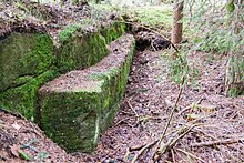
of the moist forest

with remains of the blasted

Bunker system from the


Web links
Individual evidence
- ↑ Location of the Lettensturz on Bavaria Atlas
- ↑ Lettensturz quarry on historical map
- ↑ "von dem Steine zu prechen" , master builder book of T. Endress from 1446-1475, pages 84-88
- ^ Flak ring around Nuremberg
Coordinates: 49 ° 23 '28.4 " N , 11 ° 13' 26.9" E