
Laufamholzer Forest

The Laufamholzer Forest is a municipality-free area in the central Franconian district of Nürnberger Land .
The 6.55 km² large state forest is the part of the Lorenzer Reichswald located south of the Nuremberg district of Laufamholz and the town of Schwaig . The A3 motorway forms the north-eastern border , the Nuremberg – Schwandorf railway line the north-western border. The deer head ( 49 ° 26 '57.3 " N , 11 ° 11' 59.89" O ) is 380 m above sea level. NN the highest point in the area. A large part is part of the EU bird sanctuary area Nuremberg Reichswald .
Waters
The area is crossed by the Schneidersbach in the north .
Geotope
In the southwest of the Laufamholzer Forest is the Schüsselstein ( 49 ° 26 ′ 18.13 ″ N , 11 ° 11 ′ 19.82 ″ E ), a large sandstone monolith in the sandstone Keuper region of the Central Franconian Basin . There are smaller caves and several bowl-like depressions in the rock. The name of the rock comes from its bowl-shaped depressions, which are partially filled with water after rain. The rock is designated as geotope 574R005 and a ground monument.
Monuments
Murder victim June 1, 1945
On the forest road from Schwaig (Oberer Röthelweg) to Brunn (Drei Hutbuchen) there is a memorial stone erected in 1982 ( 49 ° 27 ′ 1.36 ″ N , 11 ° 12 ′ 37.7 ″ E ), commemorating nine murder victims of the June 1, 1945 remembered. After the end of the Second World War, nine people between the ages of 6 and 63 were killed here at the so-called “Stone Bank”. The fate of the three men, the five women and the child remains unexplained even by an American daily report that is in the Nuremberg State Archives .
Forest district landmarks
In order to determine the condition of the devastated forests, forest management was carried out in the Nuremberg Reichswald in 1840/41 . In this context, such forest district boundary stones (district boundary pillars) were also created. They show the adjoining area on each side. It shows forest hammers . The foresters used it to mark every single tree to prevent wood theft.
Forest district boundary stone at the bowl stone
This forest district boundary stone is located west of the Schüsselstein directly on the forest road ( 49 ° 26 ′ 17.23 ″ N , 11 ° 11 ′ 13.88 ″ E ). Here Laufamholz, Brunn and Forsthof are demarcated. The triangular sandstone pillar with a niche top is designated by the Bavarian State Office for the Preservation of Monuments as an architectural monument (D-5-64-000-2245).
Forest district landmark Three hat beeches
North of Schwaig at the three Hutbuchen in a forest road junction ( 49 ° 26 '55.07 " N , 11 ° 12' 43.96" O ) is this Forstrevier landmark. Here Laufamholz, Brunn and Röthenbach are demarcated.
See also
- List of unincorporated areas in Bavaria
- List of ground monuments in the Laufamholz Forest
- List of geotopes in the district of Nürnberger Land
- List of rivers in the Pegnitz river system
- List of architectural monuments in unincorporated areas in Bavaria
Picture gallery
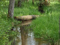
The Schneidersbach

The bowl stone

Memorial stone for the murder June 1, 1945
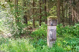
Forest district boundary stone at the bowl stone

Forest district landmark Three hat beeches


Individual evidence
- ↑ Area information at www.destatis.de, as of December 31, 2018 , accessed on August 1, 2020.
- ↑ www.protectedplanet.net, Nürnberger Reichswald (accessed on August 4, 2017)
- ↑ 6533-471 Nuremberg Reichswald. (EU bird sanctuary) Profiles of the Natura 2000 areas. Published by the Federal Agency for Nature Conservation . Retrieved November 27, 2017.
- ↑ Geotope: 574R005Schüsselstein (PDF file; 168 kB)
- ↑ Ground monument: D-5-6533-0125
- ^ Behringersdorf - Malmsbach - Schwaig . Pictures from the life of a community in the Nürnberger Land - then and now. Published by the Geschichts- und Kulturkreis Schwaig-Behringersdorf eV, ISBN 978-3-00-016895-6 , Schwaig, October 2005.
- ^ Bavarian State Forests, Monuments in the Nuremberg Reich Forest
Web links
- Area course Laufamholzer Forst in OpenStreetMap (accessed on June 2, 2015)
Coordinates: 49 ° 26 ′ 39 " N , 11 ° 11 ′ 47" E

Alfeld | Altdorf near Nuremberg | Burgthann | Engelthal | Damp | Happurg | Hartenstein | Henfenfeld | Hersbruck | Kirchensittenbach | Lauf an der Pegnitz | Leinburg | Neuhaus an der Pegnitz | Neunkirchen am Sand | Offenhausen | Ottensoos | Pommelsbrunn | Reichenschwand | Röthenbach an der Pegnitz | Rückersdorf | Schnaittach | Schwaig near Nuremberg | Schwarzenbruck | Simmelsdorf | Velden | Provision | Winkelhaid
Unregulated areas:
Behringersdorfer Forst |
Brunn |
Engelthaler Forest |
Moist forest |
Fischbach |
Forsthof |
Günthersbühler Forest |
Haimendorfer Forest |
Laufamholzer Forest |
Leinburg |
Rückersdorfer Forst |
Schoenberg |
Winkelhaid |
Zerzabelshofer Forest