
Simmelsdorf
| coat of arms | Germany map | |
|---|---|---|

|
Coordinates: 49 ° 36 ' N , 11 ° 20' E |
|
| Basic data | ||
| State : | Bavaria | |
| Administrative region : | Middle Franconia | |
| County : | Nuremberg country | |
| Height : | 375 m above sea level NHN | |
| Area : | 40.87 km 2 | |
| Residents: | 3328 (Dec. 31, 2019) | |
| Population density : | 81 inhabitants per km 2 | |
| Postal code : | 91245 | |
| Area code : | 09155 | |
| License plate : | LAU, ESB , HEB, N , PEG | |
| Community key : | 09 5 74 158 | |
| LOCODE : | DE S3F | |
| Community structure: | 24 parts of the community | |
| Address of the municipal administration: |
Nürnberger Str. 16 91245 Simmelsdorf |
|
| Website : | ||
| First Mayor : | Perry Gumann ( Free Electoral Community ) | |
| Location of the community Simmelsdorf in the district of Nürnberger Land | ||
 |
||

Simmelsdorf is a municipality in the central Franconian district of Nürnberger Land .
geography
Geographical location
The municipality is located in northern Bavaria , 30 kilometers northeast of Nuremberg and belongs to the Nuremberg Metropolitan Region . The core town of Simmelsdorf is located at the confluence of the Haunach and the eighth to the Schnaittach . The other localities are in the Schnaittachtal, on the Schnaittach and its tributaries. Several flour mills and wood sawmills were operated there, which are still electrified in operation or can be viewed as a museum.
Neighboring communities of Simmelsdorf are (starting in the north clockwise) Betzenstein , Schnaittach , Weißenohe , Graefenberg and Hiltpoltstein .
Community structure
The municipality has 24 officially named parts of the municipality (the type of place is given in brackets ):
|
|
|
There are also the places Ittlinger Mühle and Schindelrangen , both of which are not officially named parts of the municipality.
Ittlinger Mühle has belonged to Ittling since the 19th century. The place name of the hamlet of Schindelrangen was canceled on April 1, 1986, it is now part of Judenhof. The largest place in the municipality is Hüttenbach, which also has the best infrastructure (elementary school, food, banks), followed by Simmelsdorf with the seat of the municipal administration and the Simmelsdorf-Hüttenbach train station (see traffic ).
Geology and hydrology
Simmelsdorf and its districts are located in the Schnaittach Valley between Franconian Switzerland in the north-west and Hersbrucker Switzerland in the south-east, both of which belong to the Franconian Alb . Geologically, the Franconian Alb is a continuation of the Swiss Jura and the Swabian Alb . In the quarries, fossils can be found from 150 million years ago, when the area was still covered by the sea and the limestone cliffs were formed by sediments .
The area of the municipality of Simmelsdorf is the headwaters of the Schnaittach: from west to east the Haunach Valley, the Naifertal and the Achteltal. The waters have a good gradient and drive several mills.
The Naifer rises in a spring pot below St. Helena and forms the Naifertal with the villages of Obernaifermühle, Mittelaifermühe, Unterstaifermühle and Utzmannsbach. The Ittlinger Bach rises below Ittling and forms the Ittlinger Tal with the towns of Ittlinger Mühle, Oberachtel and Unterachtel. The Naifer and Ittlinger Bach form the Schnaittach above Diepoltsdorf. There is a larger fish farm there. The Haunach rises in a quarry north of Oberndorf, flows shortly thereafter through Oberndorf and drives a sawmill there. Then it flows through Hüttenbach with a former grain mill, the district of Simmelsdorf, where it used to water the moat of the Tucher Castle, and flows below it into the Schnaittach.
The Schnaittach flows through Diepoltsdorf and operates a hammer mill and a grain mill there. It used to also fill the moat. It then passes Simmelsdorf, where it operates a mill above the village, and takes up the Haunach below the village. After continuing through the Schnaittachtal, it flows east of the city of Lauf into the Pegnitz .
history
Simmelsdorf was first mentioned in 1195 as "Sumilidorf" and in 1329 as "Symleinsdorf", and in 1360 another mention followed. The landlords are named: 1350 Dietrich III. von Wildenstein and in 1352 an Ulrich Neighbor. The fortified seat was probably built during this time. In 1366 Emperor Charles IV bought the place. Since then (from 1368 to 1598) the Lords Türriegel von Riegelstein sat at the castle as royal Bohemian ministerials . In 1504 they sold one half of the manor , and in 1506 the other half to the Seckendorff , who were related to them , but in 1570 and 1572 they both had to sell their shares to Werner II. The half-timbering of the pond house, which sits on a limestone plinth, must have been completely renewed in 1445–55, as a dendrochronological analysis in 1990 showed.


Debts again forced Georg Michael Türriegel, who had received Simmelsdorf after an inheritance had been divided, in 1594 to enter into purchase negotiations with the Tucher patrician family from Nuremberg . Only after lengthy, sometimes violent disputes with the Rothenberg inheritance , which had even led to the imprisonment of the door bolt and the brief occupation of the castle, did the Nuremberg family manage in 1598 to purchase the Simmelsdorf manor for the Dr. Lorenz Tucher Foundation . The objection of the Electoral Palatinate , which claimed the feudal lordship over the Rothenberg, then delayed the Tucher taking possession again. Only the recognition of the Elector Friedrich IV of the Palatinate as sovereign and the obligation of the Tucher as Palatinate citizens cleared the way for the Tucher Foundation. In February 1607 the castle, which was meanwhile in need of considerable renovation, was handed over to the foundation administrators. Under the direction of Endres VI. Tucher (1551-1630) the seat was restored from 1607 on. Since then, the family, whose foundation still owns the Simmelsdorf castles, has been called Tucher von Simmelsdorf .
Around 1845/48 the old Weiherhaus , a residential tower-like main building in the middle of a Weiher-Graben complex, was changed. The trench was filled in and a landscape garden was created by the garden architect Eduard Petzold . The mansion was, allegedly based on designs by the former Nuremberg city building inspector Leonhard Schmidtner (1799–1873), provided with four striking corner turrets and a historicizing octagonal stair tower on the northwest side; the timbers for the corner turrets are said to come from the Rothenberg Fortress, which was abandoned in 1838 . The old Tucherschloss still serves as a meeting place for the family council and as a residence. In the park on the Haunach there is also the New Tucher Palace, built in 1844/45 in neo-Gothic style instead of a court clerk's house as an official and Voith house , also owned by the Tucher Foundation.
A former paint hammer became a paper mill in 1701 and a glass mill in 1861.
Incorporations
On July 1, 1931, the village of Au was incorporated into the previously independent municipality of Rabenshof . On July 1, 1971 Diepoltsdorf was added. On January 1, 1972, it was merged with the municipality of Hüttenbach. Großengsee followed on July 1, 1972, Oberndorf and Wildenfels were added on January 1, 1978.
On April 1, 1971, the Utzmannsbach community had already lost its independence and was incorporated into Diepoltsdorf.
Residents
In 2003, 3318 people lived in Simmelsdorf. In 2010, 3121 residents had their first place of residence in the municipality of Simmelsdorf, in 2012 there were 3140 and in 2016 3431 .:
| place | 2010 | 2012 | 2016 | 2020 |
|---|---|---|---|---|
| entire community | 3121 | 3140 | 3431 | 3464 |
| Huettenbach | 992 | 1010 | 1069 | 1030 |
| Simmelsdorf | 557 | 577 | 686 | 700 |
| Diepoltsdorf | 307 | 300 | 310 | 308 |
| Unterwindsberg | 204 | 200 | 293 | 326 |
| Großengsee | 203 | 195 | 203 | 209 |
| Ittling | 172 | 182 | 186 | 186 |
| Oberndorf | 165 | 160 | 157 | 159 |
| Winter stone | 108 | 106 | 108 | 123 |
| Wildenfels | 50 | 48 | 57 | 41 |
| St. Helena | 49 | 51 | 51 | 53 |
| Ray rock | 49 | 52 | 51 | 59 |
| Unterachtel | 39 | 34 | 22nd | 43 |
| Upper eighth | 37 | 36 | 38 | 33 |
| Oberwindsberg | 34 | 33 | 33 | 32 |
| Utzmannsbach | 34 | 33 | 33 | 37 |
| Rampertshof | 30th | 26th | 27 | 25th |
| Buhl | 19th | 19th | 20th | 24 |
| Clapboard | 17th | 25th | 30th | 30th |
| Judenhof | 16 | 14th | 11 | 12 |
| Ober-, Mittel-, Unterstaifermühle | 14th | 14th | 15th | 14th |
| Au | 13 | 14th | 18th | 17th |
| Ittlinger mill | 8th | 8th | 9 | 9 |
| Kaltenhof | 2 | 2 | 2 | 2 |
| St. Martin | 1 | 1 | 2 | 2 |
politics
mayor
| from | to | mayor |
|---|---|---|
| 2008 | Perry Gumann (FWG) | |
| 1988 | 2008 | Andreas Kögel (CSU) |
| 1988 | Ria Vogler |
In the local elections on March 15, 2020, Perry Gumann was re-elected with 79.58% of the vote.
Municipal council
The municipal council of Simmelsdorf consists of 16 councilors and the first mayor.
| CSU | FWG | the INDEPENDENTS | FDP | Green | |
| 1996 | 6th | 4th | 4th | 1 | 1 |
| 2002 | 6th | 5 | 5 | ||
| 2008 | 6th | 5 | 5 | ||
| 2014 | 6th | 6th | 4th | ||
| 2020 | 4th | 6th | 6th |
(Status: local election on March 15, 2020) In the local election on March 15, 2020, 1,788 of the 2,768 residents in the municipality of Simmelsdorf exercised their right to vote, bringing the voter turnout to 64.60%.
Town twinning
-
 The small town of Scheibenberg in the Ore Mountains ( Saxony )
Culture and sights
Buildings
- The Tucher mausoleum is located between Simmelsdorf and Hüttenbach
- The valley bridge Schnaittach , with a length of 1288 m, the second longest motorway bridge in Bavaria, forms an optical border to the community of Schnaittach south of Simmelsdorf in the Schnaittach Valley .
Palaces and castles
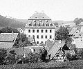
- The old Tucherschloss in Simmelsdorf is worth seeing. This old moated castle, rebuilt in Gothic style by Leonhard Schmidtner in 1830–41 , is still the ancestral seat of the von Tucher family .
- Hüttenbach Castle, a baroque castle from the 16th century in the center of Hüttenbach
- The Wildenfels castle ruins are located in Wildenfels .
- the Postal Hienberg are only remnants exist.

Front dwelling Diepoltsdorf
Hüttenbach Castle
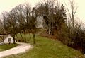
Wildenfels castle ruins

Burgstall Hienberg


Churches

- Baroque Church of the Visitation of the Virgin Mary, Bühl . The Catholic parish church is located on a mountain spur above Simmelsdorf. It was first mentioned in 1227. Today's baroque church dates from 1472.
theatre
- Simmelsdorfer Mühle-Theater (formerly a bicycle mill , a national bicycle dealer), later an event location with changing organization, today a private residence.
Economy and Infrastructure
Established businesses
- Several limestone quarries
- Several mills and sawmills
The company Albflor-Milchwerke, located since 1908, subsidiary of the Naabtaler Milchwerke since 1994 , has been closed since 2012. In 2015 the site was completely cleared.
The large equestrian facility in Simmelsdorf, formerly “Hobby Horse”, was closed in 2018.
traffic
Rail transport
The Simmelsdorf-Hüttenbach station is the terminus of the Neunkirchen an Sand – Simmelsdorf-Hüttenbach railway . The train runs through the city of Lauf an der Pegnitz (district) directly to Nuremberg . From the branching station Neunkirchen am Sand there are connections to Hersbruck and Prague .
The Simmelsdorf districts can be reached from the Simmelsdorf train station with two bus routes.
Private transport
The A 9 Nuremberg – Berlin motorway touches the municipality in the south-east, the town of Simmelsdorf is three kilometers from the Schnaittach exit (AS 48). On the Hienberg, shortly after the Schnaittach valley bridge , the A 9 is divided into a north-east and a south-west lane; Because of the gradient, this section is regularly mentioned in the traffic jam reports in winter.
Hiking trails
The Franconian Marienweg runs through Simmelsdorf .
Shopping
There are three butchers in Hüttenbach. There are no other shops in the community. There are only other grocery stores in Schnaittach, three kilometers away.
Medical supplies
There is a veterinarian in Unterwindsberg and a dentist in Hüttenbach. The long-standing country doctor's practice in Tucher Castle was closed in 2018.
Restaurants
The Landgasthof Lang at Simmelsdorf train station was closed in 2016 as the last witness to a previously flourishing pub and tourism culture. Only the Daut butcher in Hüttenbach offers a lunch menu in the former inn on Sundays. The Zum Fichtenpark restaurant is located in Unteraifermühle, the Zu den Linden restaurant in Utzmannsbach and the Scharrer Inn in Winterstein.
Personalities
- Lorenz Horn (* 1880 in Gärtenroth near Kulmbach, † 1956 in Hüttenbach), Sergeant of the Ksl. State Police of German South West Africa / NCO of the cavalry
literature
- Johann Kaspar Bundschuh : Simmelsdorf . In: Geographical Statistical-Topographical Lexicon of Franconia . tape 5 : S-U . Verlag der Stettinische Buchhandlung, Ulm 1802, DNB 790364328 , OCLC 833753112 , Sp. 338-339 ( digitized version ).
Web links
- Simmelsdorf community
- Entry on the coat of arms of Simmelsdorf in the database of the House of Bavarian History
Individual evidence
- ↑ "Data 2" sheet, Statistical Report A1200C 202041 Population of the municipalities, districts and administrative districts 1st quarter 2020 (population based on the 2011 census) ( help ).
- ^ Community Simmelsdorf in the local database of the Bavarian State Library Online . Bayerische Staatsbibliothek, accessed on December 25, 2019.
- ↑ Herrensitze.com (Giersch / Schlunk / von Haller)
- ↑ Herrensitze.com, History of Simmelsdorf
- ↑ Das Nürnberger Land , August 31, 2018
- ↑ a b Wilhelm Volkert (Ed.): Handbook of the Bavarian offices, communities and courts 1799–1980 . CH Beck, Munich 1983, ISBN 3-406-09669-7 , p. 509 f .
- ^ Federal Statistical Office (ed.): Historical municipality directory for the Federal Republic of Germany. Name, border and key number changes in municipalities, counties and administrative districts from May 27, 1970 to December 31, 1982 . W. Kohlhammer, Stuttgart / Mainz 1983, ISBN 3-17-003263-1 , p. 719 .
- ^ Pegnitzzeitung, as of June 30, 2003
- ↑ Population figures in Simmelsdorf
- ↑ Results of local elections 2020. OK.VOTE, March 15, 2020, accessed on May 18, 2020 .
- ↑ Results of local elections 2020. OK.VOTE, March 15, 2020, accessed on May 18, 2020 .
- ↑ Results of local elections 2020. OK.VOTE, March 15, 2020, accessed on May 18, 2020 .
- ^ Herrensitze.com , History of Schloss Hüttenbach
- ↑ history. Privatmolkerei Bechtel, accessed on November 13, 2017 .
- ↑ Excavators razed the former "Albflor-Milchwerke" to the ground. In: Pegnitz newspaper . n-land.de, June 30, 2015, accessed on November 13, 2017 .
- ↑ The traditional inn "Lang" closes after 120 years

Alfeld | Altdorf near Nuremberg | Burgthann | Engelthal | Damp | Happurg | Hartenstein | Henfenfeld | Hersbruck | Kirchensittenbach | Lauf an der Pegnitz | Leinburg | Neuhaus an der Pegnitz | Neunkirchen am Sand | Offenhausen | Ottensoos | Pommelsbrunn | Reichenschwand | Röthenbach an der Pegnitz | Rückersdorf | Schnaittach | Schwaig near Nuremberg | Schwarzenbruck | Simmelsdorf | Velden | Provision | Winkelhaid
Unregulated areas:
Behringersdorfer Forst |
Brunn |
Engelthaler Forest |
Moist forest |
Fischbach |
Forsthof |
Günthersbühler Forest |
Haimendorfer Forest |
Laufamholzer Forest |
Leinburg |
Rückersdorfer Forst |
Schoenberg |
Winkelhaid |
Zerzabelshofer Forest
Au | Bühl | Diepoltsdorf | Großengsee | Hüttenbach | Ittling | Ittlinger Mill | Judenhof | Kaltenhof | Middle Aifer Mill | Oberachtel | Obernaifermühle | Oberndorf | Oberwindsberg | Rampertshof | Saint Helena | Saint Martin | Simmelsdorf | Shingle ranges | Radiant Rock | Subcute | Unteraifermühle | Unterwindsberg | Utzmannsbach | Wildenfels | Winter stone