Bühl (Simmelsdorf)
|
Buhl
Community Simmelsdorf
Coordinates: 49 ° 36 ′ 11 ″ N , 11 ° 20 ′ 24 ″ E
|
|
|---|---|
| Height : | 440 m above sea level NHN |
| Residents : | 20 (2016) |
| Postal code : | 91245 |
| Area code : | 09155 |
|
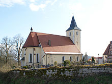
The church of the Simmelsdorf district of Bühl
|
|
Bühl is one of 24 districts in the municipality of Simmelsdorf in Middle Franconia .
geography
The parish village is located about 800 meters north-northeast of the center of Simmelsdorf on a mountain spur ( 440 m above sea level ) between the upper Schnaittach valley and the Haunach valley. It essentially consists of the church with a cemetery, a large manorial rectory and a residential community (former restaurant for excursions).
history
Bühl was probably created in the 8th century as a mission parish of the Eichstätt diocese . The first mention was made in 1237 on the occasion of a legal dispute between its pastor and the provost of Bamberg.
By the administrative reforms at the beginning of the 19th century in the Kingdom of Bavaria the place was with the Second Gemeindeedikt part of the rural community Hüttenbach , which includes the remote area Kaltenhof belonged. The municipality was incorporated into the municipality of Simmelsdorf as part of the municipal regional reform in Bavaria in 1972. In 2016 Bühl had 20 residents.
traffic
Local roads lead to Hüttenbach, Simmelsdorf and Diepoltsdorf .
Bühl is the starting point for many hiking routes in Franconian Switzerland , a five-minute walk from the Simmelsdorf train station . The Franconian Marienweg runs through the village .
Baroque Church of the Visitation of the Virgin Mary
The Catholic parish church in Bühl is easily recognizable from afar (illuminated at night). It stands on the high mountain spur that protrudes far into the Schnaittach Valley directly above Simmelsdorf. The area was evangelized as early as the turn of the millennium, the first mentioning was in 1227. Today's Bühler church with fortified mountain cemetery dates from 1472. The Gothic choir also dates back to this time, the pointed tower dates from 1558. 1714 to 1755 that was Baroque style building . Johann Michael Doser made the pulpit and the baroque altar with five life-size figures, with Maria in the center with a halo. The left side altar is dedicated to St. Wolfgang, the right to St. John. The grave inscriptions of the noble Lochner von Hüttenbach family and the tomb of Hans Türriegel from 1551 are worth mentioning. The bishop awarded Bühl with extensive land holdings as benefices to the Bamberg canons .
The church and the rectory are architectural monuments, see the list of architectural monuments in Bühl
literature
- Nuremberg country . Karl Pfeiffer's Buchdruckerei und Verlag, Hersbruck 1993. ISBN 3-9800386-5-3
Web links
- Bühl on the community website
- Bühl in the BayernAtlas (accessed on October 13, 2017)
- Bühl on a historical map (accessed on October 13, 2017)
Individual evidence
- ↑ Population of Bühl on the website of the municipality of Simmelsdorf (accessed on October 13, 2017)
- ↑ Bühl in the location database of the Bayerische Landesbibliothek Online (accessed on October 13, 2017)
- ↑ Brief description of Bühl on the website of the municipality of Simmelsdorf (accessed on October 13, 2017)
- ↑ Political composition of the rural community of Hüttenbach (accessed on October 13, 2017)
- ^ Federal Statistical Office (ed.): Historical municipality directory for the Federal Republic of Germany. Name, border and key number changes in municipalities, counties and administrative districts from May 27, 1970 to December 31, 1982 . W. Kohlhammer, Stuttgart / Mainz 1983, ISBN 3-17-003263-1 , p. 718 .


