Unterachtel (Simmelsdorf)
|
Unterachtel
Community Simmelsdorf
Coordinates: 49 ° 36 ′ 56 ″ N , 11 ° 22 ′ 12 ″ E
|
|
|---|---|
| Height : | 415 m above sea level NHN |
| Residents : | 22 (Dec. 31, 2016) |
| Postal code : | 91245 |
| Area code : | 09155 |
|
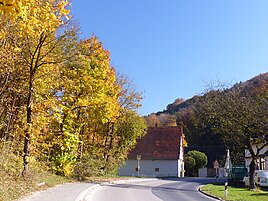
The Unterachtel district of Simmelsdorf
|
|
Unterachtel is a district of the Central Franconian community of Simmelsdorf in the district of Nürnberger Land .
geography
The hamlet is located in the Achteltal on the Ittlinger Bach , just under 3 km northeast of Simmelsdorf.
history
Ober- and Unterachtel are first mentioned in 1390 in the forest code of the Auerbach regional court .
Due to the administrative reforms carried out in the Kingdom of Bavaria at the beginning of the 19th century , Unterachtel became a district of the Utzmannsbach rural community with the second municipal edict . On April 1, 1971, the municipality was incorporated into the municipality of Diepoltsdorf in the course of the municipal area reform and this in turn was incorporated into Simmelsdorf on July 1, 1971.
Facilities
At the southern end of the village there is a retirement home, the former Kurhaus Kraft, since 2014 accommodation for asylum seekers.
A former mill is mentioned as a monument. → List of architectural monuments in Unterachtel

