Betzenstein
| coat of arms | Germany map | |
|---|---|---|

|
Coordinates: 49 ° 41 ′ N , 11 ° 25 ′ E |
|
| Basic data | ||
| State : | Bavaria | |
| Administrative region : | Upper Franconia | |
| County : | Bayreuth | |
| Management Community : | Betzenstein | |
| Height : | 511 m above sea level NHN | |
| Area : | 51.85 km 2 | |
| Residents: | 2443 (Dec. 31, 2019) | |
| Population density : | 47 inhabitants per km 2 | |
| Postal code : | 91282 | |
| Area code : | 09244 | |
| License plate : | BT, EBS , ESB , KEM , MÜB , PEG | |
| Community key : | 09 4 72 118 | |
| LOCODE : | DE 8BC | |
| City structure: | 23 parts of the community | |
City administration address : |
Nürnberger Strasse 5 91282 Betzenstein |
|
| Website : | ||
| First Mayor : | Claus Meyer ( Free Voters ) | |
| Location of the city of Betzenstein in the Bayreuth district | ||
Betzenstein is a town in the Upper Franconian district of Bayreuth and the seat of the Betzenstein administrative community .
geography
The place is in the Franconian Switzerland Nature Park on the northwestern edge of the Hersbrucker Alb at the transition to Franconian Switzerland .
Neighboring communities
Neighboring communities are, starting from the north, clockwise: Pegnitz , Plech , Velden , Kirchensittenbach , Schnaittach , Simmelsdorf , Hiltpoltstein , Obertrubach and Pottenstein .
Community structure
There are 23 officially named parts of the municipality (the type of place is given in brackets ):
|
|
|
There are also the residential areas Hersbrucker Hütte , Laufer Hütte , Reuthof and Windmühle .
Administrative community
The city forms an administrative community with the municipality of Plech .
history
Betzenstein was first mentioned in 1187 with Friedrich von Betzenstein . In 1359, Emperor Charles IV granted market and town rights. From 1505 until its incorporation into Bavaria in 1806, Betzenstein belonged to the area of the imperial city of Nuremberg , which from 1500 belonged to the Franconian Empire .
On August 7, 1806, the Betzenstein nursing office was dissolved and the place was subordinated to the Pottenstein district court .
Hops were grown in the area until the 20th century . The Barth family, leading on the world hop market, has its roots in Betzenstein. The main building with its typical hop kilns in the steep gable roof is still on the market square. Iron ore mining was also of great importance until the end of the 19th century.
Incorporations
On January 1, 1972, the previously independent communities of Leupoldstein, Ottenberg, Spies, Stierberg and Weidensees were incorporated.
Population development
In the period from 1988 to 2018, the city grew from 2,257 to 2,475 by 218 inhabitants or 9.7%. A peak was reached on December 31, 2004 with 2598 inhabitants.
politics
mayor
Mayor is Claus Meyer (Free Voters).
City council
Since the last local election on March 15, 2020, the city council has 14 members. The turnout was 68.27%. The choice brought the following result:
| CSU | 4 seats | (27.38%) | |
| Community of voters | 3 seats | (20.88%) | |
| Free voters | 4 seats | (33.13%) | |
| Independent citizens | 3 seats | (18.61%) |
Another member and chairman of the city council is the mayor.
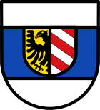
coat of arms
|
Blazon : “A blue bar in silver covered with a split shield; in the front in gold half a red-tongued black eagle at the slit, at the back divided diagonally five times by red and silver. "
Citations |
|
| Foundation of the coat of arms: In 1359, Emperor Karl IV granted the Landgraves of Leuchtenberg high jurisdiction for Betzenstein as well as town and market rights. From the year 1395 there is a seal in the print with the inscription S. VNIVERSITATIS CIVIVM DE PECZENSTEIN and the coat of arms of the Landgraves of Leuchtenberg, a blue bar in silver. The landgraves were then the local lords of Betzenstein. In 1418 they sold the castle and the market to the Wittelsbach family. In 1504 the imperial city of Nuremberg acquired local rule and set up a nursing office there. During this time she also changed the coat of arms. The blue bar was covered with the split shield of the imperial city. Up until the transition from Nuremberg to Bavaria in 1806, Nuremberg held local authority and sovereignty in Betzenstein. In 1819 the eagle had to be tinged red and the rear half of the shield in the Bavarian national colors silver and blue. The red eagle has since been misinterpreted as the Brandenburg eagle. |
Culture and sights
museum
Until 2010 there was the Anton Buchner Heimatmuseum with historical evidence as well as fossil and mineralogical collections.
A part of this historical and mineralogical collection is exhibited today in the Betzenstein tourist information.
Buildings
- Evangelical parish church, built 1732–1748
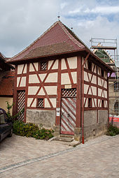
- Deep well in a half-timbered house on the lower market square, 92 meters deep, built in 1543–1549 as a wheel-pulling well, served as a water supply for centuries
- Monument to Abraham Wolfgang Küfner in front of the Lower Gate
- Parts of the former city wall with two city gates (rear gate and lower gate)
- Former Nursing Office Castle, built 1669–1670 (privately owned)
- Doppelburg (privately owned, not accessible)
- Schmidberg facility with a 12 meter high Schmidbergturm observation tower
nature
- The Juraelefant near Stierberg, a limestone rock with an elephant-like appearance.
- The Klauskirche , a thirty-meter-long through cave at the Betzenstein outdoor pool (geotope number 472H004).
- The Great Water Stone , a natural monument with a through cave (water stone gate) and a large rock overhang
- Rock arch and cave system in the reef south of Leupoldstein
- The Hexentor , a rock gate and natural monument
Sports
The city is located in the middle of the Northern Franconian Jura climbing area , and numerous hiking and cycling trails lead through the city. In Betzenstein there is a heated outdoor pool and the Betzenstein Adventure Park with a children's climbing world is adjacent. In winter, depending on the weather, a network of trails is groomed south of the city.
The FC Betzenstein offers as sports u. a. Football, tennis and table tennis.
Transport links
Betzenstein is on the federal highway 2 between Nuremberg and Bayreuth. The place can also be reached via the A 9 , junction Plech. The closest railway line is the Nuremberg – Cheb line with the Neuhaus a. d. Peg. or Pegnitz. Betzenstein is in the tariff range of the VGN .
literature
- Johann Kaspar Bundschuh : Bezenstein . In: Geographical Statistical-Topographical Lexicon of Franconia . tape 1 : A-egg . Verlag der Stettinische Buchhandlung, Ulm 1799, DNB 790364298 , OCLC 833753073 , Sp. 373-375 ( digitized version ).
- Chronicle of the city of Betzenstein. Published for the 800th anniversary in 1987, Stadt Betzenstein.
- Josef Pfanner: District of Pegnitz . In: Historical book of place names of Bavaria . Commission for Bavarian State History, Munich 1965, ISBN 3-7696-9864-9 .
- Pleikard Joseph Stumpf : Petzenstein . In: Bavaria: a geographical-statistical-historical handbook of the kingdom; for the Bavarian people . Second part. Munich 1853, p. 624 ( digitized version ).
- Hans Vollet and Kathrin Heckel: The ruins drawings by the Plassenburg cartographer Johann Christoph Stierlein . 1987.
- Federal Statistical Office (Hrsg.): Historical municipality register for the Federal Republic of Germany. Name, border and key number changes in municipalities, counties and administrative districts from May 27, 1970 to December 31, 1982 . W. Kohlhammer, Stuttgart / Mainz 1983, ISBN 3-17-003263-1 .
Web links
Individual evidence
- ↑ "Data 2" sheet, Statistical Report A1200C 202041 Population of the municipalities, districts and administrative districts 1st quarter 2020 (population based on the 2011 census) ( help ).
- ↑ Mayor, City Council, Committees. City administration Betzenstein, accessed on May 30, 2020 .
- ^ Betzenstein community in the local database of the Bavarian State Library Online . Bayerische Staatsbibliothek, accessed on January 5, 2020.
- ↑ See also: List of Frankish knight families # B
- ^ History of the city of Betzenstein. Sections “25. September 1359 "and" 1611 ".
- ^ Armin Schütz: Betzenstein on the side of the imperial city of Nuremberg . 2011, p. 75
- ^ Wilhelm Volkert (ed.): Handbook of Bavarian offices, communities and courts 1799–1980 . CH Beck, Munich 1983, ISBN 3-406-09669-7 , p. 549 .
- ↑ Entry on the coat of arms of Betzenstein in the database of the House of Bavarian History
- ^ Posts: Dear guests. Betzenstein, September 28, 2016, accessed November 26, 2016 .
- ↑ Schmiedbergturm Betzenstein. In: fraenkische-schweiz.bayern-online.de. November 19, 2008, accessed on September 18, 2015 (note: correct spelling of the Schmidbergturm ).


