Johann Christoph Stierlein
Johann Christoph Stierlein (born April 11, 1759 , † July 2, 1827 ) was, among other things, Royal Prussian Engineer Capitaine in his military career and particularly excelled as a cartographer in the Fichtelgebirge area . His first-time and precise measurements and the drawings of local castles made in this context are an important source of information for castle research today.
Origin and family
Johann Christoph Stierlein was the son of the pastor Johann Immanuel Stierlein (1720–1759), his mother was the daughter of the cartographer Johann Georg Vetter (1681–1745). On March 12, 1787, he married Maria Friederike Hoffmann, the daughter of his superior, Major Johann Friedrich Carl Hoffmann (1733–1793). The three daughters Eleonora Carolina, Louise Charlotte and Friederike emerged from the marriage.
Military career
Johann Christoph Stierlein embarked on a military career. He began as an artillery cadet in the Principality of Ansbach , where he was accommodated as part of his training at the Plassenburg in Kulmbach , where he also found his place of work. The last Margrave of Brandenburg-Bayreuth and Brandenburg-Ansbach Christian Friedrich Karl Alexander sold his property to the relatives of the Prussian Hohenzollerns in a secret treaty . Johann Christoph switched to Prussian services and witnessed the beginning of the war between Prussia and Austria, when French prisoners of war were housed in Kulmbach and on the Plassenburg right at the beginning of the war. An epidemic led to the death of his superior and father-in-law Major Hoffmann. Johann Christoph continued his work, mainly the production of precise maps of the region. Among his employees was also the future General Field Marshal Wilhelm von Krauseneck . With the defeat of Prussia , the Plassenburg was occupied by Napoleon and the former principality eventually became part of Bavaria. After negotiations, Johann Christoph got a job as a second director in the Statistical-Topographical Bureau in Munich. He retired in 1826 and died a year later.
Today's map inventory is distributed across various archives. Because the Principality of Bayreuth came to Prussia, the military map from 1799, along with partial maps and brouillons, is part of the “Prussian Cultural Heritage” and is located in Berlin , apart from a smaller collection in the Bamberg State Archives . Other cards were part of the negotiations when Stierlein was taken over into the Bavarian state service; they are part of the collection of the Bavarian State Library in Munich . Cards about the brief occupation by Napoleon with Baron Camille de Tournon as general manager (administrative director) of the province of Bayreuth reached the archives of Vincennes near Paris .
Topographic castle maps
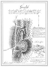
For castle research, etc. a. In the Sechsämterland in the transition to the Fichtelgebirge , Johann Christoph Stierlein is an essential source of information, as he was the first to carry out careful measurements and prepare inventory descriptions. In 37 sheets he recorded the ruins of castles, churches and chapels that are kept in the Bavarian State Library in Munich . He was a contemporary of the Hof high school director Johann Theodor Benjamin Helfrecht , who also expertly hiked and explored castles. The motives for research at this time were related to romanticism (see also: romanticization ). Stierlein’s records date from the period from 1782 to 1792 and were cleared by him in 1816.
The following structures were examined by him:
- Lichtenberg
- Thierbach Castle near Bad Steben
- Burgstein near Geroldsgrün
- Hohe Ruh Castle near Geroldsgrün
- Uprode
- Stockenroth
- Hallerstein
- Waldstein
- Katharinenberg near Wunsiedel
- Neuhaus
- Castle Foerles-Neudürrlas in Thierstein
- Thierstein
- Epprechtstein
- Rudolfstein
- Luisenburg
- Hirschstein
- Veste Mittelberg near Marktrodach
- Castles and churches of Wirsberg
- Hohenberneck Castle and Old Castle of Berneck
- stone
- Greenstone
- Ruin on Pfeiffersberg near Warmensteinach
- Burgstall Castle Hill near Weidenberg
- Weidenberg Castle
- Ruins on the Rauhen Kulm , in the center the Rauhenkulm castle stable , but also the Rauher Kulm ramparts
- Streitberg Castle
- Thuisbrunn Castle
- St. Jobst Monastery
- Castle ruin of Frankenberg near Speichersdorf
- Ruins of Altenkünsberg Castle near Creußen
- Ruins of Gottsfeld Castle near Creußen
- Traces of the Alten Creußen Castle
- Traces of a castle stable near Prebitz
- Boheimstein ruins near Pegnitz
- Riegelstein castle ruins
- Spies ruins near Betzenstein
- Osterohe castle ruins .
Works
- Johann Friedrich Carl Hofmann and Johann Christoph Stierlein: Military card from the CastenAmt GEFREES, then the VogteyAmter BERNECK, GOLDCRONACH and StAMBACH. ( Digitized version )
Topographic castle maps
- Drawing of Thierstein Castle (12) on the municipality's website
- Drawing of Epprechtstein Castle (13) at the HdBG
literature
- Hans Vollet: Outline of the cartography of the Principality of Kulmbach-Bayreuth . In: Die Plassenburg - Writings for home research and culture care , Volume 38. Kulmbach 1977. P. 133–151.
- Hans Vollet, Kathrin Heckel: The ruins drawings of the Plassenburg cartographer Johann Christoph Stierlein. The drawings from the collections of the Bavarian State Library in Munich. (Catalog for the exhibition of the Obermain Landscape Museum on the Plassenburg ob Kulmbach from March 25 to April 24, 1987), Kulmbach 1987.
Web links
- Biography at Who is who in Bayreuth?
- Works by and about Johann Christoph Stierlein in the German Digital Library
Individual evidence
- ↑ evolution of the city Neustadt to 1933. Ph. CW Schmidt, Neustadt ad Aisch 1950, pp 378-382.
- ↑ Vollet, Abriß der Kartographie, pp. 144–146.
| personal data | |
|---|---|
| SURNAME | Little Bull, Johann Christoph |
| BRIEF DESCRIPTION | German cartographer |
| DATE OF BIRTH | April 11, 1759 |
| DATE OF DEATH | July 2, 1827 |
