
Riegelstein castle ruins
| Riegelstein castle ruins | ||
|---|---|---|
 Image 1, The rocky reef on which the buildings of the upper castle stood, from the northeast |
||
| Creation time : | around 1200 | |
| Castle type : | Höhenburg, ridge position | |
| Conservation status: | Ruins that have not yet been restored, of which only very little building fabric has been preserved and which is also threatened with complete demolition | |
| Standing position : | Ministeriale | |
| Construction: | Quarry stone masonry | |
| Place: | Latch block | |
| Geographical location | 49 ° 38 '11.1 " N , 11 ° 25' 24.9" E | |
| Height: | 589 m above sea level NHN | |
|
||

The castle ruin Riegelstein is a former high medieval aristocratic castle north of the church village Riegelstein, which belongs to the town of Betzenstein, in the Upper Franconian district of Bayreuth in Bavaria , Germany . Only two trenches and a few unsecured remains of the wall remain of the abandoned Kammburg , which are threatened with complete removal.
Geographical location
The castle ruin is located in southeastern Franconian Switzerland , part of the Franconian Alb , on the highest point of the Riegelsteiner Schlossberg at 589 m above sea level. Above sea level. The ruin is located about 360 meters north-northeast of the Evangelical Lutheran branch church Sankt Georg in Riegelstein, the former Raupersdorf and about 32 kilometers northeast of Nuremberg .
You can reach it from the village of Riegelstein by following the footpath that runs along the west of the federal highway 9 . At the highest point of the path, shortly after the village, you have to continue up the mountain without a path. At the top you come across a bad forest path which, going north, ends at the neck of the castle. To get to the upper castle you have to climb the rocky reef.
There are other former medieval castles nearby; An unknown castle stable is located on the immediately neighboring Schweinsberg ; the former castles of Spies , Strahlfels and Wildenfels are located in a westerly and northwestern direction . The so-called Burgstall in Eibental is located 1.4 kilometers to the north, 550 meters high , and another completely unknown Burgstall on the Hühnerstein, three kilometers away, in a north-westerly direction
In 1792, Johann Christoph Stierlein made a true-to-scale topographical map of the castle ruins and their immediate surroundings. Different wall courses and a well or a cistern are clearly visible .
History of the castle


When the castle was built is not exactly known, but according to the Nuremberg castle researcher Hellmut Kunstmann , it could have been around the year 1200 based on ceramic finds he dated. It is also not known who built the castle. The belonging to the low nobility lords of door latches are probably not to be regarded as a castle founder, they sat as inferior servants of the taverns of Reicheneck on smaller mansions in Hammerbachtal at Engelthal . According to Gustav Voit, however, Riegelstein Castle was not built by the Türrigel family until 1360.
The first documentary mention of the Lords of Türriegel took place with Heinricus Türrigl shortly before 1260, when he was a witness for Walter Schenk von Klingenburg. The Klingenburgers were the masters of Reicheneck Castle at the time . The door bolts were also mentioned several times later, they were in Eschenbach and Simmelsdorf.
Riegelstein Castle itself was first mentioned in a document around 1403, when it was the seat of the brothers Hans, Georg, Dietrich and Heinz Türriegel. The ministerial family von Türrigel built or acquired the castle and made it their ancestral seat; from then on they called themselves "zum Riegelstein". Even the nearby Raupersdorf was named after the Riegelstein Castle.
On 15 February 1502 contributed Hans and Konz deadbolt their hitherto freely own castle to two-thirds the Margrave Friedrich II. From the Principality of Bayreuth to feud on, they also granted the Margrave and the opening right one, so he was allowed to use the castle in case of war. On June 16, 1502, Heinz Türriegel also gave the last third to the margrave as a fief. After the Riegelstein family died out with the death of Georg Michael Türriegel von Riegelstein on March 24, 1619, the margrave moved in the castle and the other feudal estates and enfeoffed the margrave chamberlain Henning von Wilmersdorf with it. After his death in 1637, Maria Elisabeth von Wilmersdorf, the widow of the chamberlain, prevented the castle from being confiscated by the margraves.
In the Thirty Years' War , the castle was occupied by Bavarian troops after 1642 and completely demolished. The widow's new husband, Christoph Adam von Varell zu Burghaig , was given the uninhabitable ruin in 1648/49 as a fief, but in 1712 applied for the sale of the castle, which in 1691 had already been described as a castle "... very desolate and desolate ...". Even then, the castle served as a quarry. In 1714 Riegelstein was sold to Christoph Ludwig Lochner von Hüttenbach after sales negotiations with Christoph Gottlieb Volckamer von Kirchensittenbach had failed. The barons of Harsdorf bought the manor in 1870; From the castle it was said in 1794: "... the whole Riegelstein castle, so dermally desolate and dilapidated, perhaps demolished, which still show some rudera [remains of ruins], lies in the middle of the forest, which is currently still called the Schloßberg ..."
Today the area of Castle Riegelstein is densely covered with forest, the castle rock serves as a climbing rock . Only the neck ditch, a section ditch and some remains of the foundation wall as well as the brickwork that has not risen much have survived. The ruin of the hilltop castle on the ridge is freely accessible.
The ground monument registered by the Bavarian State Office for the Preservation of Monuments as a "medieval castle stable" bears the monument number D-4-6334-0009.
Description of the castle ruins
The Riegelsteiner Schlossberg, a wooded mountain ridge interspersed with rocks, stretches from the southwest to the northeast. It drops off moderately steeply on all sides. About 100 meters from the north-eastern end of the mountain there is a rock reef with an area of about 25 × 10 and a height of 5 to 15 meters, on which the upper castle was located (Fig. 1). At the foot of the rocky reef, in a south-westerly direction, was the lower castle.
The ridge is divided by a neck ditch at a point about 30 meters wide (Fig. 2). This is a ditch 50 meters long, 4 meters wide and 8 meters deep carved into the rock. It ends on both sides on the steep slope. At its eastern end you can see a mound of debris, a sign of the artificial origin of the trench. The Burgweg (picture 3) came from the south-westerly direction from the village of Riegelstein, and ends in front of the neck ditch in a larger forecourt.
A rock rib was left at the edge of the neck ditch on the castle side, after which there is a second ditch at a distance of about two meters from the neck ditch, which is thirty meters long, ten meters wide and one meter deep (Fig. 4). Its bottom is seven meters higher than that of the neck ditch and runs in a semicircle around the lower castle. The second trench also served as a kennel .
The access to the castle was probably on a bridge over the neck ditch, then over the second ditch over a drawbridge to a gate tower (Fig. 5) of the lower castle. The left rock rib served as a support for the drawbridge.
The castle complex with the upper and lower castle is almost circular. The ground plan is divided into two semicircular areas from north to south, of which the lower castle represents the western area and the rock reef with the upper castle the eastern area. The lower castle plateau (Fig. 6) is four and a half meters above the bottom of the second trench. One can see longer remains of the foundation wall of the approx. Two meter thick curtain wall (Fig. 7), which ran in a semicircle around the lower castle. In the north and south, the wall hit the rocky reef that closed off the lower castle to the east. A gate tower, which, flanking the curtain wall, protruded a few meters, was located in the south of the lower castle. The foundation walls of it are still visible. In the area of the gate tower you can still see fragments of roof tiles and remains of mortar. Also in the south, between the gate tower and the rocky reef, was a building with an irregular triangular floor plan, as the remains of the foundation wall show. In the north of the lower castle was a round cistern with a diameter of one meter. Today's depth is 1.5 meters (Fig. 8). In the far west of the lower castle and immediately south of the cistern, there was a building about 15 × 8 meters in size, of which only a depression is visible (Fig. 9). Its western outer wall was also the curtain wall. In the center of the lower castle was probably the courtyard.
The rock reef on which the upper castle stood rises ten meters vertically above the lower castle (Figs. 10, 11 and 13). It drops vertically by about 15 meters on the north, east and south sides. How the ascent was earlier is uncertain, perhaps through wooden stairs in a notch in the rock (Fig. 11). There were several buildings on the rocky reef (Fig. 12) that formed the north-eastern end of the castle.
The castle was completely protected from this side by the vertical drop of the rocks. On the eastern edge of the plateau, several small remains of the wall can still be seen from below.
At the eastern foot of the rocky reef there is a small cave (Fig. 1, roughly in the middle of the rock, covered by undergrowth), which was closed off with a wall. The castle researcher Hellmut Kunstmann suspects that the cave, which is 15 meters below the upper castle and was outside the castle, was connected to the upper castle by an escape route.

Photo 2: Profile of the neck trench up to 8 meters deep

Photo 3: View of the Burgweg from the castle
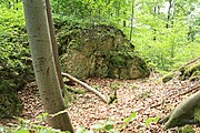
Photo 4: The second ditch and the rock ridge that probably served as a bridge pillar

Photo 5: The place of the gate tower

Image 6: View of the northern lower castle

Photo 7: A piece of the southern curtain wall

Photo 8: The rest of the cistern

Photo 9: Here was a larger building in the lower castle

Photo 10: The rock that supported the upper castle Riegelstein from the lower castle

Image 11: Presumably the place of the former staircase to the upper castle

Image 12: Location of a building on the Oberburgfelsen

Image 13: General view of the south-east side of the castle hill


literature
- Rüdiger Bauriedel, Ruprecht Konrad-Röder: Medieval fortifications and low-nobility mansions in the Bayreuth district. Ellwanger Druck und Verlag, Bayreuth 2007, ISBN 978-3-925361-63-0 , p. 136.
- Robert Giersch, Andreas Schlunk, Berthold Frhr. von Haller: Castles and mansions in the Nuremberg countryside. Published by the Altnürnberger Landschaft self-published, Lauf an der Pegnitz 2006, ISBN 3-00-020677-9 , pp. 358–359.
- Walter Heinz: Former castles in the Rothenberg area. 1st chapter. Published by the Heimatverein Schnaittach e. V., Schnaittach 1992, pp. 55-61 ( Vom Rothenberg and his surroundings, issue 15/1).
- Hellmut Kunstmann : The castles of eastern Franconian Switzerland . Commission publisher Ferdinand Schöningh, Würzburg 1965, pp. 482–493.
- Hans Vollet, Kathrin Heckel: The ruins drawings of the Plassenburg cartographer Johann Christoph Stierlein. (= Writings on home care. 39). Cultural Department of the City, Kulmbach 1987, OCLC 165521962 . (Exhibition catalog, Obermain Landscape Museum on the Plassenburg ob Kulmbach, March 25– April 24, 1987).
Web links
- Riegelstein ruin on the Burgenwelt side
- Riegelstein ruin on the "Castles and manors in the Nuremberg countryside" page
- Reconstruction drawing by Wolfgang Braun
Individual evidence
- ^ Topographic map 1: 25000, sheet 6334 Betzenstein
- ↑ The Burgstall on the website of the Bavarian State Office for Monument Preservation ( Memento of the original from February 1, 2017 in the Internet Archive ) Info: The archive link has been inserted automatically and has not yet been checked. Please check the original and archive link according to the instructions and then remove this notice.
- ^ Hellmut Kunstmann: The castles of eastern Franconian Switzerland. 1965, p. 483.
- ^ Source history: Robert Giersch, Andreas Schlunk, Berthold Frhr. von Haller: Castles and mansions in the Nuremberg countryside. 2006, p. 358ff.
- ^ Walter Heinz: Former castles in the vicinity of the Rothenberg. 1992, p. 56.
- ↑ The Riegelstein castle ruins on the website of the Bavarian State Office for Monument Preservation ( Memento of the original from April 23, 2016 in the Internet Archive ) Info: The archive link has been inserted automatically and has not yet been checked. Please check the original and archive link according to the instructions and then remove this notice.


Castles: Adlitz Castle | Althaidhof Palace | Altenplos Castle | Am Bühl Castle | Bühl Castle | Eckersdorf Castle | Emtmannsberg Castle | Hunting lodge Falkenhaube | Fantaisie Castle | Fischbach Castle | Frankenhaag Castle | Freienfels Castle | Fröbershammer Castle | Goldkronach Castle | Göppmannsbühl Castle | Guttenthau Castle | Haidenaab Castle | Heinersreuth Castle | Kainach Castle | Knopfhammer Castle | Kühlenfels Castle | Leisau Castle | Mengersdorf Castle | Mengersreuth Castle | Mistelbach Castle | Nemmersdorf Castle | Oberaufseß Castle | Hunting lodge Oberwaiz | Plankenfels Castle | Ramsenthal Castle | Reislas Castle | Sachsendorf Castle | Schnabelwaid Castle | Schönfeld Palace | Sophienberg Palace | Seybothenreuth Castle | Old Castle (Streitau) | New Castle (Streitau) | Theta Castle | Tressau Castle (exited) | Castle Trockau | Truppach Castle | Unteraufseß Castle | Unterschreez Castle | Old Castle (Weidenberg) | Lower Castle (Weidenberg) | Upper Castle (Weidenberg) | Weiher Castle (Ahorntal) | Weiher Castle (Hollfeld) | Zeulenreuth Castle
Castles and ruins: Ahorn Castle (dismissed) | Altenkünsberg Castle ( dismissed ) | Castle ruins Altes Schloss (Bad Berneck) | Betzenstein Castle (half ruin) | Böheimstein Castle (exited) | Bühl Castle | Creußen Castle (exited) | Christanz Castle (exited) | Crottendorf Castle (exited) | Crottendorf moated castle (dismissed) | Elbersberg Castle (exited) | Frankenberg Castle (Upper Franconia) | Goldeck Castle (exited) | Grünstein castle ruins | Hollenberg castle ruins | Stadtburg Hollfeld (exited) | Hohenberneck castle ruins | Kirchahorn Castle (exited) | Krögelstein castle ruins | Leienfels castle ruins | Leuenstein Castle (exited) | Leupoldstein Castle (exited) | Burgstall Lichteburg | Loch Loch (exited) | Neidenstein castle ruins | Nemschenreuth Castle (exited) | Castle ruin Niederntüchersfeld | Oberailsfeld Castle (exited) | Oberntüchersfeld Castle (exited) | Oberwiesentfels Castle (dismissed) | Plankenstein Castle (exited) | Pottenstein Castle (half ruin) | Rabeneck Castle | Rabenstein Castle | Riegelstein castle ruins | Schluesselberg Castle (exited) | Seidwitz Castle (exited) | Spies Castle (exited) | Stein Castle | Stierberg castle ruins | Unterwiesentfels Castle (exited) | Wadendorf Castle | Waischenfeld castle ruins | Wartberg Castle (exited) | Wasserknoden Castle (exited) | Wasserkraut Castle (passed) | Wiesentfels Castle | Wurzstein castle ruins
Moths (all gone): Adlitz Castle | Allersdorf Tower Hill | Tower Castle Alt-Berneck | Altencreußen Castle | Tower Aufseß | Tower hill at the castle builder | Castle Boden | Tower Hill Emtmannsberg | Motte Gefrees-Bühl | Motte Haidenschloss | Hermersreuth Tower Hill | Lochstein tower hill | Löhlitz Castle | Madersburg Tower Hill (Kroneck?) | Muthmannsreuth Castle | Reizendorf Castle | Tower Hill Castle Teinitz | Tower Hill Wallberg | Wiesentfels tower hill | Motte Witzleshofen | Castle Wünschendorf
Manor houses: Manor Bärnreuth | Christanz manor | Gutenbiegen Manor | Heckenhof manor | Manor Kotzmannsreuth | Reizendorf manor | Rosenhammer Manor | Mansion Schlösslein
Castle stables (lost, unknown castles): Burgstall Altes Schloss Bucheck | Burgstall Alte Veste | Burgstall on the Mittelberg | Burgstall Aufseß | Burgstall Bockstall | Burgstall Brunnloch | Burgstall Burgleite | Burgstall Burgstuhl | Burgstall Dürrnbühl | Burgstall im Eibental | Burgstall Galgenberg | Burgstall Big House | Burgstall Hainbronn | Burgstall Heinersreuth | Burgstall am Hühnerstein | Section fortification Hohe Warte | Burgstall Kandlberg | Burgstall Klauskirchberg (Albwinistein Castle?) | Burgstall Nankendorf | Burgstall Old House (Neuhaus) | Burgstall New House (Neuhaus) | Burgstall Rupprechtsteine | Burgstall Schlossberg (Prebitz) | Burgstall Castle Garden | Burgstall Castle Hill (Gurtstein Castle?) | Burgstall Castle Hill (Obernsees) | Burgstall Old House | Burgstall Schweinsberg | Burgstall Seelig | Burgstall Vogelsburg | Attachment to the Zottaschen (Burgstall Königstuhl)
Fortified churches: Fortified church Plech (Sankt Susannae) | Fortified church St. Marien (Gesees)