
Burgstall Plankenstein (Plankenfels)
| Burgstall Plankenstein | ||
|---|---|---|
02.jpg) Image 1: View from the castle to the west (April 2012) |
||
| Creation time : | 13th Century | |
| Castle type : | Höhenburg, spur location | |
| Conservation status: | Castle stable, few remains of walls and a heap of rubble as remains of an earlier building | |
| Standing position : | Seat of a noble sex | |
| Place: | Plankenfels - Plankenstein - "Plankenstein" | |
| Geographical location | 49 ° 53 '35.4 " N , 11 ° 20' 40.7" E | |
| Height: | 481 m above sea level NN | |
|
||

The Postal Plankenstein is the remnant of dialed medieval castle Plankenstein. It lies above the district of Plankenstein at the highest point on the Plankenstein of the same name in the Upper Franconian community of Plankenfels in Bavaria , Germany . From the castle, which was built during the 13th century and existed until the 15th century, very few remains of the building fabric have been preserved. It was originally the ancestral home of a noble family and later came to the Bamberg monastery. The castle stable, which is freely accessible, offers an impressive view of Franconian Switzerland.
Geographical location
_01.jpg)
The castle site of the Spornburg is located in the northwestern area of the Frankenjura low mountain range , on which at 481 m above sea level. NN highest point of the Plankenstein, a pointed mountain top with a north-west facing rock spur between two valleys. The west side of the mountain drops very steeply about 110 meters into the adjoining Lochau valley (Fig. 2). The south-east side also has a very steep gradient to the Truppachtal , there is the town of Altneuwirtshaus and Plankenstein in the east. The mountain is only more accessible in the northeast, where further elevations are connected via a small saddle , which merge into a small and narrow plateau between the two valleys.
The castle stable of the former Plankenstein Castle is located around 950 meters northeast of the local church of St. Heinrich in Plankenfels or around 350 meters west of the center of Plankenstein.
There are other former medieval castles in the vicinity: Today's Plankenfels Castle is located about 1250 meters to the southwest , which was built as a castle, probably by the same sex. Further south in the valley of the Wiesent there was another unknown castle site via Nankendorf, a little further on is the Waischenfeld castle ruins . In the south-east of Löhlitz there is a tower hill from the former Löhlitz tower hill , to the east of which there is another castle stables in the forest section of the Hollomanskapelle . The Burgstall Burgstuhl follows a little further to the east. To the northeast in the Truppach valley are the former aristocratic residences of Mengersdorf and Truppach Castle . Wadendorf Castle was located 1350 meters to the northwest in the village of the same name .
history
15.jpg)
The exact time of the construction of the castle is not known, a first reference comes from the year 1217, at that time a "Cuonradus liber de Blanchenstein" was named after the castle. As can be seen from this, the Plankenstein family was noble , and the castle was their ancestral seat. At that time Konrad was one of the witnesses of a confirmation document from Bamberg Bishop Eckbert von Andechs-Meranien for the Langheim monastery . In this row of witnesses, which was based on the status of the signatories, he was still standing in front of a whale pot . According to Hellmut Kunstmann , Konrad von Plankenstein descended from the noble lords of Aufseß , since the castles Plankenstein and Plankenfels were located between the jurisdiction of the Aufseßer and the Aufseß estates of Truppach and Mengersdorf, both sexes of which probably also descended from the von Aufseß. In addition, the name Konrad can be traced back to the Lords of Aufseß during the 13th century. Due to the close proximity to Plankenfels Castle and its common determinant, as well as the common name Konrad, one can assume that this sex was identical to the family of the Lords of Plankenfels, first mentioned in 1255 . Both castles probably formed a coherent property complex of this noble family.
Plankenstein Castle later became the property of the Bamberg bishops and the Bamberg monastery , although it is not known when and how this happened. The bishopric pledged the castle verifiably for the first time in 1260. The castle, which was at the intersection of several old roads , one of which was also an escort road , as well as at the Fraisch border to the Margravial Office of Bayreuth, was apparently very important for the diocese, because it did not sit any less during the 14th century than 11 keepers at the castle. From June 6, 1305, a "Gotfridus de Stechendorf" then sat in the castle. According to the episcopal land register from 1348, Plankenstein Castle was also the seat of an office, which however did not have a closed territory. So there was no collection in the vicinity of the castle, but only widely distributed free float in Königsfeld , Moschendorf , Oberailsfeld and Köttweinsdorf . Possibly it was part of an earlier larger property complex.
Further pledges took place on July 14, 1352 and November 17, 1388, at that time the castle was first passed by Bishop Friedrich I von Hohenlohe to Count Hermann von Beichlingen , who died with the daughter of Konrad II, who died in 1347 during the siege of his castle Neideck . von Schlüsselberg was married, in 1388 it was pledged to the knight Friedrich von Aufseß and his heirs. In addition, Friedrich received 200 guilders for exercising the castle hat on the fortress. With the respective pledging of the castle, the pledgee had to grant the bishop the right to open it and to “wait” with the castle, i.e. fight with its occupation in the event of war on the part of the diocese. In addition, they should "send the same vests with care, on their own cost, with people from the Durn, guards and gatekeepers".
Plankenstein Castle suffered damage or complete destruction during the town war between 1387 and 1389, in which the Swabian League of Towns and the Bavarian dukes fought against each other in the Franconian region because of a contract between Bishop Albrecht von Wertheim and Friedrich von Aufseß Friedrich got permission to take timber for a bower and a yard from the episcopal forests. This bower lay on a rock in the castle "when you go in to the left hand against the tower over" and was castle property that Hilpolt had bought from Streitberg. The castle was then rebuilt.
In the episcopal land register of the offices of Waischenfeld, Hollfeld, Pottenstein, Gößweinstein, Plankenstein, Wartberg and Tüchersfeld from the year 1584 it says about Plankenstein: "There my master has a castle, currently undeveloped, his grace may build it again when he pleases." The castle was destroyed again, which is also proven by a map of the Truppach / Mengersdorf hunting district from 1607, in which the castle is depicted as a ruin (Fig. 3). It is unclear at what warlike event it was destroyed at the time. No damage to the castle is mentioned from the Second Margrave War from 1552 to 1554, nor from the Peasants' War between 1524 and 1525. A reference to Heinrich von Aufseß from the year 1470 gives a hint: at that time he received a third “on a desolate bower Plankenstein at the top of the place to the left waiting in there with the Hofstatt there, Selden, Feld, and what belongs to it, the castle estate is ”. This bower is no longer mentioned in the feudal books between 1460 and 1502, and a second Aufseß bower was also designated as desolate in 1503. The final downfall of the castle took place during the Prince's War between 1459 and 1463, in which the principalities of Ludwig the Rich faced as Duke of Bavaria-Landshut from the House of Wittelsbach .
Nevertheless, the ruin was subcontracted in 1801 was Friedrich Wilhelm von Aufseß with "the castle Plankenstein is dermal only be seen from the old large buildings, the ruins, and wherein the specifying of a paddock with the old wall is" invested . In an inventory from June 1, 1804, which is in the Aufseß castle archives, it is said that the castle is nothing but ruins. Shortly afterwards, during the first half of the 19th century, the Lords of Egloffstein wanted to build a hunting lodge on the remains of the wall, as they did at Selva Castle . However, this project was never realized. In one version from 1808 there is talk of a castle building number 7 with a barn and stables as well as a hunter's house, but this is likely to have been in Plankenstein, because an original cadastral plan from 1850 shows only remains of the wall at the site of the castle, but none Building more.
After 1880, most of the remains of the wall were removed, so that today only a small amount of brickwork is visible on a block of rock. The bricks were probably used as building material for buildings in the surrounding villages.
Today the ruin is registered by the Bavarian State Office for the Preservation of Monuments as a monument D-4-72-176-4 "Plankenstein castle ruin, in the core 13th century", and as a ground monument D-4-6134-0001 "Medieval castle stables" Plankenstein "" .
description
Due to the frequent pledging and the mentions of the castle estates , some buildings of the earlier castle are known. It had three kemenaten , two towers, a kitchen and a castle gate with a small turret. On the map from 1607 (Fig. 3) a bower can be seen, of which the Nuremberg castle researcher Hellmut Kunstmann assumes that it is the one mentioned in 1470 and described again in 1594 as “located at the back against the lynx bridges”. There is also a round, free-standing tower on an isolated rock.
On the largely tree-free area of the castle site, there are hardly any traces of earlier buildings. Certainly the large mound of rubble at the top of the rock spur (picture 4 and 6) marks the place of a building of the castle, possibly one of the bower or that of the tower. At the northern edge there is a rock on which there is still some masonry (picture 5), further to the west a natural gap in the rock (picture 8 and 9) was widened and used as a gate.
The Dolomite rock group has been designated as a geotope (472R043) and natural monument by the Bavarian State Office for the Environment .

Image 4: View of the front part of the castle with the hill, the location of a building. Wadendorf Castle can be seen on the left edge of the picture . (April 2012)

Photo 5: Rock with possible remnants of the wall (April 2012)

Image 6: Pile of rubble, former location of a building on the Burgspitze (April 2012)
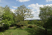
Figure 7: Probable location of another building (April 2012)
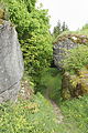
Image 8: Natural rock gate, with traces of artificial processing (April 2012)

Photo 9: Natural rock gate, counter-view (April 2012)

Photo 10: Rock formation in the front area of the castle (April 2012)
17.jpg)
03.JPG)
07.JPG)
05.JPG)
12.JPG)
13.JPG)
18.jpg)
literature
- Rüdiger Bauriedel, Ruprecht Konrad-Röder: Medieval fortifications and low-nobility mansions in the Bayreuth district . Ellwanger Druck und Verlag, Bayreuth 2007, ISBN 978-3-925361-63-0 , pp. 180 and 191.
- Hellmut Kunstmann : The castles of eastern Franconian Switzerland . Commission publisher Ferdinand Schöningh, Würzburg 1965, pp. 161–173.
- Klaus Schwarz: The prehistoric and early historical monuments in Upper Franconia . (Material booklets on Bavarian prehistory, series B, volume 5). Verlag Michael Lassleben, Kallmünz 1955, p. 81.
- Hellmut Kunstmann: Castles in Upper Franconia, ownership, building history and fates. Part 1: The castles of the noble families in the Wiesent area . Verlag EC Baumann, Kulmbach 1953, pp. 133-137.
Web links
Individual evidence
- ^ Location of the Burgstall in the Bavaria Atlas
- ↑ Source history: Hellmut Kunstmann: The castles of eastern Franconian Switzerland , p. 161 ff.
- ↑ Rüdiger Bauriedel, Ruprecht Konrad-Röder: Medieval fortifications and low-nobility mansions in the Bayreuth district , p. 180
- ↑ List of monuments for Plankenfels (PDF) at the Bavarian State Office for Monument Preservation (PDF; 128 kB)
- ↑ Geotope: Dolomite rock group W von Plankenstein (accessed on December 6, 2015)


Castles: Adlitz Castle | Althaidhof Palace | Altenplos Castle | Am Bühl Castle | Bühl Castle | Eckersdorf Castle | Emtmannsberg Castle | Hunting lodge Falkenhaube | Fantaisie Castle | Fischbach Castle | Frankenhaag Castle | Freienfels Castle | Fröbershammer Castle | Goldkronach Castle | Göppmannsbühl Castle | Guttenthau Castle | Haidenaab Castle | Heinersreuth Castle | Kainach Castle | Knopfhammer Castle | Kühlenfels Castle | Leisau Castle | Mengersdorf Castle | Mengersreuth Castle | Mistelbach Castle | Nemmersdorf Castle | Oberaufseß Castle | Hunting lodge Oberwaiz | Plankenfels Castle | Ramsenthal Castle | Reislas Castle | Sachsendorf Castle | Schnabelwaid Castle | Schönfeld Palace | Sophienberg Palace | Seybothenreuth Castle | Old Castle (Streitau) | New Castle (Streitau) | Theta Castle | Tressau Castle (exited) | Castle Trockau | Truppach Castle | Unteraufseß Castle | Unterschreez Castle | Old Castle (Weidenberg) | Lower Castle (Weidenberg) | Upper Castle (Weidenberg) | Weiher Castle (Ahorntal) | Weiher Castle (Hollfeld) | Zeulenreuth Castle
Castles and ruins: Ahorn Castle (dismissed) | Altenkünsberg Castle ( dismissed ) | Castle ruins Altes Schloss (Bad Berneck) | Betzenstein Castle (half ruin) | Böheimstein Castle (exited) | Bühl Castle | Creußen Castle (exited) | Christanz Castle (exited) | Crottendorf Castle (exited) | Crottendorf moated castle (dismissed) | Elbersberg Castle (exited) | Frankenberg Castle (Upper Franconia) | Goldeck Castle (exited) | Grünstein castle ruins | Hollenberg castle ruins | Stadtburg Hollfeld (exited) | Hohenberneck castle ruins | Kirchahorn Castle (exited) | Krögelstein castle ruins | Leienfels castle ruins | Leuenstein Castle (exited) | Leupoldstein Castle (exited) | Burgstall Lichteburg | Loch Loch (exited) | Neidenstein castle ruins | Nemschenreuth Castle (exited) | Castle ruin Niederntüchersfeld | Oberailsfeld Castle (exited) | Oberntüchersfeld Castle (exited) | Oberwiesentfels Castle (dismissed) | Plankenstein Castle (exited) | Pottenstein Castle (half ruin) | Rabeneck Castle | Rabenstein Castle | Riegelstein castle ruins | Schluesselberg Castle (exited) | Seidwitz Castle (exited) | Spies Castle (exited) | Stein Castle | Stierberg castle ruins | Unterwiesentfels Castle (exited) | Wadendorf Castle | Waischenfeld castle ruins | Wartberg Castle (exited) | Wasserknoden Castle (exited) | Wasserkraut Castle (passed) | Wiesentfels Castle | Wurzstein castle ruins
Moths (all gone): Adlitz Castle | Allersdorf Tower Hill | Tower Castle Alt-Berneck | Altencreußen Castle | Tower Aufseß | Tower hill at the castle builder | Castle Boden | Tower Hill Emtmannsberg | Motte Gefrees-Bühl | Motte Haidenschloss | Hermersreuth Tower Hill | Lochstein tower hill | Löhlitz Castle | Madersburg Tower Hill (Kroneck?) | Muthmannsreuth Castle | Reizendorf Castle | Tower Hill Castle Teinitz | Tower Hill Wallberg | Wiesentfels tower hill | Motte Witzleshofen | Castle Wünschendorf
Manor houses: Manor Bärnreuth | Christanz manor | Gutenbiegen Manor | Heckenhof manor | Manor Kotzmannsreuth | Reizendorf manor | Rosenhammer Manor | Mansion Schlösslein
Castle stables (lost, unknown castles): Burgstall Altes Schloss Bucheck | Burgstall Alte Veste | Burgstall on the Mittelberg | Burgstall Aufseß | Burgstall Bockstall | Burgstall Brunnloch | Burgstall Burgleite | Burgstall Burgstuhl | Burgstall Dürrnbühl | Burgstall im Eibental | Burgstall Galgenberg | Burgstall Big House | Burgstall Hainbronn | Burgstall Heinersreuth | Burgstall am Hühnerstein | Section fortification Hohe Warte | Burgstall Kandlberg | Burgstall Klauskirchberg (Albwinistein Castle?) | Burgstall Nankendorf | Burgstall Old House (Neuhaus) | Burgstall New House (Neuhaus) | Burgstall Rupprechtsteine | Burgstall Schlossberg (Prebitz) | Burgstall Castle Garden | Burgstall Castle Hill (Gurtstein Castle?) | Burgstall Castle Hill (Obernsees) | Burgstall Old House | Burgstall Schweinsberg | Burgstall Seelig | Burgstall Vogelsburg | Attachment to the Zottaschen (Burgstall Königstuhl)
Fortified churches: Fortified church Plech (Sankt Susannae) | Fortified church St. Marien (Gesees)