Grünstein castle ruins
| Grünstein castle ruins | ||
|---|---|---|
|
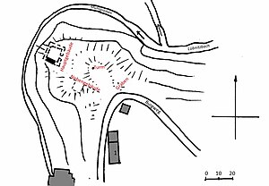
Floor plan of the castle |
||
| Creation time : | Before 1361 | |
| Castle type : | Höhenburg in spur location | |
| Conservation status: | ruin | |
| Standing position : | Manor | |
| Place: | Gefrees -Greenstone | |
| Geographical location | 50 ° 5 '21.3 " N , 11 ° 43' 34.8" E | |
| Height: | 595 m above sea level NN | |
|
|
||
Grünstein is a ruined castle in the Grünstein part of Gefrees in the Bayreuth district in Upper Franconia .
Geographical location
The ruins of the Spornburg are located on a low mountain spur at the foot of the Putzenberg, in the Schlossberg corridor, Grünstein district, at about 595 m above sea level. NN, on the northeastern outskirts of Grünstein. Mühlbach and Lübnitzbach flow around the mountain spur in parallel.
history
The castle was mentioned for the first time in a document dated May 11, 1361. With this opening document , Burgrave Friedrich allowed the Hirschbergers Hans and Arnold to build a castle "on the stone, called the green stone near Putzenreuth". The Hirschberger moved their headquarters away from the Hirschstein ruins . Today's Putzenreuth desert was about 800 meters south-east of the castle and was first mentioned in the Henneberg fiefdom register in 1317/32 .
Grünstein can first be identified as an independent manor in the first half of the 15th century. According to an imperial fiefdom from 1437, the castle was an imperial loan . Since 1447, however, Grünstein had the status of a manor that could be leased to the Bamberg Monastery. Lendings to the Lords of Hirschberg by the Bamberg bishops are documented from 1447 to 1557. In 1447 there was talk of "Hans von Hirschberg zu der Weißenstadt". In 1580 the Hirschberger sold the manor to the von Wallenrod family . The first owner was Hans Ernst von Wallenrode, bailiff von Streitberg . In 1654 the loan to the Wallenroder ended. During this time the castle must have started to fall into disrepair. In the tax register of 1733 it says: "... where there used to be a lock ...".
Political situation
The castle was in the area of tension between the Bamberg bishops and the Nuremberg burgraves . The construction of Grünstein corresponded to the expansion policy of the Nuremberg burgraves in the region and formed a counter pole to the efforts of the Bamberg bishops. The Bamberg facilities in Stein and Wasserknoden are in the immediate vicinity. The delimitation of the influence of the bishops and the burgraves in the region was long disputed and was only regulated in the Forchheim Treaty in 1538. Despite the right of opening, the Bamberg bishops exercised influence on Grünstein during the 14th century. The former Henneberg fiefdom passed to the bishops.
Appearance
On the access side of the relatively small castle area there are remains of moats. In the time of Johann Christoph Stierlein , who carried out the first topographical survey in 1795 and illustrated it with a watercolor , a square two-storey main building was still preserved at the tip of the spur. The elevation in the middle of the complex indicates another larger building or tower. Traces of trenches and outer walls are also visible . Maps of the first photo from 1852 show that the main building in particular continued to deteriorate, of which two outer walls still existed at that time. Today there are only a remnant of the wall about three meters high and an adjacent cellar.
Ground monument
The Bavarian State Office for Monument Preservation has registered the Burgstall in the Bavarian monument list under the number D-4-5936-0060 as a ground monument. The corresponding local devastation Putzenreuth is noted under the number D-4-5936-0083.
literature
- Tilmann Breuer : District of Münchberg, short inventories, XIII. Volume (book series Die Kunstdenkmäler von Bayern ). Deutscher Kunstverlag , Munich 1961, p. 16 f
- Annett Haberlah-Pohl: Historical Atlas of Bavaria , Franconia, Münchberg - The Altlandkreis (series I, volume 39). Munich 2011, ISBN 9783769665567 , p. 189 ff
- Hellmut Kunstmann : Castles in Upper Franconia II . Kulmbach 1955, pp. 116-124
- Johann Theodor Benjamin Helfrecht : Ruins, antiquities and still standing locksmiths on and on the Fichtelgebirge. One try. 1795. pp. 133f. ( online )
- Harald Stark : Castles in the Fichtel Mountains . In: Contributions to the history and regional studies of the Fichtelgebirge , issue 10. Wunsiedel 1988, pp. 45–47
- Markus Thoma: The medieval fortifications in the area around Gefrees . Historical Forum Gefrees, Issue 5, Gefrees 2011, pp. 15-17
- Markus Thoma, Claus Rabsahl, Ingo Sördert: Bad Berneck and Gefrees - A search for traces from the origins to the High Middle Ages . Historisches Forum Gefrees (Ed.), Gefrees 2013, pp. 264–267
- Markus Thoma: The medieval fortifications in the area around Gefrees. (Gefreeser Geschichte (n), Heft 5), Historisches Forum Gefrees, Gefrees 2011, pp. 15–17
- Dr. Hans Vollet and Kathrin Heckel: The ruins drawings by the Plassenburg cartographer Johann Christoph Stierlein , 1987
- Emil Wachter: The castle wreath in the Ölschnitztal . In Der Siebenstern Nr.2 / 1953 , Fichtelgebirgsverein 1953


