
Burgstall castle hill
| Burgstall castle hill | ||
|---|---|---|
 Plan of the castle after Johann Christoph Stierlein from 1791 |
||
| Alternative name (s): | Gurtstein? | |
| Creation time : | probably during the 11th century | |
| Castle type : | Hilltop castle, spur position, moth | |
| Conservation status: | Castle stable with clearly visible moats and walls | |
| Standing position : | Unknown | |
| Construction: | Wooden palisades, block construction | |
| Place: | Weidenberg - Sophienthal - "Castle Hill" | |
| Geographical location | 49 ° 57 '12.5 " N , 11 ° 46' 16.3" E | |
| Height: | 699 m above sea level NN | |
|
||

The Burgstall Schlosshügel near Weidenberg is an abandoned high-altitude castle or a ring wall system of the type of a tower hill castle (moth) from the early Middle Ages . It is located on the southern edge of the Fichtelgebirge at 699 meters above sea level above the village of Sophienthal, a district of the Markt Weidenberg in the Upper Franconian district of Bayreuth in Bavaria . The Burgstall was partially explored using probes and repeatedly mapped in the past .
history
So far, no records have been found about the castle complex, and its name has not been passed down. However, it could be the fortification "Gurtstein including the forest" mentioned in feudal deeds since 1412 . A tower was built on a strategically favorable elevation to monitor the surrounding area with eye contact to the neighboring signal hills in the Weidenberger Valley, the Upper Steinach Valley and the northern Upper Palatinate (large castle complex: Rauher Kulm ). Over time, this tower hill was expanded into a ring wall.
Local researcher Joachim Kröll wrote:
“You can see the remains particularly well, which show how a tower hill originally stood alone on the hill and how other parts of a fortification were built against it, which were secured by ditches and ramparts. The complex is set in Romanesque times, which in comparison with other tower mounds would point to the early 11th century at the latest. "
Tasks and purpose

The castle originally served as a tower hill castle (Motte) to monitor and secure the old roads and as a base for military escorts. It probably also served as a border fortification in the Franconian-Baier border region. For this purpose, it was expanded with several protective walls to make room for troop camps. Traces of these outer walls are still visible. The supply of these troops could have taken place from the hamlet of Neuhaus, to which a still existing moat was created from the area of the Kreuzstein.

Due to its location, the castle could have been an administration named "Gurtstein including the forest". Perhaps it was the first administrative base for royal forest management and medieval iron ore extraction with smelting and processing in the Steinach Valley, which was later relocated to Weidenberg. The charcoal necessary for iron extraction was produced on site in the densely wooded Fichtel Mountains with coal piles . A so-called racing furnace for the extraction of pig iron was located in the area of today's Sophienthal. The iron was processed in hammer mills on the Warmen Steinach .
Description of the plant
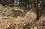
The complex consists of an oval core mound measuring 30 × 40 meters, which is surrounded by a 6 to 10 meter wide outer wall with a ditch . On the mountain side, two additional rows of walls with ditches can be seen. This created two separate areas within the ramparts, the common access of which was on the west side. The tower stood in the upper, inner area. The overall system was 200 × 90 meters in size.
As was customary at the time, the raised walls could have been raised by rows of palisades with loose rock in between. In the inner area there is a pit where the Historical Association for Upper Franconia carried out excavations in 1888/89 . In doing so, you hit the rock floor at a depth of about three meters, to which a staircase with eight steps carved into the existing mica slate leads. Possibly it is the place of the tower. There were probably farm buildings in the inner and outer areas to the north. This and the tower were made of wood.
The size of the facility indicates its national importance. It is located on a wooded hilltop with a view of the Weidenberger Tal, the northern Upper Palatinate ( Rauher Kulm ) and the opposite Bocksleite, a ridge on which a trade and military route ran in the late 8th and 9th centuries, which is now restricted by the forest . This led from Bamberg and the Upper Mainland to the Egerland . Other old roads led in a north-south direction into the interior of the Fichtelgebirge and in an east-west direction to Eger .
The Historical Association for Upper Franconia has some finds in its archive from exploratory excavations on the castle hill in the years 1846 and 1888/89. Shards of clay pots with wavy lines, coal, bones and iron remains were found. The private lecturer at the University of Bamberg, Hans Losert , published pictures of potsherds that were found on the castle hill.
Floor plan drawings

The first drawing of the Burgstall comes from Johann Christoph Stierlein in 1791 and is in the Bavarian State Library in Munich. There are also site sketches by Erich von Guttenberg from 1921 and Joachim Kröll from 1966 in his book Geschichte des Marktes Weidenberg . A geodetic survey of the facility was carried out in 1989 by Hermann Kerscher from the Bavarian State Office for Monument Preservation .
In his work on monument surveying, Hermann Kerscher compares the drawing of the ring wall by Stierlein from 1791 with the modern survey from 1989.
The Burgstall Schlosshügel was described by the Bavarian State Office for the Preservation of Monuments as a "medieval castle stable" and recorded as a ground monument under monument number 171622 file number D-4-6036-0002.
Reconstruction of the castle complex


This early castle complex from the Middle Ages was made entirely of wood. At the highest point there was a residential and defense tower. It was secured by a surrounding ditch with rows of palisades.
The outer bailey on the mountain side was probably a later extension, which was also secured with another moat and palisade. There were probably other residential and farm buildings there. The traces of the ground are still well preserved in their original form, so that they provided good reference points for the reconstruction. The palisades were probably designed in two rows and tiered in the particularly endangered places. (There are still traces of ground that might indicate this.)
For the design of the buildings, palisades and bridges, however, one was also dependent on the models of comparable systems.
Visit of the facility

Access to the castle complex is possible on foot and by bike. You start from the Sophienthal hiking car park on the Sophienthal 5 circular hiking trail run by the Fichtelgebirgsverein Weidenberg. After three kilometers to reach the remote area Neuhaus, a dialed hamlet with five former farmhouses in an idyllic forest clearing, now only a building exists from the hut as a service of the Forest Service.
Then you deviate from the circular path at the information board and follow the signs for about 500 meters to the south at the same height to the Burgstall on the left of the path.
From Neuhaus you can also get to the nearby Wurzstein castle ruins on a direct connection via the so-called Rosssteig. There is also a path to the lost hamlet of Sonnengrün.
Under the title Middle Ages in Steinachtal , information boards were set up by the Fichtelgebirge Nature Park Association at the Sophienthal hiking car park, in Neuhaus and on the castle hill.
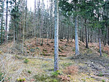
View of the Burgstall from the north
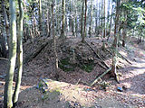
The inner area with a surrounding moat
The pit, the presumed location of the tower
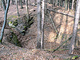
The pit with the inclined stairs
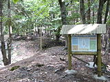
Information board at the Burgstall
Access area on the west side of the facility

View from the inner area to the information board

View from the south to the information board


literature
- Historical Association for Upper Franconia : Annual report for the years 1846/47; Description of an inspection of the ramparts on the castle hill by a committee of the association in 1843 .
- Joachim Kröll: History of the market Weidenberg . Verlag Marktgemeinde Weidenberg, complete production by Julius Steeger & Co. GmbH, Bayreuth 1967.
- Hermann Kerscher (State Office for Monument Preservation): Two hundred years of topographical monument surveying in Bavaria . Notes on early archaeological-topographical plans by the ruin cartographer Johann Christoph Stierlein, Archäologisches Jahr Bayern, Stuttgart 1989.
- Rüdiger Bauriedel, Ruprecht Konrad-Röder: Medieval fortifications and low-nobility mansions in the Bayreuth district . Ellwanger Druck und Verlag, Bayreuth 2007, ISBN 978-3-925361-63-0 , pp. 98 and 104.
- Werner Schamel: Secrets of the Castle Hill , In: "Seinerzeit ...". Local history series in the official bulletin of the administrative community Weidenberg number 14, September 30, 2008.
Individual evidence
- ↑ a b Joachim Kröll: The history of the market Weidenberg. 1967, p. 52
- ↑ Joachim Kröll: The history of the market Weidenberg. 1967, pp. 24-26
- ↑ Local supplement to the Upper Franconian School Gazette No. 309 from November 2003: Gustav Schmidt: Former ore mining and corresponding smelting in northeast and eastern Upper Franconia on page 34 in the picture: "The mining area on iron ore in the Steinach catchment area"
- ↑ Hermann Kerscher (State Office for Monument Preservation): Two hundred years of topographical monument surveying in Bavaria , comments on early archaeological-topographical plans by the ruin cartographer Johann Christoph Stierlein, Archäologisches Jahr Bayern, Stuttgart 1989, p. 207
- ↑ Map of the trade route
- ↑ Joachim Kröll: The history of the market Weidenberg. 1967, pp. 18-21
- ↑ Hans Losert: The early to high medieval ceramics in Upper Franconia. Journal of Archeology of the Middle Ages, Supplement No. 8 from 1993
- ^ Hermann Kerscher: "Two hundred years of topographical monument surveying in Bavaria". Notes on early archaeological-topographical plans by the ruin cartographer Johann Christoph Stierlein. Arch. Jahr Bayern 1989, pp. 203-207
- ↑ Route of the road network ( Memento from March 5, 2014 in the Internet Archive ) (PDF; 502 kB)


Castles: Adlitz Castle | Althaidhof Palace | Altenplos Castle | Am Bühl Castle | Bühl Castle | Eckersdorf Castle | Emtmannsberg Castle | Hunting lodge Falkenhaube | Fantaisie Castle | Fischbach Castle | Frankenhaag Castle | Freienfels Castle | Fröbershammer Castle | Goldkronach Castle | Göppmannsbühl Castle | Guttenthau Castle | Haidenaab Castle | Heinersreuth Castle | Kainach Castle | Knopfhammer Castle | Kühlenfels Castle | Leisau Castle | Mengersdorf Castle | Mengersreuth Castle | Mistelbach Castle | Nemmersdorf Castle | Oberaufseß Castle | Hunting lodge Oberwaiz | Plankenfels Castle | Ramsenthal Castle | Reislas Castle | Sachsendorf Castle | Schnabelwaid Castle | Schönfeld Palace | Sophienberg Palace | Seybothenreuth Castle | Old Castle (Streitau) | New Castle (Streitau) | Theta Castle | Tressau Castle (exited) | Castle Trockau | Truppach Castle | Unteraufseß Castle | Unterschreez Castle | Old Castle (Weidenberg) | Lower Castle (Weidenberg) | Upper Castle (Weidenberg) | Weiher Castle (Ahorntal) | Weiher Castle (Hollfeld) | Zeulenreuth Castle
Castles and ruins: Ahorn Castle (dismissed) | Altenkünsberg Castle ( dismissed ) | Castle ruins Altes Schloss (Bad Berneck) | Betzenstein Castle (half ruin) | Böheimstein Castle (exited) | Bühl Castle | Creußen Castle (exited) | Christanz Castle (exited) | Crottendorf Castle (exited) | Crottendorf moated castle (dismissed) | Elbersberg Castle (exited) | Frankenberg Castle (Upper Franconia) | Goldeck Castle (exited) | Grünstein castle ruins | Hollenberg castle ruins | Stadtburg Hollfeld (exited) | Hohenberneck castle ruins | Kirchahorn Castle (exited) | Krögelstein castle ruins | Leienfels castle ruins | Leuenstein Castle (exited) | Leupoldstein Castle (exited) | Burgstall Lichteburg | Loch Loch (exited) | Neidenstein castle ruins | Nemschenreuth Castle (exited) | Castle ruin Niederntüchersfeld | Oberailsfeld Castle (exited) | Oberntüchersfeld Castle (exited) | Oberwiesentfels Castle (dismissed) | Plankenstein Castle (exited) | Pottenstein Castle (half ruin) | Rabeneck Castle | Rabenstein Castle | Riegelstein castle ruins | Schluesselberg Castle (exited) | Seidwitz Castle (exited) | Spies Castle (exited) | Stein Castle | Stierberg castle ruins | Unterwiesentfels Castle (exited) | Wadendorf Castle | Waischenfeld castle ruins | Wartberg Castle (exited) | Wasserknoden Castle (exited) | Wasserkraut Castle (passed) | Wiesentfels Castle | Wurzstein castle ruins
Moths (all gone): Adlitz Castle | Allersdorf Tower Hill | Tower Castle Alt-Berneck | Altencreußen Castle | Tower Aufseß | Tower hill at the castle builder | Castle Boden | Tower Hill Emtmannsberg | Motte Gefrees-Bühl | Motte Haidenschloss | Hermersreuth Tower Hill | Lochstein tower hill | Löhlitz Castle | Madersburg Tower Hill (Kroneck?) | Muthmannsreuth Castle | Reizendorf Castle | Tower Hill Castle Teinitz | Tower Hill Wallberg | Wiesentfels tower hill | Motte Witzleshofen | Castle Wünschendorf
Manor houses: Manor Bärnreuth | Christanz manor | Gutenbiegen Manor | Heckenhof manor | Manor Kotzmannsreuth | Reizendorf manor | Rosenhammer Manor | Mansion Schlösslein
Castle stables (lost, unknown castles): Burgstall Altes Schloss Bucheck | Burgstall Alte Veste | Burgstall on the Mittelberg | Burgstall Aufseß | Burgstall Bockstall | Burgstall Brunnloch | Burgstall Burgleite | Burgstall Burgstuhl | Burgstall Dürrnbühl | Burgstall im Eibental | Burgstall Galgenberg | Burgstall Big House | Burgstall Hainbronn | Burgstall Heinersreuth | Burgstall am Hühnerstein | Section fortification Hohe Warte | Burgstall Kandlberg | Burgstall Klauskirchberg (Albwinistein Castle?) | Burgstall Nankendorf | Burgstall Old House (Neuhaus) | Burgstall New House (Neuhaus) | Burgstall Rupprechtsteine | Burgstall Schlossberg (Prebitz) | Burgstall Castle Garden | Burgstall Castle Hill (Gurtstein Castle?) | Burgstall Castle Hill (Obernsees) | Burgstall Old House | Burgstall Schweinsberg | Burgstall Seelig | Burgstall Vogelsburg | Attachment to the Zottaschen (Burgstall Königstuhl)
Fortified churches: Fortified church Plech (Sankt Susannae) | Fortified church St. Marien (Gesees)