
Wurzstein castle ruins
| Wurzstein castle ruins | ||
|---|---|---|
 Image 1: View of the core of the castle ruin Wurzstein from the northeast |
||
| Alternative name (s): | Pfeiferschloss | |
| Creation time : | probably during the 11th century | |
| Castle type : | Höhenburg in spur location | |
| Conservation status: | Castle stable with only a few remains of the wall | |
| Standing position : | Unknown | |
| Construction: | Phyllite rubble masonry | |
| Place: | Warmensteinach- Zainhammer | |
| Geographical location | 49 ° 58 '23.6 " N , 11 ° 46' 8.9" E | |
| Height: | 540 m above sea level NN | |
|
||

The castle ruins Wurz Stone is an Outbound probably high up late medieval nobility castle , in the Fichtel Mountains near the village Zainhammer, a district of Warmensteinach , in the Upper Franconian district of Bayreuth in Bavaria ( Germany is).
The outer bailey area of the former spur castle is freely accessible, the core bailey should not be entered.
Geographical location

The ruins of the Spornburg are located in the southern Fichtel Mountains, about 2.6 kilometers south-southwest of the parish church of the Holy Trinity in Warmensteinach, about 540 m above sea level. NN on a southwest facing spur of the Schanzberg, which is bounded on the west side by the valley of the Warmen Steinach and on the east side by the Wurzbach, about 14.5 kilometers east of Bayreuth .
Nearby, about two kilometers down the Steinach Valley, there was also a castle on the 699 meter high castle hill near the village of Sophienthal, of which only the castle stalls have been preserved. This castle could have been Gurtstein Castle. In the nearby village of Gossenreuth is the former tower castle Teinitz . Other castles in the area around the Wurzstein are believed to be on the Königsheide, west of Wurzstein Castle, on the Hohe Wacht, west of Warmensteinach with the high point 819, and on the Reizenstein near Rügersberg. Presumably prehistoric fortifications could also have been located on the Schanzberg.
History of the castle


The history of Wurzstein Castle is not yet exactly known, also because no archaeological excavation has taken place there. On October 19, 1985, during an inspection by the State Office for Monument Preservation, ceramics from the late Middle Ages and the early modern period , two parts of a bronze fitting and iron parts were found.
In older literature, Wurzstein Castle is sometimes confused with Gurtstein Castle or referred to as the "Pfeiferschloss". The Gurtstein Castle is probably the castle on the castle hill near Sophienthal, but the name Pfeiferschloss could well refer to the Wurzstein Castle, as the so-called Pfeiferhaus in the immediate vicinity is sometimes associated with the ruins in older literature was brought on the root. The Pfeiferhaus was named after the neighboring Pfeifer forest department and is said to have vaulted cellars and strong walls; it could perhaps have been a fortified farm yard of Wurzstein Castle.
The earliest written mention could be after the historian Dr. Ruprecht Konrad Roeder have taken place already in 1069, with a donation document handed King Henry IV. The Bamberger Bishop Hermann I and his church, the Good "Wrzaha" which can be translated Wurzbach. This could mean the village of Wurzbach, today a desert , and Wurzstein Castle.
Wurzstein Castle could have been built as a protection system for the nearby mines called Help God, Compromised Luck, Wild Wolves, Golden Goose, Heavenly Army, etc., where iron ore , silver and probably gold were mined.
It could also have served as a border fortification between the dioceses of Bamberg and Regensburg . Later it passed to the burgraves of Nuremberg , who enfeoffed the lords of Weidenberg , Künsberg and Lindenfels with the castle.
In 1679 the "Old Castle in Wurzbach" was mentioned during a tour of the mine; In 1692, the pastor from Creußen, Magister Johann Will, only found the "Rudera of the old Wurzstein Castle", ie the ruins of the castle.
The cartographer Johann Christoph Stierlein completed a very precise map of the castle area for the first time in 1816 with the existing inventory.
It is not known whether the castle was destroyed in a war or whether it was abandoned due to lack of importance.
The ground monument registered by the Bavarian State Office for the Preservation of Monuments as "medieval castle ruin Wurzstein" has the monument number D-4-6036-0003.
description

The former castle was at the top of a mountain spur that extends from the Schanzberg to the southwest (Fig. 2). This spur forms a rocky elevation there, which on the southeast side drops about 20 meters vertically into the valley of the Wurzbach (Fig. 4), on the south (Fig. 5) and northwest side (Fig. 6) steeply to the Wurzbach and Warmen Steinach. On the northeast side of the castle complex, the spur continues to rise after a small, relatively flat area, so that a neck ditch had to be created there to secure this endangered side.
This ditch cuts through the spur, bends 90 degrees on the east side (Fig. 7), and then runs out on the slope to the Wurzbach. The moat also makes a 90-degree bend on the west side (Fig. 8) and then merges into the area of the kennel, which protected the entire west side of the main castle.
In front of the neck ditch there is a flat surface (Fig. 9), after which the mountain spur continues to rise; there was probably a bailey there .
The area of the inner castle (Fig. 1) has an irregular oval shape and was enclosed by a circular wall. At the extreme tip of the spur there was probably a keep , of which only the foundation walls remain (Fig. 10). Subsequently, shows a depression (Figure 11) well the location of the Palas on. Also on the highest point of the castle ruins (Fig. 12) was a presumably tower-like building, of which several remains of the wall still exist (Fig. 3 and 13).
On the western side of the castle there was probably a kennel (Fig. 14), which could perhaps also be used as a castle courtyard. There was probably also a cistern in it .

Image 4: The south-east side of the inner castle area
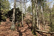
Photo 5: The top of the mountain spur

Image 6: The southwest side of the inner castle area

Photo 7: Eastern part of the neck ditch
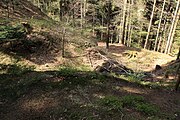
Photo 8: Western part of the neck ditch

Photo 9: The area of the outer bailey

Photo 10: The place of the keep

Image 11: The presumed location of the hall

Photo 12: The highest point of the Wurzstein castle ruins
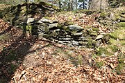
Image 13: Remnants of the wall in the inner castle

Photo 14: Kennel area on the west side of the inner castle


literature
- Harald Herrmann: Wurzstein Castle Ruins in Steinachtal - A Typological Study . 1st edition. Heinrichs-Verlag GmbH, Bamberg 2008, ISBN 978-3-89889-130-1 .
- Rüdiger Bauriedel, Ruprecht Konrad-Röder: Medieval fortifications and low-nobility mansions in the Bayreuth district . Published by the district of Bayreuth, Ellwanger Druck und Verlag, Bayreuth 2007, ISBN 978-3-925361-63-0 , p. 81.
Web links
Individual evidence
- ↑ Information board at the Burgstall
- ^ The tower hill on the side of the Bavarian State Office for Monument Preservation
- ↑ Herrmann 2008, p. 82 ff
- ↑ Rüdiger Bauriedel, Ruprecht Konrad-Röder 2007, p. 98
- ↑ Herrmann 2008, p. 79 ff
- ↑ Hans Füssmann, Ludwig Spöttel: Materials on a local history of Warmensteinach and the surrounding area
- ↑ Wurzstein castle ruins on the website of the Bavarian State Office for Monument Preservation


Castles: Adlitz Castle | Althaidhof Palace | Altenplos Castle | Am Bühl Castle | Bühl Castle | Eckersdorf Castle | Emtmannsberg Castle | Hunting lodge Falkenhaube | Fantaisie Castle | Fischbach Castle | Frankenhaag Castle | Freienfels Castle | Fröbershammer Castle | Goldkronach Castle | Göppmannsbühl Castle | Guttenthau Castle | Haidenaab Castle | Heinersreuth Castle | Kainach Castle | Knopfhammer Castle | Kühlenfels Castle | Leisau Castle | Mengersdorf Castle | Mengersreuth Castle | Mistelbach Castle | Nemmersdorf Castle | Oberaufseß Castle | Hunting lodge Oberwaiz | Plankenfels Castle | Ramsenthal Castle | Reislas Castle | Sachsendorf Castle | Schnabelwaid Castle | Schönfeld Palace | Sophienberg Palace | Seybothenreuth Castle | Old Castle (Streitau) | New Castle (Streitau) | Theta Castle | Tressau Castle (exited) | Castle Trockau | Truppach Castle | Unteraufseß Castle | Unterschreez Castle | Old Castle (Weidenberg) | Lower Castle (Weidenberg) | Upper Castle (Weidenberg) | Weiher Castle (Ahorntal) | Weiher Castle (Hollfeld) | Zeulenreuth Castle
Castles and ruins: Ahorn Castle (dismissed) | Altenkünsberg Castle ( dismissed ) | Castle ruins Altes Schloss (Bad Berneck) | Betzenstein Castle (half ruin) | Böheimstein Castle (exited) | Bühl Castle | Creußen Castle (exited) | Christanz Castle (exited) | Crottendorf Castle (exited) | Crottendorf moated castle (dismissed) | Elbersberg Castle (exited) | Frankenberg Castle (Upper Franconia) | Goldeck Castle (exited) | Grünstein castle ruins | Hollenberg castle ruins | Stadtburg Hollfeld (exited) | Hohenberneck castle ruins | Kirchahorn Castle (exited) | Krögelstein castle ruins | Leienfels castle ruins | Leuenstein Castle (exited) | Leupoldstein Castle (exited) | Burgstall Lichteburg | Loch Loch (exited) | Neidenstein castle ruins | Nemschenreuth Castle (exited) | Castle ruin Niederntüchersfeld | Oberailsfeld Castle (exited) | Oberntüchersfeld Castle (exited) | Oberwiesentfels Castle (dismissed) | Plankenstein Castle (exited) | Pottenstein Castle (half ruin) | Rabeneck Castle | Rabenstein Castle | Riegelstein castle ruins | Schluesselberg Castle (exited) | Seidwitz Castle (exited) | Spies Castle (exited) | Stein Castle | Stierberg castle ruins | Unterwiesentfels Castle (exited) | Wadendorf Castle | Waischenfeld castle ruins | Wartberg Castle (exited) | Wasserknoden Castle (exited) | Wasserkraut Castle (passed) | Wiesentfels Castle | Wurzstein castle ruins
Moths (all gone): Adlitz Castle | Allersdorf Tower Hill | Tower Castle Alt-Berneck | Altencreußen Castle | Tower Aufseß | Tower hill at the castle builder | Castle Boden | Tower Hill Emtmannsberg | Motte Gefrees-Bühl | Motte Haidenschloss | Hermersreuth Tower Hill | Lochstein tower hill | Löhlitz Castle | Madersburg Tower Hill (Kroneck?) | Muthmannsreuth Castle | Reizendorf Castle | Tower Hill Castle Teinitz | Tower Hill Wallberg | Wiesentfels tower hill | Motte Witzleshofen | Castle Wünschendorf
Manor houses: Manor Bärnreuth | Christanz manor | Gutenbiegen Manor | Heckenhof manor | Manor Kotzmannsreuth | Reizendorf manor | Rosenhammer Manor | Mansion Schlösslein
Castle stables (lost, unknown castles): Burgstall Altes Schloss Bucheck | Burgstall Alte Veste | Burgstall on the Mittelberg | Burgstall Aufseß | Burgstall Bockstall | Burgstall Brunnloch | Burgstall Burgleite | Burgstall Burgstuhl | Burgstall Dürrnbühl | Burgstall im Eibental | Burgstall Galgenberg | Burgstall Big House | Burgstall Hainbronn | Burgstall Heinersreuth | Burgstall am Hühnerstein | Section fortification Hohe Warte | Burgstall Kandlberg | Burgstall Klauskirchberg (Albwinistein Castle?) | Burgstall Nankendorf | Burgstall Old House (Neuhaus) | Burgstall New House (Neuhaus) | Burgstall Rupprechtsteine | Burgstall Schlossberg (Prebitz) | Burgstall Castle Garden | Burgstall Castle Hill (Gurtstein Castle?) | Burgstall Castle Hill (Obernsees) | Burgstall Old House | Burgstall Schweinsberg | Burgstall Seelig | Burgstall Vogelsburg | Attachment to the Zottaschen (Burgstall Königstuhl)
Fortified churches: Fortified church Plech (Sankt Susannae) | Fortified church St. Marien (Gesees)