Burgstall Böheimstein
| Burgstall Böheimstein | ||
|---|---|---|
|
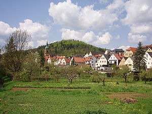
View of the city of Pegnitz and the Schlossberg in the background |
||
| Alternative name (s): | Veste Pegnitz | |
| Creation time : | Probably between 1347 and 1357 | |
| Castle type : | Höhenburg, summit location | |
| Conservation status: | Burgstall | |
| Standing position : | Landgraves | |
| Place: | Pegnitz | |
| Geographical location | 49 ° 45 '28.6 " N , 11 ° 31' 57.7" E | |
| Height: | 543 m above sea level NHN | |
|
|
||
The Burgstall Böheimstein , formerly also called Burg Pegnitz , was probably a castle founded by the Landgraves von Leuchtenberg in the late Middle Ages on the Schlossberg above the town of Pegnitz in the Upper Franconian district of Bayreuth in Bavaria .
The castle stable of the Gipfelburg is freely accessible and serves as a lookout point with the observation tower built in 1923.
Geographical location
The remains of the former castle are on the summit of the 543 meter high Schlossberg , approx. 500 meters west of the market square of the town of Pegnitz in the Franconian Switzerland-Veldenstein Forest Nature Park .
You can easily reach the Schlossberg with the castle stable, which was exposed in 1873, and the observation tower on hiking trails from Pegnitz.
Nearby, in a westerly direction, are the Hollenberg castle ruins , and Pottenstein Castle a little further on . In a north-westerly direction lies the Burgstall Wartberg on the Warenberg, in the southeast the castle ruins Steinamwasser and in the south the Burgstall Stein in the village of the same name.
There was also a castle at the foot of the Schlossberg in the area of the city of Pegnitz. It was mentioned for the first time in 1408: "a whale located under Böheimstein". A "Gotescalc von Paichinze", which was mentioned in a document in 1179, was probably sitting on it. But nothing can be seen of this castle.
History of the castle
In 1347, due to the extinction of the previous owner, the Schlüsselberger , the Landgraves of Leuchtenberg acquired the town of Pegnitz, of which only the old town existed at that time , through the death of Konrad II von Schlüsselberg at Neideck Castle . The Leuchtenbergers expanded their new territory by building the Pegnitzer Neustadt as an economic center between 1347 and 1357. It can be assumed that they also built Pegnitz Castle on the Schlossberg during the ten years of their rule, because when the landgraves sold their area around the city of Pegnitz to Emperor Charles IV in 1357 , the sales deeds repeatedly mentioned a fortress, i.e. a castle, written.
Another argument against building the castle under Emperor Karl is that between the acquisition of the area around Pegnitz on November 16, 1357 and its first mention on June 25, 1358 as "Böheimstein", he only had seven to eight months, especially during the winter, Would have had time to do so, in which no castle could be built at that time.
Under Emperor Karl, who was also King of Bohemia , the castle was renamed Böheimstein, the name should probably glorify his New Bohemian Empire. Emperor Karl had Böheimstein Castle strengthened, and a keep was also built, perhaps on the site of today's observation tower. In addition to Hollenberg Castle, Böheimstein also became the official seat . The first Bohemian orderly came from the Stiebar von Buttenheim family .
After the death of Emperor Karl in 1378, the castle changed hands frequently during the city war , from which the burgraves of Nuremberg emerged as the new owners in 1402 and who became the margraves of Brandenburg-Kulmbach in 1427 . The Hohenzollern also established a seat of the Böheimstein office at the castle from 1405 to 1553 .
During the frequent armed conflicts in the city war, the Hussite incursions , the First Margrave War , the Prince's War from 1460 to 1462 and the Peasant War , only the city of Pegnitz was devastated, but not Böheimstein Castle.
The end of the castle came in the Second Margrave War , in which Albrecht II Alcibiades, among others, moved against the imperial city of Nuremberg . The Nuremberg troops under Haug von Parsberg besieged the margravial castle on June 26, 1553 and shot it ready for storm the next day. The next day the defenders surrendered and the castle was looted and burned.
After the destruction of Böheimstein Castle, the official residence was relocated to Altenstadt Castle in Pegnitz.
Description of the castle stables
In 1792, Johann Christoph Stierlein made a true-to-scale topographical map of the castle ruins and their immediate surroundings. He recognized clear continuous traces of several foundation walls and a ditch .
Web links
- Reconstruction drawing by Wolfgang Braun
- Entry on Böheimstein in the private database "Alle Burgen".
literature
- Rüdiger Bauriedel, Ruprecht Konrad-Röder: Medieval fortifications and low-nobility mansions in the Bayreuth district . Ellwanger Druck und Verlag, Bayreuth 2007, ISBN 978-3-925361-63-0 , p. 118.
- Gerhard Philipp Wolf, Walter Thousand Pounds: Pegnitz-Veldensteiner Forest: Historical Forays . Palm and Enke Verlag, Erlangen 1986, ISBN 3-7896-0072-5 , p. 30 ff.
- Hellmut Kunstmann : The castles of eastern Franconian Switzerland . Commission publisher Ferdinand Schöningh, Würzburg 1965, pp. 379–391.
- Hans Vollet and Kathrin Heckel: The ruins drawings by the Plassenburg cartographer Johann Christoph Stierlein . 1987.
- Toni Eckert, Susanne Fischer, Renate Freitag, Rainer Hofmann, Walter Thousand Pounds: The Castles of Franconian Switzerland: A cultural guide . Gürtler Druck, Forchheim o. J., ISBN 3-9803276-5-5 , pp. 32-34.


