
Stierberg castle ruins
| Stierberg castle ruins | ||
|---|---|---|
 View of the village and castle ruins of Stierberg from the north-west |
||
| Creation time : | around 1200 | |
| Castle type : | Höhenburg, spur location | |
| Conservation status: | ruin | |
| Standing position : | Ministeriale | |
| Construction: | Quarry stone masonry, partly with small cuboid facing | |
| Place: | Betzenstein - Stierberg - "Schlossberg" | |
| Geographical location | 49 ° 40 '39.1 " N , 11 ° 23' 16.8" E | |
| Height: | 580 m above sea level NN | |
|
||

The Stierberg castle ruins were a high medieval aristocratic castle above the village of Stierberg , a western part of Betzenstein in the Upper Franconian district of Bayreuth in Bavaria .
The upper castle of the ruin is freely accessible, a large part of the lower castle is privately owned by the Thilo Glas family from Erlangen and cannot be entered.
Geographical location
The Stierberg castle ruins are located in the Franconian Switzerland-Veldenstein Forest Nature Park on the Schlossberg (east summit 559 m , north-east summit 596 m and south-west summit 594 m above sea level ) near the village of Stierberg , which is around 2.3 km west-southwest of the church in Betzenstein. The ruin is located southeast of the village on the saddle between the two highest peaks of the Schlossberg at around 580 m above sea level. NN .
The spur castle consisted of an upper castle on a rocky reef of the saddle and a lower castle at the western foot of the reef.
The best way to reach the ruins is from the village on the signposted path.
Nearby, to the east, you can see Betzenstein Castle. In the north are the Leupoldstein Castle Stables and the Leienfels Castle ruins . To the south of Stierberg stood the castles Wildenfels , Strahlfels , Spies and Riegelstein .
History of the castle
The name Stierberg appeared for the first time in 1187 with the mention of "Otnand de Stierberc", a Bamberg cathedral canon. In 1188 and 1216 a "Poppo von Stierberg" appeared, probably a brother of Otnand. It is unlikely that the Bamberg ministerials built the castle. The family died out between 1281 and 1285, and the castle fell to the diocese of Bamberg.
In 1308 the castle was mentioned for the first time in a will of the noble free Gottfried von Schlüsselberg . In 1323/27 it appeared in an episcopal land register as the "castrum" of the Bamberg diocese. Before that, Stierberg Castle had already passed to the Leuchtenbergers , who were related to the Schlüsselbergers . The castle was probably pledged to the Leuchtenbergers and was no longer released by the Bamberg diocese. Landgrave Ulrich von Leuchtenberg had entrusted them to Archbishop Balduin von Trier's fiefdom in 1316, probably to secure his title to the diocese of Bamberg.
In 1356 the castle was sold to the Bohemian Emperor Charles IV . As a result of their feud with the diocese of Bamberg, the Leuchtenbergers had to sell their fiefdom to the Nuremberg patrician Peter Haller in 1400, but in 1407 the castle was back in their hands. In 1417 it had to be finally sold by the Leuchtenbergers to the Count Palatine Johann von Neumarkt-Neuenburg .
In the Landshut War of Succession , the castle was captured by the Nuremberg people on July 2, 1504, and in October 1504 the Palatinate war captain Ludwig von Eyb the Younger of Hartenstein recaptured it . This resulted in damage to the lower castle. Due to the victorious outcome of the War of Succession, the castle came to the people of Nuremberg in 1505, who repaired it by 1515 and made it the seat of a maintenance office.
The Second Margrave War brought the castle to an end. In 1553 it was shot at, captured and then burned down by Margrave Albrecht Alcibiades . In 1555 work began on rebuilding, but it was stopped shortly afterwards. The caretaker should look for a seat in Betzenstein, so the Stierberg Castle became superfluous. During the 16th century, the lower castle was still repaired and a Vogthaus, a grain box and various farm buildings were built. Due to dilapidation, the Vogthaus was replaced by a new building in 1778, and the grain box disappeared again in 1799.
In 1806 there were still considerable remains of the castle, in the 19th and 20th centuries there were great losses, probably it was used as a quarry.
Description of the castle ruins

The Stierberger Schloßberg is a long, wooded rocky reef that stretches from northeast to southwest. The reef slopes mostly vertically on its sides. In front of the southwestern end there is a saddle that separates part of the rock reef from the rest of the mountain (Fig. 1). This reef was used to build the upper castle. It drops vertically up to approx. 20 meters on almost all sides, only the access side in the northeast rises steeply by approx. 18 meters. Another staircase was probably in the southeast, from the walled place in front of the southern exit of the castle cave. There was a steep, ravine-like climb up stairs.
On the upper castle with an area of approx. 60 × 30 meters, only a few remains of the curtain wall and a tower, probably the keep , have been preserved. The remains of the wall only have their ashlar facing in the south of the upper castle and on the northwest side of the tower (Fig. 2), which is also threatened with decay. A large remnant of the wall (Fig. 3), probably a building, still stands on the northeast side of the upper castle, it is approx. 11 meters long, 6 to 8 meters high and 1.3 meters wide and has two supporting pillars and a corbel on its outside . This wall remnant probably belonged to the large bower in the southeast part of the upper castle. Kunstmann suspects a small bower next to the large one. Other buildings of the upper castle were the already mentioned tower (Fig. 4) and a cistern, of which nothing can be seen. The ascent was located in the northeast of the rocky reef and started from the lower saddle, presumably via stairs, through a gatehouse or a gate tower, as can be seen in an engraving by L. Schlemmer from 1799.
The lower castle was about 20 meters below the upper castle at the northwestern foot of the rocky reef and in the saddle in the north. There is not much left to see of her. The Bailiwick House from 1778 is now in the area of the lower castle (Fig. 5). All that remains of the former grain box are traces of the terrain and the remains of a foundation wall. The approach from the village of Stierberg in the northwest was a gate lane in the area of the lower castle. There used to be a gatehouse or gate tower at the entrance to the lower castle. A second cistern can be seen in the south of the lower castle (Fig. 6). At the northern end of the lower castle there is a round tower visible from afar on a rock tower (Fig. 7). The tower is made of quarry stone and has a diameter of 5.5, a wall thickness of 1.3 and a height of six meters. Its arched entrance in the direction of the lower castle was only accessible with a ladder. The tower was covered with bricks, as shown by the remains of bricks below the tower. It served to defend the castle against attacks from the north and was included in the walling of the lower castle.
The castle cave is a special feature. The natural cave was artificially enlarged and probably served, among other things, as the cellar of the castle (Fig. 8). It runs through the rock reef of the upper castle and had three entrances, one in the north (Fig. 9) in the area of the lower castle, one in the south of the rock reef (Fig. 10) and one in the west of the rock reef. The opening in the west was walled up except for a notch, but is now completely blocked. In front of the southern exit, which is walled up except for a small square opening, a shield wall-like fortification was built at a distance of approx. 2 to 4 meters (Fig. 11 and 12). It is unclear whether it had an opening to the outside world. It forms a small forecourt formed by the wall and the rocky reef, from which the above-mentioned gorge-like second staircase led up to the upper castle. The ascent led upward on steep stairs between the rock reef and a rock tower in front of it on the slope of a short saddle that connected rock reef and rock tower. The purpose of this facility is unclear. Perhaps it was used to stab an enemy who had penetrated the lower castle in the rear, or to bring supplies from the cave cellar to the upper castle, perhaps also by elevator. There was probably also a tower on top of the rock tower.

Photo 1: The rocky reef on which the upper castle of the Stierberg ruins lay, from the north
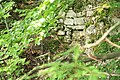
Photo 2: Remnants of the wall in the southern upper castle with the ashlar facing still preserved

Image 3: The northeastern wall of the Stierberg castle seen from below
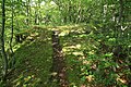
Photo 4: The place of the tower on the upper castle

Photo 5: The Vogteihaus in the lower castle
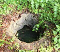
Image 6: The cistern of the lower castle

Photo 7: The tower of the lower castle from the south
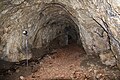
Photo 8: In the castle cave

Photo 9: The northern entrance to the castle cave in the lower castle

Photo 10: The now walled-up exit of the castle cave

Image 11: The wall in front of the exit of the castle cave

Photo 12: The wall in front of the southern exit of the cave


literature
- Rüdiger Bauriedel, Ruprecht Konrad-Röder: Medieval fortifications and low-nobility mansions in the Bayreuth district . Ellwanger Druck und Verlag, Bayreuth 2007, ISBN 978-3-925361-63-0 , p. 136.
- Robert Giersch, Andreas Schlunk, Berthold Frhr. von Haller: Castles and mansions in the Nuremberg countryside . Altnürnberger Landschaft, Lauf an der Pegnitz 2006, ISBN 978-3-00-020677-1 , pp. 430-432.
- Ursula Pfistermeister : Wehrhaftes Franken - Volume 3: Castles, fortified churches, city walls around Bamberg, Bayreuth and Coburg , Fachverlag Hans Carl GmbH, Nuremberg 2002, ISBN 3-418-00387-7 , pp. 118–119.
- Toni Eckert, Susanne Fischer, Renate Freitag, Rainer Hofmann, Walter Thousand Pounds: The castles of Franconian Switzerland . Gürtler Druck, Forchheim, ISBN 3-9803276-5-5 , pp. 138-142.
- Hellmut Kunstmann : The castles of eastern Franconian Switzerland . Commission publisher Ferdinand Schöningh, Würzburg 1965, pp. 460–481.
Web links
- Burgruine Stierberg on the Burgenwelt.de page
- Stierberg castle ruins on the castles and manors side in the Nuremberg countryside
- Reconstruction drawing by Wolfgang Braun
Individual evidence
- ↑ a b map services ( memento of the original from December 19, 2012 in the Internet Archive ) Info: The archive link was inserted automatically and has not yet been checked. Please check the original and archive link according to the instructions and then remove this notice. of the BfN


Castles: Adlitz Castle | Althaidhof Palace | Altenplos Castle | Am Bühl Castle | Bühl Castle | Eckersdorf Castle | Emtmannsberg Castle | Hunting lodge Falkenhaube | Fantaisie Castle | Fischbach Castle | Frankenhaag Castle | Freienfels Castle | Fröbershammer Castle | Goldkronach Castle | Göppmannsbühl Castle | Guttenthau Castle | Haidenaab Castle | Heinersreuth Castle | Kainach Castle | Knopfhammer Castle | Kühlenfels Castle | Leisau Castle | Mengersdorf Castle | Mengersreuth Castle | Mistelbach Castle | Nemmersdorf Castle | Oberaufseß Castle | Hunting lodge Oberwaiz | Plankenfels Castle | Ramsenthal Castle | Reislas Castle | Sachsendorf Castle | Schnabelwaid Castle | Schönfeld Palace | Sophienberg Palace | Seybothenreuth Castle | Old Castle (Streitau) | New Castle (Streitau) | Theta Castle | Tressau Castle (exited) | Castle Trockau | Truppach Castle | Unteraufseß Castle | Unterschreez Castle | Old Castle (Weidenberg) | Lower Castle (Weidenberg) | Upper Castle (Weidenberg) | Weiher Castle (Ahorntal) | Weiher Castle (Hollfeld) | Zeulenreuth Castle
Castles and ruins: Ahorn Castle (dismissed) | Altenkünsberg Castle ( dismissed ) | Castle ruins Altes Schloss (Bad Berneck) | Betzenstein Castle (half ruin) | Böheimstein Castle (exited) | Bühl Castle | Creußen Castle (exited) | Christanz Castle (exited) | Crottendorf Castle (exited) | Crottendorf moated castle (dismissed) | Elbersberg Castle (exited) | Frankenberg Castle (Upper Franconia) | Goldeck Castle (exited) | Grünstein castle ruins | Hollenberg castle ruins | Stadtburg Hollfeld (exited) | Hohenberneck castle ruins | Kirchahorn Castle (exited) | Krögelstein castle ruins | Leienfels castle ruins | Leuenstein Castle (exited) | Leupoldstein Castle (exited) | Burgstall Lichteburg | Loch Loch (exited) | Neidenstein castle ruins | Nemschenreuth Castle (exited) | Castle ruin Niederntüchersfeld | Oberailsfeld Castle (exited) | Oberntüchersfeld Castle (exited) | Oberwiesentfels Castle (dismissed) | Plankenstein Castle (exited) | Pottenstein Castle (half ruin) | Rabeneck Castle | Rabenstein Castle | Riegelstein castle ruins | Schluesselberg Castle (exited) | Seidwitz Castle (exited) | Spies Castle (exited) | Stein Castle | Stierberg castle ruins | Unterwiesentfels Castle (exited) | Wadendorf Castle | Waischenfeld castle ruins | Wartberg Castle (exited) | Wasserknoden Castle (exited) | Wasserkraut Castle (passed) | Wiesentfels Castle | Wurzstein castle ruins
Moths (all gone): Adlitz Castle | Allersdorf Tower Hill | Tower Castle Alt-Berneck | Altencreußen Castle | Tower Aufseß | Tower hill at the castle builder | Castle Boden | Tower Hill Emtmannsberg | Motte Gefrees-Bühl | Motte Haidenschloss | Hermersreuth Tower Hill | Lochstein tower hill | Löhlitz Castle | Madersburg Tower Hill (Kroneck?) | Muthmannsreuth Castle | Reizendorf Castle | Tower Hill Castle Teinitz | Tower Hill Wallberg | Wiesentfels tower hill | Motte Witzleshofen | Castle Wünschendorf
Manor houses: Manor Bärnreuth | Christanz manor | Gutenbiegen Manor | Heckenhof manor | Manor Kotzmannsreuth | Reizendorf manor | Rosenhammer Manor | Mansion Schlösslein
Castle stables (lost, unknown castles): Burgstall Altes Schloss Bucheck | Burgstall Alte Veste | Burgstall on the Mittelberg | Burgstall Aufseß | Burgstall Bockstall | Burgstall Brunnloch | Burgstall Burgleite | Burgstall Burgstuhl | Burgstall Dürrnbühl | Burgstall im Eibental | Burgstall Galgenberg | Burgstall Big House | Burgstall Hainbronn | Burgstall Heinersreuth | Burgstall am Hühnerstein | Section fortification Hohe Warte | Burgstall Kandlberg | Burgstall Klauskirchberg (Albwinistein Castle?) | Burgstall Nankendorf | Burgstall Old House (Neuhaus) | Burgstall New House (Neuhaus) | Burgstall Rupprechtsteine | Burgstall Schlossberg (Prebitz) | Burgstall Castle Garden | Burgstall Castle Hill (Gurtstein Castle?) | Burgstall Castle Hill (Obernsees) | Burgstall Old House | Burgstall Schweinsberg | Burgstall Seelig | Burgstall Vogelsburg | Attachment to the Zottaschen (Burgstall Königstuhl)
Fortified churches: Fortified church Plech (Sankt Susannae) | Fortified church St. Marien (Gesees)