Gefrees
| coat of arms | Germany map | |
|---|---|---|

|
Coordinates: 50 ° 6 ′ N , 11 ° 44 ′ E |
|
| Basic data | ||
| State : | Bavaria | |
| Administrative region : | Upper Franconia | |
| County : | Bayreuth | |
| Height : | 500 m above sea level NHN | |
| Area : | 50.3 km 2 | |
| Residents: | 4295 (Dec. 31, 2019) | |
| Population density : | 85 inhabitants per km 2 | |
| Postcodes : | 95482, 95236 | |
| Area code : | 09254 | |
| License plate : | BT, EBS , ESB , KEM , MÜB , PEG | |
| Community key : | 09 4 72 139 | |
| LOCODE : | DE ZGS | |
| City structure: | 44 districts | |
City administration address : |
Main street 22 95482 Gefrees |
|
| Website : | ||
| Mayor : | Oliver Dietel (constituency Gefrees-Land ) | |
| Location of the town of Gefrees in the Bayreuth district | ||
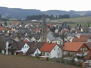
Gefrees is a town in the district of Bayreuth in the Bavarian administrative district of Upper Franconia .
geography
Geographical location
The town lies on the outer slope of the western horseshoe leg of the Fichtelgebirge between Waldstein and Ochsenkopf . The Münchberger Gneissplatte opens up in the north, the foothills of the Franconian Forest approach from the west and the Main Valley extends to the west in the south.
Oelschnitz , Lübnitz and Kornbach flow through the urban area . The latter comes from the Gefrees district of the same name and flows into the city of the Lübnitz, which flows into the Oelschnitz between Böseneck and the Entenmühle.
City structure
There are 44 districts :
|
|
|
Lochnerseinzel is not an officially named district.
Neighboring communities
In the northernmost "tip" of the district Bayreuth located about 26 kilometers north of the county town of Bayreuth , surrounded Gefrees in the south the municipality Bischofsgrün and the city of Bad Berneck , in the western district of Kulmbach with the market Marktschorgast , north of the district court with the Markets Stammbach and Zell and in the east the district of Wunsiedel in the Fichtelgebirge with the city of Weißenstadt .
Surname
The place name is derived from the Middle High German word Gevreatze , which means "eating" or "gourmet". The location at an important intersection of European dimensions shaped the place and made it a resting place. In Gefrees, an old road branched off from the Via Imperii to Eger via the Höllpass , Weißenstadt and Röslau to the east, while a high road went west via Burgkunstadt towards Frankfurt am Main and via Bamberg to Würzburg .
history
Until the church is planted
Since 1336 Gefrees belonged to the rule of the Zollern burgraves of Nuremberg , who later became the margraves of Brandenburg-Bayreuth . In 1366, the place was first mentioned in writing in an arbitration award that ended a dispute between the parishes of Marktschorgast and Münchberg over responsibility for Gefrees. In documents from the years 1403 and 1444, Gefrees is mentioned. From 1500 the city was part of the Franconian Empire .
In 1557 the residents were still required to get their beer from Bayreuth , in 1581 Ungeld , a tax on locally brewed beer, was paid. In 1692 five inns were mentioned, in 1721 there was a pharmacy. In 1875, 16 bakers and 27 butchers were based in Gefrees, which had around 1500 inhabitants at that time.
During the Thirty Years' War Gefrees was damaged several times. B. 1632 of 200 invading Croatians. In May 1815 Napoleon returned to Prussia and in 1838 Tsarevich Alexander of Russia came to the town.
The Upper Office of the Prussian Principality of Bayreuth , which had been Prussian since 1792 , fell to France in the Peace of Tilsit in 1807 and was sold by Napoleon to the Kingdom of Bavaria in 1810 . In 1809 the battle of Gefrees took place, in the course of which 6,000 Austrians escaped being surrounded by 7,500 French. Around 2,400 dead or wounded were counted.
Gefrees had the town charter with its own magistrate rights. In the course of the administrative reforms in Bavaria, the municipality of Gefrees was created with the municipal edict of 1818 with the villages of Böseneck, Cremitz, Gefrees, Grünhügel, Grünstein, Kastenmühle, Lübnitz, Neuenreuth, Oberneuenreuth and Wundenbach.
19th and 20th centuries
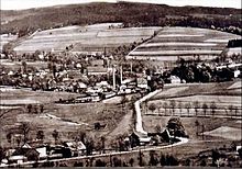
Before 1872 the houses with their gables faced the main street, while the church was parallel to it. The old town hall was located near the church. During the devastating city fire that year, the place was almost completely destroyed. A new town hall was built elsewhere, the orientation of the houses and the Johanneskirche, which was newly built in 1878, changed. Trade and industry, u. a. the Großmann furniture factory , gave the place increasing importance. In 1900 the construction of a railway line was approved, on July 5, 1902, the first train reached the place from Falls.
Until 1929 Gefrees belonged to the Berneck District Office , after its dissolution, initially to the Bayreuth District Office until 1931 and since then to the District Office and, from 1939, the Münchberg District . As part of the Bavarian district reform, the city joined the Bayreuth district on July 1, 1972 after a vote .
On September 27, 1936, the Schleiz – Berneck section of the Munich – Berlin Reichsautobahn was released . In 1973 the transport of passengers by rail was stopped, in 1993 the transport of goods by rail was stopped, and the line to Falls was closed and dismantled. In 2005, the last railway connection, the Falls stop, last only stop on demand, was closed.
Incorporations
Wundenbach was incorporated as early as August 1, 1926. Grünstein followed on April 1, 1927.
On July 1, 1971, the previously independent communities of Lützenreuth and Zettlitz were incorporated. Kornbach was added on July 1, 1972. Metzlersreuth followed on January 1, 1973. The incorporation of the formerly independent communities of Falls, Streitau and Witzleshofen, which came into force on May 1, 1978, rounded off the number of incorporations.
Population development
In the period from 1988 to 2018, the population fell from 4,731 to 4,332 by 399 or 8.4%. A peak was reached on December 31, 1995 with 4992 inhabitants.
politics
City council
The local elections in 2002 and 2008 resulted in the following distribution of seats in the city council:
| election day | CSU | SPD | FW | Gefrees-Land shared flat | Boy list | total | List connections |
|---|---|---|---|---|---|---|---|
| March 2, 2008 | 5 | 6th | 2 | 2 | 1 | 16 | CSU and constituency Gefrees-Land, SPD and Junge Liste |
| March 3, 2002 | 5 | 7th | 2 | 2 | - | 16 | CSU and the Gefrees-Land electoral community |
The local elections on March 16, 2014 led to the following result with a turnout of 61.3%:
| CSU | SPD | FW | Gefrees-Land shared flat | total | |
|---|---|---|---|---|---|
| Seats | 4th | 6th | 3 | 3 | 16 |
| Share of votes | 25.0% | 39.6% | 16.3% | 19.1% | 100% |
mayor
- 1960–1975 Robert Brey
- 1975–1984 Arthur Peetz
- 1984–2002 Rudolf Ruckdeschel (CSU)
- 2002–2020 Harald Schlegel (SPD)
- since 2020 Oliver Dietel (constituency Gefrees-Land)
coat of arms
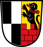
| Blazon : “Split; front quartered in black and silver; in the back in gold over a red battlement wall a growing, red reinforced black bracke with a red collar, on it the inscription GEFREES. " | |
Culture and sights
Architectural monuments
Regular events
From the Thursday before the second Sunday in July until the Monday after that, the popular festival and meadow festival takes place every year.
Economy and Infrastructure
traffic
The federal highway 2 leads through the middle of the city, it is the diversion for the parallel federal highway 9 with the junction 37 Gefrees , both cross the community area in north-south direction.
The station Gefrees was at the falls-gefrees railway . Passenger traffic ceased on September 30, 1973. On December 31, 1993 the line was closed .
The nearest train stations are Marktschorgast , Stammbach and Münchberg on the Bamberg – Hof railway line , they are all above the Inclined Plane on the course book route 850.
Established businesses
Gefrees is shaped by the textile industry. A business division of Helsa Group International that started developing cabin air filters at the end of the 1980s was sold to a financial investor in 2004 and has since operated under the name of helsa-automotive GmbH & Co. KG . In 2008, helsa-automotive was taken over by the Ludwigsburg automotive supplier MANN + HUMMEL GMBH. The machine factory and iron foundry Herold & Co. GmbH manufactures rotary lobe pumps for the sugar , food and chemical industries. The company Müller Stanz- u. Umformtechnik GmbH & Co. KG was a global manufacturer of presses .
Public facilities
- City hall with indoor swimming pool, bowling alley, shooting range, hall for sports and meetings and conference rooms and restaurant
education
- Primary and secondary school Gefrees
- Jacobsen Ellrod -School, evangelical full-time real school , founded in 1967
Personalities
sons and daughters of the town
- Ernst Duschön (1904–1981), politician ( NSDAP )
Personalities who have worked in the city
- Heinrich Christian Funck (1771–1839), pharmacist and botanist
literature
- Johann Kaspar Bundschuh : Gefrees . In: Geographical Statistical-Topographical Lexicon of Franconia . tape 2 : El-H . Verlag der Stettinische Buchhandlung, Ulm 1800, DNB 790364298 , OCLC 833753081 , Sp. 286 ( digitized version ).
- District of Münchberg (Ed.): Resident and business handbook of the district of Münchberg . Grau, Hof (Saale) 1950.
- Georg Paul Hönn : Gefreeß . In: Lexicon Topographicum of the Franconian Craises . Johann Georg Lochner, Frankfurt and Leipzig 1747, p. 250 ( digitized version ).
- Pleikard Joseph Stumpf : Gefrees . In: Bavaria: a geographical-statistical-historical handbook of the kingdom; for the Bavarian people . Second part. Munich 1853, p. 569-570 ( digitized ).
Web links
Individual evidence
- ↑ "Data 2" sheet, Statistical Report A1200C 202041 Population of the municipalities, districts and administrative districts 1st quarter 2020 (population based on the 2011 census) ( help ).
- ^ Community Gefrees in the local database of the Bavarian State Library Online . Bayerische Staatsbibliothek, accessed on January 5, 2020.
- ↑ a b c d Harald Judas: The road brought life and death in: Nordbayerischer Kurier from January 18, 2016, p. 19
- ↑ Sold by Napoleon in: Nordbayerischer Kurier of January 13, 2016, p. 12
- ↑ Gefreeser story in four images in: North Kurier of 22 February 2016 p 20
- ^ Announcement on the dissolution of the Berneck District Office from September 21, 1929
- ^ City history Gefrees on fichtelgebirge.Bayern-online.de
- ↑ http://www.autobahn-online.de/altefreigaben.html
- ^ Wilhelm Volkert (ed.): Handbook of Bavarian offices, communities and courts 1799–1980 . CH Beck, Munich 1983, ISBN 3-406-09669-7 , p. 434 .
- ^ Wilhelm Volkert (ed.): Handbook of Bavarian offices, communities and courts 1799–1980 . CH Beck, Munich 1983, ISBN 3-406-09669-7 , p. 576 .
- ^ Federal Statistical Office (ed.): Historical municipality directory for the Federal Republic of Germany. Name, border and key number changes in municipalities, counties and administrative districts from May 27, 1970 to December 31, 1982 . W. Kohlhammer, Stuttgart / Mainz 1983, ISBN 3-17-003263-1 , p. 675 and 676 .
- ↑ Life in Gefrees. Gefrees City Council, accessed on July 18, 2020 .
- ^ Entry on the Gefrees coat of arms in the database of the House of Bavarian History
- ↑ History of the Herold & Co. GmbH company
- ↑ Global group SKF awards the highest award to Herold in Gefrees


