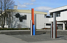
Hollfeld
| coat of arms | Germany map | |
|---|---|---|
|
Coordinates: 49 ° 56 ' N , 11 ° 17' E |
|
| Basic data | ||
| State : | Bavaria | |
| Administrative region : | Upper Franconia | |
| County : | Bayreuth | |
| Management Community : | Hollfeld | |
| Height : | 403 m above sea level NHN | |
| Area : | 80.66 km 2 | |
| Residents: | 5050 (Dec. 31, 2019) | |
| Population density : | 63 inhabitants per km 2 | |
| Postal code : | 96142 | |
| Area code : | 09274 | |
| License plate : | BT, EBS , ESB , KEM , MÜB , PEG | |
| Community key : | 09 4 72 154 | |
| LOCODE : | DE HL4 | |
| City structure: | 24 districts | |
City administration address : |
Marienplatz 18 96142 Hollfeld |
|
| Website : | ||
| Mayor : | Hartmut Stern ( Citizens' Forum ) | |
| Location of the city of Hollfeld in the Bayreuth district | ||
Hollfeld is a town in the Upper Franconian district of Bayreuth , a state-approved resort and the seat of the Hollfeld administrative community .
geography
Geographical location

The officially recognized resort of Hollfeld is 25 kilometers west of Bayreuth and 35 kilometers east of Bamberg in the northern part of Franconian Switzerland at the confluence of the Wiesent and Kainach rivers .
The area of the city lies in the west of the Bayreuth district and borders on the Bamberg , Lichtenfels and Kulmbach districts .
City structure
The city has 24 districts :

|

|

|

|

|

|

|

|
| Drosendorf | Fernreuth | Freienfels | Gottelhof | Hainbach | Yards | Hollfeld (main town) | Kainach |

|

|

|

|

|

|
||
| Krögelstein | hole | Moggendorf | Neidenstein | Pilgrim village | Sheep farm | Schnackenwohr | Schönfeld |

|

|

|

|

|

|

|
|
| Stechendorf | Tiefenlesau | Treppendorf | Utzbuerg | Pond | Withered village | Wiesentfels | Residential village |
Neighboring communities
Neighboring communities are (starting from the north clockwise): Wonsees , Thurnau , Mistelgau , Plankenfels , Aufseß , Königsfeld , Stadelhofen and Weismain .
history
Before and early settlement
The castle and settlement core of Hollfeld is documented in prehistoric times. On the Hohe Knock, in the area of the Loch district to the northeast of Hollfeld, there was a small prehistoric fortification on a hill above a rock cave, which gave the Loch district its name. Wall remains are still recognizable. There are from different time layers various objects, including a Latène lens bottle, a razor from the early Roman period (1st century), a bronze tube sleeve from the late Roman period (about 350 ) and some arrowheads, probably the late imperial period, or early migration period (4th / 5th century) are to be assigned. Finds in Wiesentfels also indicate a fortification from the Migration Period .
First mention
Hollfeld looks back on more than a thousand years of history. It was first mentioned in a document in 1017, when the Bishop of Würzburg ceded the church tithes of the villages that once belonged to Hollfeld to the Bamberg Bishop.
Hollfeld still has the settlement structure of a spur settlement , which suggests a core settlement in the style of the margraves of Schweinfurt . Representatives of these margraves were the Walpoten family. After the margrave family died out in 1057, Reginolt Walpoto gave away his goods in Hollfeld and the surrounding area in 1059 to equip the St. Gangolf Abbey in Bamberg, which he co-founded .
City elevation
The reason for the founding of a town with a castle character was probably the rivalry with the Andechs-Meranians who owned properties in the surrounding area. There is no precise evidence of Hollfeld's elevation to the rank of town. After all, it was referred to as a city in an external document in 1285. The first exact proof of the city's property, the seal stamp with the inscription “S. CIVITATIS IN HOLVVELT “, dates back to 1329.
Destruction
Hollfeld played an important role as a border fortress between the bishopric of Bamberg and the Markgraftum Kulmbach-Bayreuth , but it was also destroyed several times by wars and fires. These include the devastation caused by the Hussites in 1430, the Margrave War 1552/53 and the Thirty Years War. In 1630/31 the city was devastated and in 1634 the black plague raged so violently that only 14 married couples remained. In 1724 the city was destroyed by another devastating city fire.
Belonging to Bavaria
A Vogt of St. Gangolf administered the Hollfeld Propstei until the end of the Bamberg Monastery . Since the Reichsdeputationshauptschluss of 1803, the place, like large parts of Franconia, has belonged to Bavaria (see also History of Franconia ).
Napoléon Bonaparte went to the Russian campaign via Hollfeld . During the wars of liberation against Napoleon between 1812 and 1815, around 8,000 Russian soldiers are said to have been billeted in the area around Hollfeld.
Hollfeld municipality
The municipality was created in the course of the administrative reforms in Bavaria with the municipal edict of 1818 . From 1862 on, Hollfeld was a district municipality with 89 places before it was combined with Ebermannstadt in 1919 to form a district office. As part of the regional reform , the incorporation of eight municipalities resulted in the formation of a large municipality in several steps. On July 1, 1971, part of the former municipality of Drosendorf an der Aufseß was incorporated. On January 1, 1972, Freienfels, Schönfeld, Stechendorf, Treppendorf, Weiher and Wiesentfels followed. Kainach joined on July 1, 1972. At the same time, Hollfeld was assigned to the Bayreuth district. On May 1, 1978, Krögelstein and parts of the dissolved community of Hochstahl were incorporated.
Madonna robbery
In 1962, the city of Hollfeld reached the national media. The famous Riemenschneider Madonna from Volkach was stolen from the pilgrimage church Maria im Weingarten on August 7, 1962 during a spectacular robbery and buried by the thieves in Hollfeld near the so-called Badersleite. Prepared with a protective layer of shoe polish and floor wax, the work of art remained underground until it was triggered. In October 1962, the Stern publisher, Henri Nannen, managed to surrender the valuable stolen property for a ransom of DM 100,000.
Old street and field names
Origin of the place name
Hollfeld was called Holevelt in the Middle Ages . The word field originally meant territory or property and is also often used in the names of neighboring towns (e.g. Königsfeld, Steinfeld, Waischenfeld and Schönfeld). In the Erbachtal there is the Alten-Hollfeld desert.
Behind Hole is probably the Slavic word gola (g = h), which meant vacant, forest-free area.
Field names
The field name Heide occurs everywhere in the Hollfelder Flur (to the west the Äußere Heide, to the south the Green Heide, outside the White Heide, northeast the Bergheide). There is also the Upper and Lower Goll in the area of the Kleine Heide. Heide often referred to border locations and a forest-free area between two settlement zones.
Street names
Street names in the town of Hollfeld such as Am Graben or Am Wallberg refer to old fortifications. The Bahnhofstrasse is an indication that Hollfeld had a rail connection until 1974. The Judengasse commemorates the Jews who used to live there. The street name Turkey in the lower town comes from the 17th century, when Ottoman prisoners of war were abducted to Hollfeld. They were mostly baptized and later assimilated. From these residents it is mentioned, for example, that a “prince from Arabia received an alms” and in a record book from 1764 there is talk of a “Dukish music”.
chronology
- October 24, 1017 First documented mention
- 1329 mention of the oppidum holuelt as a city
- 1348 name castrum as an episcopal state castle
- 1419 mentioned as an important road junction
- 1417–1432 Mention of properties around and in Hollfeld in the Liber freudalis ecclesiae St. Gangolphi , the loan book of the St. Gangolf monastery in Bamberg
- 1430 pillage in the Hussite War
- 1553 and 1554: pillage in the Markgräflerkrieg
- 1632 pillage by the Swedes in the Thirty Years' War
- 1634 plague epidemic
- 1724 Big city fire
- 1804 District Court Hollfeld
- 1812 Emperor Napoleon I goes to the Russian campaign via Hollfeld , billeting of soldiers until 1823
- 1877 Establishment of the local court
- 1904 Inauguration of the Bayreuth-Hollfeld railway
- 1945 City pastor Kurt Weirather saves the city from destruction by American soldiers
- 1964 Dissolution of the local court
- 1971 Establishment of the comprehensive school
- 1972 Dissolution of the Ebermannstadt district and incorporation of Hollfeld into the Bayreuth district
Population development
In the period from 1988 to 2018, the population stagnated: The official population on December 31, 2018 was 5043, only one lower than 30 years earlier. A peak was reached on December 31, 2000 with 5352 inhabitants.
politics
City council
The city council has 20 members. The local elections on March 2, 2008 and March 16, 2014 resulted in the following results:
| Party / list | 2008 | 2014 | ||
| CSU | 7 seats | (32.0%) | 6 seats | (28.8%) |
| SPD | 2 seats | (9.3%) | - | - |
| Greens / Independent | - | - | 1 seat | (6.3%) |
| Hollfeld-Land electoral community | 4 seats | (21.0%) | 6 seats | (27.5%) |
| BürgerForum City and Country | 5 seats | (24.7%) | 4 seats | (22.0%) |
| Citizens' Community of Free Voters | 1 seat | (7.8%) | 1 seat | (7.1%) |
| Home list | 1 seat | (5.3%) | 2 seats | (8.4%) |
| voter turnout | 77.2% | 67.3% | ||
Another member and chairman of the city council is the mayor.
mayor
Hartmut Stern (Citizens Forum) has been mayor since 2020. Its predecessor was Karin Barwisch (Citizens' Forum) since May 2002.
Coat of arms, flag
|
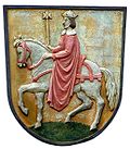
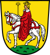
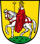
Blazon : "In gold on a green arched foot (ground) a striding, red-bridled silver steed with raised left front hoof, on it a silver rider dressed in a long, red coat with a silver collar with golden hair, a golden crown on the head and a golden lily scepter in carrying the right. "
Declaration of coat of arms: The rider is interpreted as Emperor Heinrich II , who founded the Bamberg diocese in 1007, to which Hollfeld belongs. The colors of the coat of arms are already handed down in the Bamberg vassal table from 1603. The coat of arms has been in use since the 14th century and is documented by a seal around 1350. This city seal had the inscription “S. CIVITATIS IN HOLVVELT ”. In a seal from 1554 the emperor rides to the left, but the flag is missing. At the beginning of the 18th century, the rider is shown for the first time in a shield. In the mayor's medal from 1819, the rider is pointed to the right again. |
|
The city flag has the colors yellow-red-white (gold-red-silver).
Intermunicipal cooperation
The city of Hollfeld has been a member of the association for regional development “Around the Neubürg - Franconian Switzerland e. V. "
religion
The origins of the first Hollfeld parish probably go back to the time before the founding of the Bamberg diocese . A parish was first mentioned in a document in 1017. After splitting off from the original parish of Königsfeld in 1168, Hollfeld developed into a mother parish for numerous new foundations. As one of the four Bamberg archdeaconates , Hollfeld was of great importance to the diocese in the Middle Ages.
Catholics
The population of Hollfeld is predominantly Catholic. The city church of the Assumption of Mary is the center of the parish association of St. Salvator Hollfelder Land, which belongs to the Bayreuth deanery .
Protestants
The Friedenskirche is the city church of the Evangelical Lutheran community of Hollfeld and belongs to the Thurnau deanery of the Bayreuth church district . The parish has been running the WIGWAM Familienzentrum e. V.
Culture and sights
Buildings
The historic old town has been almost completely preserved from an early medieval castle, the Hollfeld town castle . The Gangolf Church, the renovated old town hall, the Wittauerhaus, the parish church of the Assumption of Mary, the fish mill from 1715, the pilgrimage church of St. Salvator, the museum barn and the art museum are all worth seeing.
See also: List of architectural monuments in Hollfeld
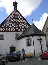
Bartholomäusspital
The chapel of the hospital founded in 1464 by Regensburg canon Werner von Aufseß was built in 1709. Inside there is a baroque group of crosses, a Gothic Madonna and a sculpture of St. Otto .
The Bartholomäusspital was donated by Werner von Aufseß for sick and poor people. At that time it was still outside the city wall. The chapel was added to the building, which was built in 1664, in 1709. In 1839, the mayor of Hollfeld, Lorenz Schmötzer, chose the hospital as the main heir and decreed that people with good repute, poor, old or not settled should be accepted there.
After the First World War, refugees were quartered in the building. From 1935 to 1978 it was used as a kindergarten. During the renovation of the old people's home, the residents were housed in the hospital and after a renovation in 1978 the largest room served as a meeting room for the city council. The tourist office was also temporarily housed there.
The Bartholomäusspital is no longer used and cannot be visited.
Blue tower
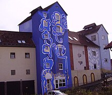
The so-called Blue Tower or the “Hollfeld Idea House” is a residential building with a museum and artist's studio (back side), which was designed in 2005/06 from a raw brick building of the White Taube Brewery by the Eckersdorf artist Thomas Brix . During the work, the idea arose to illuminate the building at night, with the stucco decorations shining in gold and silver. The illumination was carried out by lighting designers from the Coburg University of Applied Sciences .
Museum barn
The Franconian Switzerland museum barn is housed in a building in the Judengasse (Upper Town) that was renovated in 1993 and shows exhibits from the town's history as well as evidence of rural working culture and old craft traditions. Plows, harrows, flails, products from wagons , saddleries , pottery, etc. are on display . The museum barn also houses a swarm of bees that can be observed through a pane of glass. Farmer's bread is baked once a month .
Idea house
The House of Ideas (Art & Museum) is housed in the spacious building of a former brewery (back of the Blue Tower) on the edge of the old town, Eiergasse 13. In addition to a gallery and Axel Luther's artist studio, these rooms also contain a tailor's workshop, a barber shop and a dental practice from the 1920s, as well as a collection of old skis.
Churches
Assumption Day
The early classicistic parish church of the Assumption of Mary received its baroque interior from the secularized Dominican church in Bamberg . It has been destroyed several times over the centuries. After the great fire of the city in 1724 it was renovated, but its condition deteriorated more and more, so that in 1777 a new building was decided, which was completed in 1781.
Originally Fritz Ignaz Michael Neumann, the son of Balthasar Neumann , was supposed to carry out the new building, but the Hollfeld town council refused to approve and transferred it to the Bamberg master builder Johann Josef Vogel. Although the church was given its intended purpose as early as 1781, the solemn consecration did not take place until 1826.
The main portal is flanked by larger than life statues of the Bamberg diocese saints Heinrich and Kunigunde. Inside, the lavishly furnished main altar and the four side altars are particularly striking.
Gangolf Church
The Gangolf Church stands at the highest point in the city of Hollfeld. It goes back to the Bamberg Gangolf Church , whose feudal people sat on monasteries in the lower and upper town of Hollfeld.
The legend of the little bells was told about this church :
At a time when the area around Hollfeld was still surrounded by dense forest, the lord's three daughters went on a trip to the Kainach and got deeper and deeper into the forest. They were caught by a thunderstorm and huddled together in fear. When the thunderstorm cleared, they found that they were lost. Night fell and as they prayed desperately, they heard a bell. They followed the sound and met their father, who had gone out with servants to look for them. Out of gratitude for the salvation of his children, he donated a bell for the tower of the Gangolf Church, which was later referred to by the people as the “Irrglöckchen” and was supposed to lead stray hikers back on their way. For this reason, the little bell from Sankt Gangolf rings every evening at 9:45 p.m. A newspaper report from 1937 tells of the city tower's activity:
“The duties of the tower guard also included participating in all musical services, arranging church music, adjusting the tower clock every day, giving signals in the event of a conflagration, and ringing prayers three times a day. He also had to play a few pieces on the tower with several people on Sundays and public holidays. If he discovered Feuerschein outside the city in the Hollfeld district, he had to shoot twice with the double hook attached to the tower. The evening prayer is known to be traced back to the legend of the three lost virgins; for this the tower keeper receives 10.80 M annually, which is 4.20 M less than the previous tower keeper Rößner received. The ringing times are set at 5 a.m., 7 a.m., 12 noon, 8 a.m. in the evening and 10 a.m. at night. "
The medieval fortification tower is Hollfeld's landmark. It is 38 meters high and has 98 steps. The last tower keeper died on December 30, 1971 at the age of 61 in the tower keeper's apartment, after having served there for over 20 years. The tower keeper's apartment has been empty since then. Until the renovation of the tower in 1975, the bell was not rung either. Only the installation of an electrical bell system made it possible to revive the ringing of the little bells. The St. Gangolf Art and Culture Center is located in the building.
Salvator Church
The history of the Hollfelder Salvatorkirche goes back to the early Middle Ages. At that time the place still belonged to the original parish of Königsfeld and the diocese of Würzburg . Hollfeld's own parish was founded in 1007. Today's pilgrimage church was built in 1704 under the architect Leonhard Dientzenhofer .
Legend has it that a wandering Slav, hungry and thirsty, rested under an oak tree that stood on the site of today's church. He heard happy music from the town because Hollfeld was just celebrating a church fair. The happiness of the city and his own poverty touched his heart so much that he complained about his fate. Then Christ appeared to him with a cross and a crown of thorns and said to him:
- “You complain about your cross and think it's difficult. Please refer! It is because of you that I have been carrying my cross for a long time. Wear yours with patience, because I will soon take you home. "
With these words, the apparition disappeared and the man found that it was Christ himself. He rushed into town and told what he had experienced. Pious people built a chapel on the square and the news of many answers to prayer spread, so that many pilgrims soon made pilgrimages to this church. The pilgrimage to the Hollfelder Salvatorkirche (Latin: Salvator = redeemer ) is the only Salvator pilgrimage in the Archdiocese of Bamberg today .
Historical old city
The heart of the historic old town is Marienplatz on a hill above the city. The Baroque Nepomuk Chapel from 1734 stands in front of the Upper Gate.
In past centuries, livestock markets and annual fairs were held on the market square, Marienplatz. Today a farmers market, the palm market, the autumn market and the Christmas market take place here.
In the middle of Marienplatz there is a 38 meter deep draw well, which was mentioned as early as 1435. According to legend, this well was dug by prisoners of war. The well was filled in in the 17th century and only opened again in 1856, but soon afterwards it was bricked up again. It was only rebuilt in its current form in 1936.
Terraced gardens
The terrace gardens are a garden on the steep southern slopes of the old town with rare plants, including several native orchid species . The Hollfeld Rose Art & Garden Days are held there in summer .
Cultural institutions
movie theater
The Kintopp movie theater Hollfeld is the only cinema in the Franconian Switzerland. It was operated by the former film journalist Ursula Scheicher until the end of 2011. An entrepreneur from Neuhaus took over the Kintopp for the next two years. The non-profit association Kintopp Freunde Hollfeld e. V. Operator of the cinema.
Franconian theater summer
In 1994 the sculptor Wolfgang Pietschmann and the actor Jan Burdinski founded a traveling open-air theater in Hollfeld with the aim of bringing theater culture to the country during the summer months. The focus should be on musical and literary programs, cabaret, children's theater and, in particular, European comedy. After two successful seasons, the non-profit association Theatersommer Fränkische Schweiz e. V. was launched. The town of Hollfeld was designated as the seat of the association and thus the theater.
Over the years, the theater summer has expanded the number of venues and the content of the program considerably. Every year between 170 and 220 events take place in over 75 locations. Franconian Switzerland is still the core area of the performances, but the ensemble is now also playing in Central and Lower Franconia and in the Upper Palatinate. Castell, Neumarkt in der Oberpfalz, Marktredwitz, Hof, Schwarzenbach and Rödental are the furthest destinations of the Thespis-Karrens. In 2007 the association changed its name to Fränkischer Theatersommer e. V. and officially became the Upper Franconian State Theater. The Franconian theater summer has a varied and demanding cultural offer in rural areas, with drama, comedy, chamber theater, music, cabaret, culinary theater, children's theater and theater education.
societies
- The largest sports club is ASV Hollfeld, whose first soccer team made it through from the district class to the Bayernliga Nord.
- There is also the SC comprehensive school, whose 400 members mainly practice basketball, volleyball and Nordic walking.
Other sports clubs are:
- 1960 Hollfeld chess club
- Hollfeld tennis club
- Rifle Society from 1891
In the cultural field, the Hollfeld youth brass band stood out and successfully took part in national competitions.
Economy and Infrastructure

In addition to the usual basic services, there are several bus companies and a cinema. The C. Bange publishing house , which is known nationwide (especially in schools) for the publication of the small translation library of Roman and Greek classics , and the Futterfreund GmbH have their headquarters there
Hollfeld comprehensive school
The Hollfeld State Comprehensive School (GSH) is a “special kind of school” (BayEUG) and one of a total of four comprehensive schools in the state of Bavaria. The other Bavarian comprehensive schools are in Treuchtlingen, Munich and Nuremberg . The students of the Hollfeld comprehensive school come from a catchment area of a little more than twenty kilometers around the city of Hollfeld. There are the following degree options:
- Secondary school leaving certificate
- Qualifying secondary school diploma
- Middle school leaving certificate
- High School
In grades 5 and 6, the pupils are not yet divided into school types. Only from grade 7 onwards are they assigned to the Hauptschule, Realschule or Gymnasial train. In the 2011/2012 school year, around 1160 students attended the Hollfeld State Comprehensive School.
traffic
Rail transport
From 1904 to 1974 Hollfeld was the terminus of the Bayreuth – Hollfeld railway line . A planned train connection between Scheßlitz and Hollfeld was discontinued in 1906 after extensive preparatory work, as both places failed the project for political reasons. The reason, however, was not the high construction costs (two million marks), but that both cities preferred the lucrative status of terminal stations.
Four of the discussed options for leading a railway line to the Franconian Jura were:
- via Würgau and Königsfeld (construction costs 1.89 million marks)
- through the Burglesau valley via Steinfeld and Königsfeld (2.125 million marks)
- from Memmelsdorf via Litzendorf , Tiefenellern and Königsfeld (2.170 million marks)
- from Gundelsheim via Melkendorf , Herzogenreuth and Königsfeld (construction costs 2.77 million marks)
The line preferred by the planners would have run from Scheßlitz in the direction of Würgau , then would have led up to the Schlappenreuther Berg in the Jura. The train would then have passed through the Burglesau valley via Graefenhäusling to Steinfeld , before finally reaching the town of Hollfeld via the valleys of Wiesent and Aufseß via Königsfeld .
After 1918, efforts to build the Jura Railway were resumed. But in 1920 the Reich Ministry of Transport announced that in view of the poor economic situation, the construction of new railway lines had to be avoided for the time being. In 1930 a post bus line was finally opened from Bamberg via Scheßlitz and Hollfeld to Bayreuth.
Road traffic
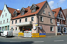
Hollfeld is located on the busy Bundesstraße 22 , which leads from Würzburg via Bamberg and Bayreuth to Cham in the Upper Palatinate.
The distance to the next motorway exit ( A 70 Bayreuth-Schweinfurt) is ten kilometers. The nearest airport, Nuremberg, is 90 kilometers away. The port of Bamberg is 35 kilometers away. Hollfeld is 25 kilometers away from the district town of Bayreuth .
Hiking trails
The Franconian Marienweg runs through Hollfeld .
Water supply
The Hollfelder Mulde has a groundwater thickness of up to 150 meters and is drained via Aufseß and Wiesent. It has a catchment area of around 200 square kilometers and an estimated water content of one billion cubic meters, of which around one million are currently (2007) used each year.
Personalities
Born here
- Johannes V. Dressel († 1637), abbot of the Cistercian monastery in Ebrach
- Clemens Adams (1891–1962), politician
Honorary citizen
- Elmar Maria Kredel (1922–2008), Archbishop of the Archdiocese of Bamberg from 1977 to 1994
literature
- Johann Kaspar Bundschuh : Hollfeld . In: Geographical Statistical-Topographical Lexicon of Franconia . tape 2 : El-H . Verlag der Stettinische Buchhandlung, Ulm 1800, DNB 790364298 , OCLC 833753081 , Sp. 749-750 ( digitized version ).
- Pleikard Joseph Stumpf : Hollfeld . In: Bavaria: a geographical-statistical-historical handbook of the kingdom; for the Bavarian people . Second part. Munich 1853, p. 596 ( digitized version ).
- Pleikard Joseph Stumpf : Krögelstein . In: Bavaria: a geographical-statistical-historical handbook of the kingdom; for the Bavarian people . Second part. Munich 1853, p. 598 ( digitized version ).
Web links
Individual evidence
- ↑ "Data 2" sheet, Statistical Report A1200C 202041 Population of the municipalities, districts and administrative districts 1st quarter 2020 (population based on the 2011 census) ( help ).
- ^ Hollfeld municipality in the local database of the Bavarian State Library Online . Bayerische Staatsbibliothek, accessed on January 5, 2020.
- ↑ News from archeology - A fortification near Loch, City of Hollfeld. (Landscape Museum Obermain Plassenburg)
- ↑ Johannes Neumann: The Reichsdeputationshauptschluss of 1803: Requirements and consequences (PDF file; 179 kB)
- ^ Wilhelm Volkert (ed.): Handbook of Bavarian offices, communities and courts 1799–1980 . CH Beck, Munich 1983, ISBN 3-406-09669-7 , p. 452 .
- ^ Federal Statistical Office (ed.): Historical municipality directory for the Federal Republic of Germany. Name, border and key number changes in municipalities, counties and administrative districts from May 27, 1970 to December 31, 1982 . W. Kohlhammer, Stuttgart / Mainz 1983, ISBN 3-17-003263-1 , p. 676 .
- ^ Egert, Gerhard: Henri Nannen and the Volkacher Kunstraub 1962 . P. 176.
- ↑ https://www.domradio.de/nachrichten/2012-08-06/vor-50-jahren-wurde-riemenschneiders-rosenkranz-madonna-gestohlen
- ↑ The Mayor. Hollfeld municipality, accessed on August 22, 2020 .
- ↑ elections Bavaria. Retrieved March 7, 2017 .
- ^ Entry on Hollfeld's coat of arms in the database of the House of Bavarian History
- ↑ About us - The Neubürg at a glance - Neubürg. Accessed June 8, 2020 (German).
- ↑ Archive link ( Memento of the original from March 4, 2007 in the Internet Archive ) Info: The archive link was inserted automatically and has not yet been checked. Please check the original and archive link according to the instructions and then remove this notice. The little wacky bell from St. Gangolf zu Hollfeld
- ↑ Archive link ( Memento of the original from March 4, 2007 in the Internet Archive ) Info: The archive link was inserted automatically and has not yet been checked. Please check the original and archive link according to the instructions and then remove this notice. 1
- ↑ Summer theater
- ↑ http://www.futterfreund.de/ The Futterfreund GmbH have their headquarters on site.


