
Weismain
| coat of arms | Germany map | |
|---|---|---|

|
Coordinates: 50 ° 5 ' N , 11 ° 14' E |
|
| Basic data | ||
| State : | Bavaria | |
| Administrative region : | Upper Franconia | |
| County : | Lichtenfels | |
| Height : | 316 m above sea level NHN | |
| Area : | 90.15 km 2 | |
| Residents: | 4751 (Dec. 31, 2019) | |
| Population density : | 53 inhabitants per km 2 | |
| Postal code : | 96260 | |
| Primaries : | 09575, 09576, 09220, 09504 | |
| License plate : | LIF, STE | |
| Community key : | 09 4 78 176 | |
| LOCODE : | DE WM9 | |
| City structure: | 35 districts | |
City administration address : |
Am Markt 19 96260 Weismain |
|
| Website : | ||
| Mayor : | Michael Zapf (GUB) | |
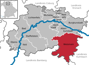
| Location of the city of Weismain in the Lichtenfels district | ||
  |
||


Weismain is a town in the Upper Franconian district of Lichtenfels in the north of the Free State of Bavaria .
geography
Geographical location
The state-approved resort (since 1976) Weismain is located on the northern edge of the Franconian Switzerland-Veldenstein Forest Nature Park . It is traversed by the river of the same name, the Weismain . The lowest point in the city is 295 m above sea level. NN , the highest at 547 m above sea level. NN .
City structure
The 37 districts of Weismain with population figures (as of January 1, 2012) are:
![]() Map with all coordinates: OSM | WikiMap
Map with all coordinates: OSM | WikiMap
history

Until the 19th century
An early medieval cemetery from the 8th and 9th centuries was discovered in 1972 north-west of the town center on the corner of Gruenköttendorfer Straße-Bürgermeister-Kraus-Straße. It contained 209 graves, some of which were valuable, which indicates the relative wealth of the inhabitants at the time. A wooden house of the dead and a grave with a circular moat indicate a hill. There were such grave mounds sporadically in southern Germany around 700. They are sometimes seen as pagan countercurrents to the spreading Christian faith. Weapons were found in some graves, including two Spatha swords . Arms additions are typical for the period up to the 7th century and it cannot be ruled out that the use of the cemetery began during this time.
Weismain was first mentioned in 800 in a document from the Fulda monastery . In the Thirty Years' War , according to a legend, the Swedish besiegers were driven out by a small unit consisting mainly of peasants moving from Niesten Castle towards Weismain and using tools and other equipment to make such noise that the Swedes feared the imperial troops were approaching. A Swedish procession is held annually to commemorate the Assumption of Mary .
In 1840 the population of Weismain was 1264.
Incorporations
On January 1, 1976, the previously independent communities Modschiedel with the places Modschiedel , Wunkendorf and Wohnsig and Wallersberg with the places Wallersberg, Mosenberg, Frankenberg and Schammendorf were incorporated. On July 1, 1976, Kaspauer with Altendorf, Kaspauer and Siedamsdorf were added. Arnstein , Großziegenfeld and Weiden followed on January 1, 1977. The series of incorporations ended with the incorporation of Buckendorf, Fesselsdorf and Kleinziegenfeld as well as large parts of Neudorf with Neudorf, Seubersdorf, Krassach, Niesten and Görau on January 1, 1978; on the same day Zultenberg came to Kasendorf .
Population development
In the period from 1988 to 2018, the city grew from 4598 to 4783 by 185 inhabitants or 4%. On December 31, 1996, Weismain had 5085 inhabitants.
politics
City council
After the local elections on March 15, 2020 , the city council will be composed as follows:

| Party / list | Share of votes | Seats 2020 | Seats 2014 |
|---|---|---|---|
| CSU | 39.1% | 6th | 8th |
| SPD | 11.0% | 2 | 2 |
| Green | 5.8% | 1 | 1 |
| GUB / FW * | 30.7% | 5 | 3 |
| Weismain Citizens' Block (BB) | 11.0% | 2 | 2 |
| AfD | 2.4% | 0 | - |
| total | 100% | 16 | 16 |
| voter turnout | 74.3% | ||
* Community of Independent Citizens / Free Voters
In addition, the mayor is a member of the municipal council.
mayor
- 1899–1920: Heinrich Rothlauf (1851–1930)
- 1920 / 22-1933: Adam Hatzold (1874–31 December 1945)
- 1933–1937: Julius Erhard (1881 / 82–1950)
- 1938–1944: Luitpold Agatz
- April 1945–31. December 1945: Adam Hatzold (1874–31 December 1945)
- 1946–1947: Adam Schreiber (1900–1949)
- offic. 1959: Heinrich Raab (1886–1962)
- 1960–1972: Bernhard Stölzle, first CSU, left 1971 (1921 / 22–18 July 2014)
- 1972–1996: Max Goller (1929–11 December 1996), first BB, then CSU; full-time since 1976 (mayor's office is no longer an honorary position)
- 1996–2008: Peter Riedel, SPD
- 2008–2020: Udo Dauer, CSU
- since 2020: Michael Zapf, GUB
Town twinning
-
 France : Since 2006 there is a twinning between Weismain and the French community Quéven in Brittany.
 -
 Germany : Weismain and Borgfeld , a district of the Free Hanseatic City of Bremen, have been twinned since 2011 .
Culture and sights
Weismain is located on the German Toy Road , the Franconian Beer Road and the Castle Road . In the district of Giechkröttendorf there is a castle from the 16th century.

Weismain city center
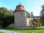
Defense tower with city wall and parish church in the background
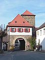
The only remaining southern city gate, the Upper Gate
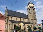
Late Gothic parish church of St. Martin , 15th century

Weihersmühle in the Kleinziegenfelder valley
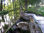
Autumn idyll near the water playground on the Weismain


Architectural monuments
Museums
- North Jura Museum in Kastenhof
- On May 14, 2004, the NordJURA Museum was opened in the historical rooms in Kastenhof, a building constructed between 1701 and 1703 according to plans by Leonhard Dientzenhofer . The 600 m² exhibition focuses on the emergence of the Jura landscape, the ability to defend itself, the Thirty Years War, denominational fragmentation and the economic sectors (breweries, sheep, use of water for mills, fishing and textile crafts) in this region. There are special exhibitions several times a year.
Established businesses
- Püls-Bräu brewery (since 1798)
- Baur Versand GmbH & Co KG (with administration building and parts of the logistics)
- I'm walking shoe shipping
- dhib Dechant civil engineering (founded in 1881)
- Dietz Baugesellschaft (founded October 16, 1878)
- Gerber Kunststofftechnik (founded September 1945)
Former companies
- Obendorfer Brewery (1852–1997)
- Fuchs Brewery (1874–1969)
- Dietz Brewery (1896–1983)
- Sausage factory J. & A. Kraus (1889–1974), processed 3 million kg of meat in 1957 and exported to France and Great Britain, employed 400 people in the 1960s
- Clothing factory Josef Rebhan (1945–1988), employed 120 people in 1961
Sports
The soccer club SC Weismain belonged to the regional soccer league from 1996 to 1999 , at that time the third highest division. Weismain played in the Waldstadion Weismain , which after several extensions until the mid-1990s initially offered 10,000 seats. A capacity of 10,000 was not enough, however, because the game of the games in the Regionalliga-Süd was approaching from Weismain's point of view: 1. FC Nürnberg came. For example, a further 18 rows of sandstone blanks were connected to the nine concrete standing steps on the east side and a floodlight system was installed. On April 12, 1997, the "Club" started in the 5000-inhabitant community, in which a sensational 17,000 spectators were counted at the "Franconian Football Festival". The game was lost 2-0 to the later promoted team from Nuremberg , but “Weismain became a synonym for Regionalliga for the clubbers . Telling people you've been there still gives you a certain prestige in fan circles today ”. In the 2008/09 season , 1. FC Eintracht Bamberg played its home games in the 17,000-seat Waldstadion because the stadium in Bamberg did not meet the DFB criteria.
City personalities
sons and daughters of the town

- Friedrich Förner (1568–1630), auxiliary bishop, vicar general in Bamberg , under Johann Georg II. Fuchs von Dornheim , called the witch burner
- Abbot Mauritius Knauer (1613 / 1614–1664), the author of the centenary calendar
- Joachim Kügler (* 1958), Roman Catholic theologian
- Paul Joseph Metschnabl (1910–1996), cathedral music director at Bamberg Cathedral
- Georg Thomas Rudhart (1792–1860), historian and archivist
- Ignaz von Rudhart (1790–1838), Prime Minister of Greece
Honorary citizen
- Michael Dechant (1909–1985), awarded 1983
- Fritz Dietz (* 1937), former mayor
- Alois Dechant (* 1940), awarded December 16, 2010
- Erhard Meissner (born April 9, 1932 in Oberadersbach; † March 29, 2014 in Modschiedel), pastor of the Modschiedel parish (1976–2007), parish administrator of the Arnstein parish (1979–2003). He was awarded honorary citizenship in 2007 for his services to the preservation of religious life and the maintenance and renovation of churches and chapels in his parishes.
literature
- Marlene Besold-Backmund: Foundations and Foundation Reality . Studies on the social history of the two Upper Franconian small towns Forchheim and Weismain in: Writings of the Central Institute for Franconian Regional Studies and General * Weismain and the surrounding area. A summer stay by A. Walter (2nd edition). Publisher: Schönerungsverein Weismain, 1906. Regional research at the University of Erlangen-Nuremberg , Volume 27. Neustadt ad Aisch 1986. ISBN 3-7686-9090-3
- Johann Kaspar Bundschuh : Weißmayn . In: Geographical Statistical-Topographical Lexicon of Franconia . tape 6 : V-Z . Verlag der Stettinische Buchhandlung, Ulm 1804, DNB 790364328 , OCLC 833753116 , Sp. 147 ( digitized version ).
- Pleikard Joseph Stumpf : Weismain . In: Bavaria: a geographical-statistical-historical handbook of the kingdom; for the Bavarian people . Second part. Munich 1853, p. 649-650 ( digitized version ).
- Weismain. A Franconian town in the northern Jura. Volume 2 . Weismain 1996. ISBN 3-9804106-0-9
- Weismain. A Franconian town in the northern Jura. Volume 1 . Weismain 2011. ISBN 978-3-9814302-0-2
Web links
- Entry on the coat of arms of Weismain in the database of the House of Bavarian History
- Weismain: Official statistics of the LfStat (PDF; 1.04 MB)
- The Weismain Cemetery - A Carolingian-Ottonian row cemetery
Individual evidence
- ↑ "Data 2" sheet, Statistical Report A1200C 202041 Population of the municipalities, districts and administrative districts 1st quarter 2020 (population based on the 2011 census) ( help ).
- ↑ Weismain community in the local database of the Bavarian State Library Online . Bayerische Staatsbibliothek, accessed on July 3, 2017.
- ↑ Population distribution of the city of Weismain on January 1, 2012 ( Memento from January 5, 2013 in the Internet Archive )
- ↑ Ehrhardsmühle in the location database of the Bavarian State Library Online . Bayerische Staatsbibliothek, accessed on July 3, 2017.
- ^ Schwarzmühle in the local database of the Bayerische Landesbibliothek Online . Bavarian State Library
- ↑ Stoffelsmühle in the local database of the Bavarian State Library Online . Bavarian State Library
- ↑ Björn-Uwe Abels , Walter Sage , Christian Züchner: Upper Franconia in prehistoric times . Bayreuth 1986, ISBN 3-87052-991-1
- ↑ Thomas Gunzelmann: The cultural landscape around 1840 . In: Günther Dippold: In the upper Main Valley on the Jura an Rodach and Itz , self-published by Kreissparkasse Lichtenfels, Lichtenfels 1990, p. 75
- ^ Federal Statistical Office (ed.): Historical municipality directory for the Federal Republic of Germany. Name, border and key number changes in municipalities, counties and administrative districts from May 27, 1970 to December 31, 1982 . W. Kohlhammer GmbH, Stuttgart / Mainz 1983, ISBN 3-17-003263-1 , p. 694 and 695 .
- ↑ Results of the city council election for the city of Weismain. Retrieved March 16, 2020 .
- ↑ Official Journal April 2014
- ↑ Weismain. A Franconian town in the northern Jura. Volume 1, p. 179
- ↑ Weismain. A Franconian town in the northern Jura. Volume 1, p. 181
- ↑ Weismain. A Franconian town in the northern Jura. Volume 1, p. 190
- ↑ Weismain. A Franconian town in the northern Jura. Volume 1, p. 184
- ↑ Weismain. A Franconian town in the northern Jura. Volume 1, p. 188
- ↑ a b Weismain. A Franconian town in the northern Jura. Volume 1, p. 189
- ↑ Weismain. A Franconian town in the northern Jura. Volume 1, p. 190
- ↑ Weismain. A Franconian town in the northern Jura. Volume 1, pp. 190f.
- ↑ a b c Weismain. A Franconian town in the northern Jura. Volume 1, p. 191
- ^ Runoff election for the first mayor. Retrieved May 10, 2020 .
- ↑ North Jurassic Museum , stadt-weismain.de, accessed on May 15, 2013
- ^ Werner Skrentny: The big book of the German soccer stadiums. Verlag Die Werkstatt, Göttingen 2001, ISBN 3-89533-306-9 , p. 342.
- ↑ Matthias Hunger: Under the spell of legend. Verlag Schmidt, Neustadt 2010, ISBN 978-3-87707-799-3 , p. 48.
Altendorf | Arnstein | Berghaus | Bernreuth | Buckendorf | Erlach | Ehrhardsmühle | Fesselsdorf | Frankenberg | Geutreuth | Giechkröttendorf | Görau | Big goat field | Autumn Mill | Kaspauer | Small goat field | Kordigast | Krassach | Lochhaus | Modschiedel | Mosenberg | Neudorf | Nests | Upper hole | Schammendorf | Schrepfersmühle | Schwarzmühle | Seubersdorf | Siedamsdorf | Stoffelsmühle | Wallersberg | Waßmannsmühle | Pastures | Weihersmühle | Weismain | Wohnsig | Wunkendorf

Altenkunstadt | Bad Staffelstein | Burgkunstadt | Ebensfeld | Hochstadt am Main | Lichtenfels | Marktgraitz | Marketers | Michelau in Upper Franconia | Redwitz an der Rodach | Weismain
Unregulated areas: Breitengüßbacher Forst | Neuensorger Forest