Stoffelsmühle (Weismain)
| Stoffelsmühle
|
||
|---|---|---|
|
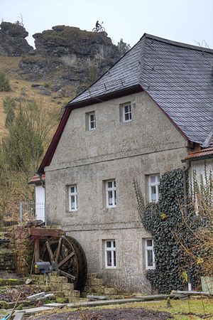
View of the north gable of the Stoffelsmühle. Before that, the water wheel installed in 2011; Above the mill is the statue of Kleinziegenfeld, a cyclist |
||
| Location and history | ||
|
|
||
| Coordinates | 50 ° 1 '20 " N , 11 ° 11' 57" E | |
| Location |
|
|
| Waters | Weismain | |
| Built | Possibly. 16th Century | |
| Shut down | 1887 | |
| Status | Mill technology removed and building converted into a private residence with holiday apartments | |
| technology | ||
| use | formerly as a flour mill , today as a small hydropower plant |
|
| Grinder | Formerly two grinders with two millstones | |
| drive | Watermill | |
| water wheel | Formerly: unknown Today: overshot water wheel to generate electricity |
|
| Website | stoffelsmuehle.de | |
The Stoffelsmühle (formerly also Obere Mühle) is a former grain mill in the Kleinziegenfelder Valley and an officially named part of the municipality of Weismain . It formerly belonged to the community of Kleinziegenfeld as a separate district and was owned by the local miller family Deinhardt for centuries.
The mill is located immediately north of the Kleinziegenfeld district of Grund an der Weismain , only 400 meters from its source. As a monument it is protected by the Bavarian State Office for the Preservation of Monuments under the monument number D-4-78-176-167 .
history
It is unclear exactly when the Stoffelsmühle was founded. Local researchers consider the year “1793” above the door to be the year of a renovation or partial new construction, but not as the date the mill was founded. The mill almost certainly dates from the 16th century, probably from around 1525. The Stoffelsmühle was first documented in 1617 as the "Obern Mühl" with its owner Lorenz Deinhardt. For 1657 the "Obere Mühl" was owned by Christoph Deinhardt, probably a son of Lorenz. Before 1770 an Adam Deinhardt was the master miller, from this year at the latest the mill was run by his descendants. At that time it belonged as a margravial-Brandenburg-Bayreuth fiefdom to the manor of Karl Franz von Schaumberg .
In 1809 the mill was first referred to as "Stophels Mühle" and bore the wheelhouse number 4 within the community of Kleinziegenfeld, which it still bears today. At that time, the master miller was Johann Deinhardt, who with his property was tenable and tenable for the von Schaumberg family. In 1826 the mill was equipped with "real mill justice on two grinding courses". So it had two water wheels for grinding grain, both of which ran well despite the proximity to the stream source, which is due to the particularly strong output of the source of 20 liters per second. Master millers were Johann Deinhardt's sons, Johann and Georg Deinhardt. In the middle of the 19th century, the miller Johann Georg Deinhardt (* 1805) was the largest bourgeois landowner in the village with over 82 days of work (28 hectares ), which testifies to its prosperity. A downpour in 1887 destroyed the mill with enormous amounts of water, so that operations had to be stopped.
The Deinhardt miller family sold the mill, and only a few years later it was sold on. In 1900 it was bought by the master magician Andreas Preißinger (1848–1929) from Kleinziegenfeld for 4,000 marks from the municipality of Stadelhofen. He built a wagon and carpentry shop in the mill building , which his son and his son-in-law ran until 1975. The couple Gisela Reiss and Werner Nowak acquired the mill in 1988 and began to renovate it themselves. Vacation apartments were also set up there.
On August 10, 2011, the Stoffelsmühle received a mill wheel again. The approximately 900 kilogram overshot paddle waterwheel was built and installed by the carpenter's workshop Martin Impler from Bad Feilnbach . With an output of 500 watts, it is used to generate electricity for private use in the mill. The installation of the wheel marked the end of the privately financed and executed mill renovation that was carried out by the mill's owners, which took a good two decades. During the renovation, the remains of an early medieval building of unknown function were discovered under the ground floor.
etymology
In the mentions of the mill from 1617, 1657 and 1770, the adjective "upper (right)" serves to distinguish it from the Schwarzmühle , which is located further downstream on the Weismain and is also a Schaumberg fief . The original form of today's name was first recorded in writing in 1809 with "Stophels Mühle". This includes the corruption "Stophel" or "Stoffel" for the first name Christopher (us), which is common in the East Franconian dialect and goes back to the master miller Christoph Deinhardt mentioned in 1657. The name of the mill was therefore already established over 200 years ago, which is also evidenced by the mentions as "Stoffelsmühl" (1838) and "Stoffelsmühle" (1853). The only surviving deviation of the name from this period is "Schlossmühle" from 1826, which underlines the ownership structure of the von Schaumberg family of Kleinziegenfeld Castle . In the local variety of the Upper Franconian dialect , the name is pronounced as [ šdo̧flsmül ] (pronounced: schdofflsmül ).
Population development
The table shows the population development of the Stoffelsmühle using individual data.
| year | Residents | Source: |
|---|---|---|
| 1871 | 9 | |
| 1875 | 9 | |
| 1885 | 6th | |
| 1900 | 7th | |
| 1925 | 7th | |
| 1950 | 7th | |
| 1958 | 7th | |
| 1959 | 7th | |
| 1960 | 6th | |
| 1961 | 5 | |
| 1962 | 5 | |
| 1963 | 4th | |
| 1970 | 4th | |
| 1987 | 1 |
architecture
The Stoffelsmühle is two-story with a massive stone basement and a plastered half-timbered structure on the first floor and in the gable. It is a so-called smoke house , since in the 17th and 18th centuries the smoke from the kitchen stove was led into the attic through a smoke vent that was still visible until a few years ago. In the 18th century, the blackening of the bars was increased by malting for beer production. The hipped roof is covered with slate .
Others
In 1915 the municipality of Stadelhofen had a pump house built on the property behind the mill, which, operated by water power, supplied Stadelhofen and the surrounding towns with drinking water until around 1970.
literature
- Jutta Böhm: Mill bike tour. Routes: Kleinziegenfelder Tal and Bärental , Weismain environmental station in the Lichtenfels district, Weismain / Lichtenfels (Lichtenfels district), 2000, 52 pages (numerous illustrations, canton)
- Dieter George: Lichtenfels; The old circle . Historical book of place names of Bavaria. Upper Franconia. Volume 6: Lichtenfels. Commission for Bavarian State History, Munich 2008, ISBN 978-3-7696-6862-9 . P. 150 f.
- Josef Urban: Small goat field . In: Heimatgeschichtliche Zeitschrift für der Landkreis Lichtenfels , Volume 10, Verlag Vom Main zum Jura, Eggolsheim 2001, pp. 24–51
- Josef Urban: New mill wheel at the Stoffelsmühle in Kleinziegenfeld . in: Fränkische Schweiz , Fränk.-Schweiz-Verein, Ebermannstadt 2011, pp. 36–37
Web links
- Official website of the Stoffelsmühle
- Stoffelsmühle in the local database of the Bayerische Landesbibliothek Online . Bavarian State Library
See also
List of mills on the Weismain and Krassach rivers
Individual evidence
- ↑ a b c d e f g h i j Böhm (2000), p. 34
- ↑ Stoffelsmühle in the local database of the Bavarian State Library Online . Bayerische Staatsbibliothek, accessed on July 3, 2017.
- ^ Mühle, Kleinziegenfeld 4 , geodaten.bayern.de, accessed on December 29, 2012
- ↑ a b c Mühlen 2012 , Tourist Information Oberes Maintal-Coburger Land, Lichtenfels 2012, PDF (131 KB), p. 2 ( Memento of the original from August 21, 2017 in the Internet Archive ) Info: The archive link was inserted automatically and not yet checked. Please check the original and archive link according to the instructions and then remove this notice.
- ↑ a b c d e f g h Gerhard Herrmann: A mill wheel floats over Kleinziegenfeld , In: Obermain-Tagblatt (Online: obermain.tmt-cms.de), August 11, 2011, accessed on December 29, 2012
- ↑ a b c d e f g h George (2008), p. 150 f.
- ↑ a b c d e f Urban (2001), p. 31
- ↑ Kgl. Statistical Bureau (ed.): Complete list of localities of the Kingdom of Bavaria. According to districts, administrative districts, court districts and municipalities, including parish, school and post office affiliation ... with an alphabetical general register containing the population according to the results of the census of December 1, 1875 . Adolf Ackermann, Munich 1877, 2nd section (population figures from 1871, cattle figures from 1873), Sp. 1081 , urn : nbn: de: bvb: 12-bsb00052489-4 ( digitized version ).
- ↑ Kgl. Statistical Bureau (ed.): Complete list of localities of the Kingdom of Bavaria. According to districts, administrative districts, court districts and municipalities, including parish, school and post office affiliation ... with an alphabetical general register containing the population according to the results of the census of December 1, 1875 . Adolf Ackermann, Munich 1877, section 3, p. 152 , urn : nbn: de: bvb: 12-bsb00052489-4 ( digitized version ).
- ↑ K. Bayer. Statistical Bureau (Ed.): Localities directory of the Kingdom of Bavaria. According to government districts, administrative districts, ... then with an alphabetical register of locations, including the property and the responsible administrative district for each location. LIV. Issue of the contributions to the statistics of the Kingdom of Bavaria. Munich 1888, Section III, Sp. 1029 ( digitized version ).
- ↑ K. Bayer. Statistical Bureau (Ed.): Directory of localities of the Kingdom of Bavaria, with alphabetical register of places . LXV. Issue of the contributions to the statistics of the Kingdom of Bavaria. Munich 1904, Section II, Sp. 1077 ( digitized version ).
- ↑ Bavarian State Statistical Office (ed.): Localities directory for the Free State of Bavaria according to the census of June 16, 1925 and the territorial status of January 1, 1928 . Issue 109 of the articles on Bavaria's statistics. Munich 1928, Section II, Sp. 1113 ( digitized version ).
- ↑ Bavarian State Statistical Office (ed.): Official place directory for Bavaria - edited on the basis of the census of September 13, 1950 . Issue 169 of the articles on Bavaria's statistics. Munich 1952, DNB 453660975 , Section II, Sp. 958 ( digitized version ).
- ↑ a b c d e population register Kleinziegenfeld 1958 (Stadtarchiv Weismain, A 022)
- ↑ Bavarian State Statistical Office (ed.): Official city directory for Bavaria, territorial status on October 1, 1964 with statistical information from the 1961 census . Issue 260 of the articles on Bavaria's statistics. Munich 1964, DNB 453660959 , Section II, Sp. 705 ( digitized version ).
- ^ Bavarian State Statistical Office (ed.): Official place directory for Bavaria . Issue 335 of the articles on Bavaria's statistics. Munich 1973, DNB 740801384 , p. 163 ( digitized version ).
- ↑ Bavarian State Office for Statistics and Data Processing (Ed.): Official local directory for Bavaria, territorial status: May 25, 1987 . Issue 450 of the articles on Bavaria's statistics. Munich November 1991, DNB 94240937X , p. 319 ( digitized version ).


